

NOAA expects El Niño to strengthen into winter 2026–27. Here’s the early region-by-region snow outlook for skiers across North America. This article discusses the Winter Weather Forecast 2027 to help you plan ahead.
Updated July 15, 2026
The Winter Weather Forecast 2027 is beginning to take shape, and one climate signal already stands above the rest: a potentially very strong El Niño.
In its July 9 update, NOAA’s Climate Prediction Center said El Niño is expected to strengthen through the end of 2026. Forecasters now give El Niño a 97% chance of continuing through early spring 2027 and an 81% chance of reaching “very strong” intensity between October and December 2026. If that forecast verifies, the event could rank among the largest El Niños observed since modern records began in 1950.
Unofficial Networks has been tracking the developing El Niño as the forecast has strengthened. But before skiers start booking nonrefundable powder trips, there is one important warning: El Niño does not mean more snow everywhere.
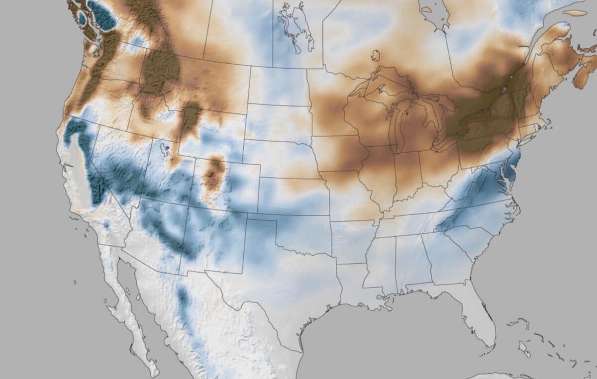
A strong El Niño typically pushes the Pacific storm track farther south. That can favor California, the Southwest and portions of the southern Rockies while bringing warmer or drier conditions to the Pacific Northwest, northern Rockies and western Canada. Even then, precipitation forecasts are not snowfall forecasts. Snow levels, elevation, storm temperature and the precise path of individual systems will determine whether a resort gets blower powder, heavy Sierra cement or rain at the base.
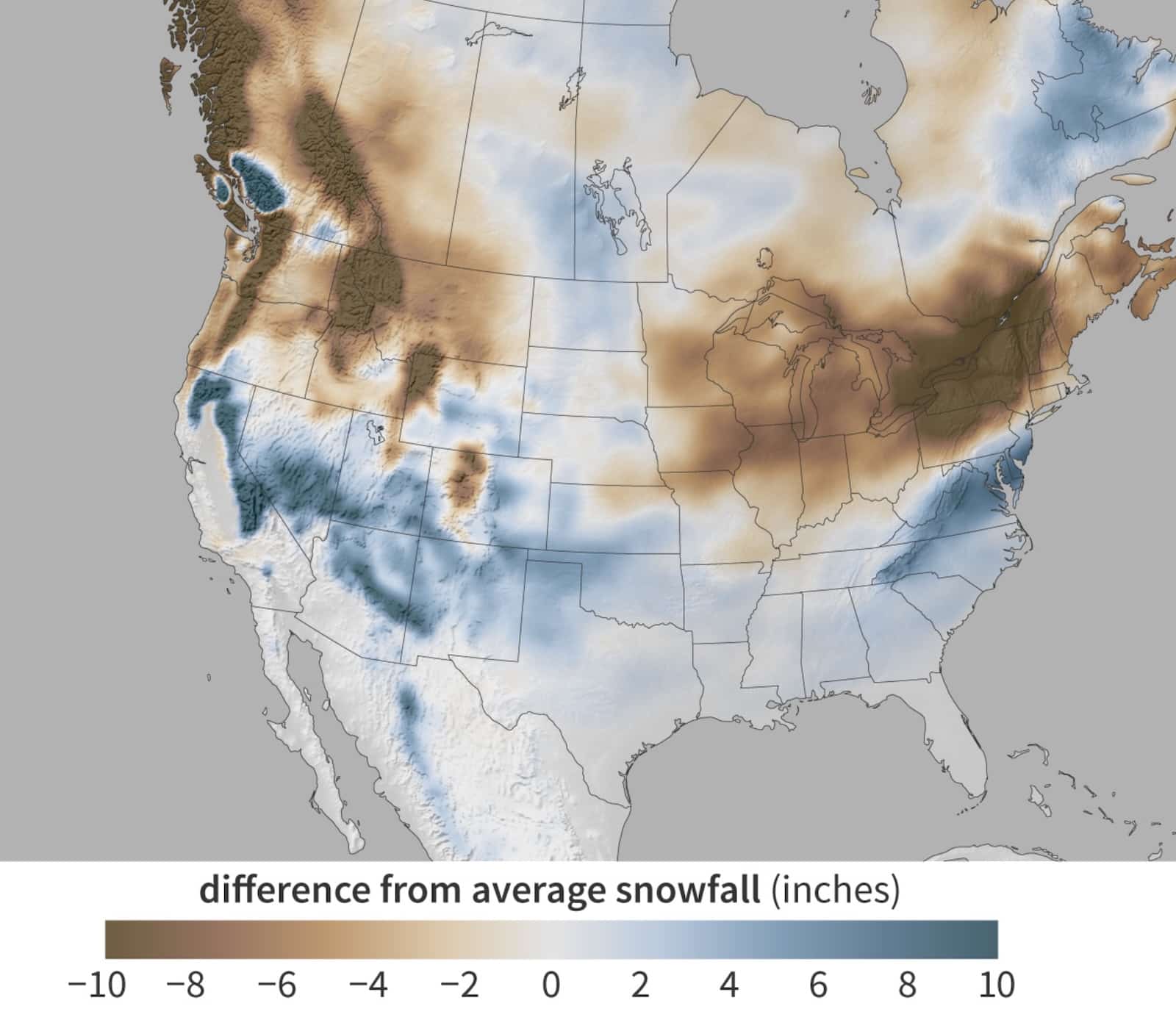
Snowfall during moderate-to-strong El Niño winters
Winter Weather Forecast 2027 at a glance
| Ski region | Early 2026–27 lean | Primary concern |
|---|---|---|
| California and the Sierra Nevada | Above-average snow potential at elevation | Warm atmospheric rivers and high snow levels |
| Arizona and New Mexico | Above-average potential | Long dry gaps between storm cycles |
| Southern Colorado and the San Juans | Above-average potential | Small shifts in the storm track |
| Utah | Near to above average | Warm storms and variable storm placement |
| Pacific Northwest | Mixed, with greater downside at lower elevations | Warmth, rain and elevated snow levels |
| Northern Rockies | Near to below average | Drier northern storm track |
| British Columbia and Alberta | Near to below average overall | Milder temperatures, particularly in western Canada |
| Great Lakes and interior Northeast | Highly variable, with below-average seasonal risk | Thaws, mixed precipitation and fewer sustained cold periods |
These are broad seasonal tendencies—not resort-level snowfall predictions. NOAA’s historical composites show that strong El Niño winters tend to favor snowfall across parts of California, Nevada, Utah, Colorado, Arizona and New Mexico, while reducing snowfall in the Pacific Northwest, northern Rockies, Great Lakes and parts of interior New England.
What NOAA is forecasting for winter 2026–27
NOAA’s current outlook contains two important pieces of information for skiers.
First, the ocean-atmosphere pattern is already firmly in El Niño territory. NOAA reported a weekly Niño-3.4 sea-surface temperature anomaly of approximately +1.2°C in early July, with unusually warm water also present closer to the South American coast. Forecast models generally expect further strengthening during the fall.
Second, NOAA’s June seasonal outlook favors above-normal precipitation extending from Southern California and the Desert Southwest toward the Great Basin and central Rockies during portions of the cold season. At the same time, below-normal precipitation becomes more likely across the Northwest and northern Rockies, particularly during the core winter months. Temperatures are also favored to run above normal across much of the West and northern United States.
That combination creates a recognizable El Niño ski forecast: more moisture across parts of the southern West, but potentially warmer storms and a less favorable pattern farther north.
California and the Sierra Nevada: The greatest upside
California may have the most dramatic upside in the Winter Weather Forecast 2027.
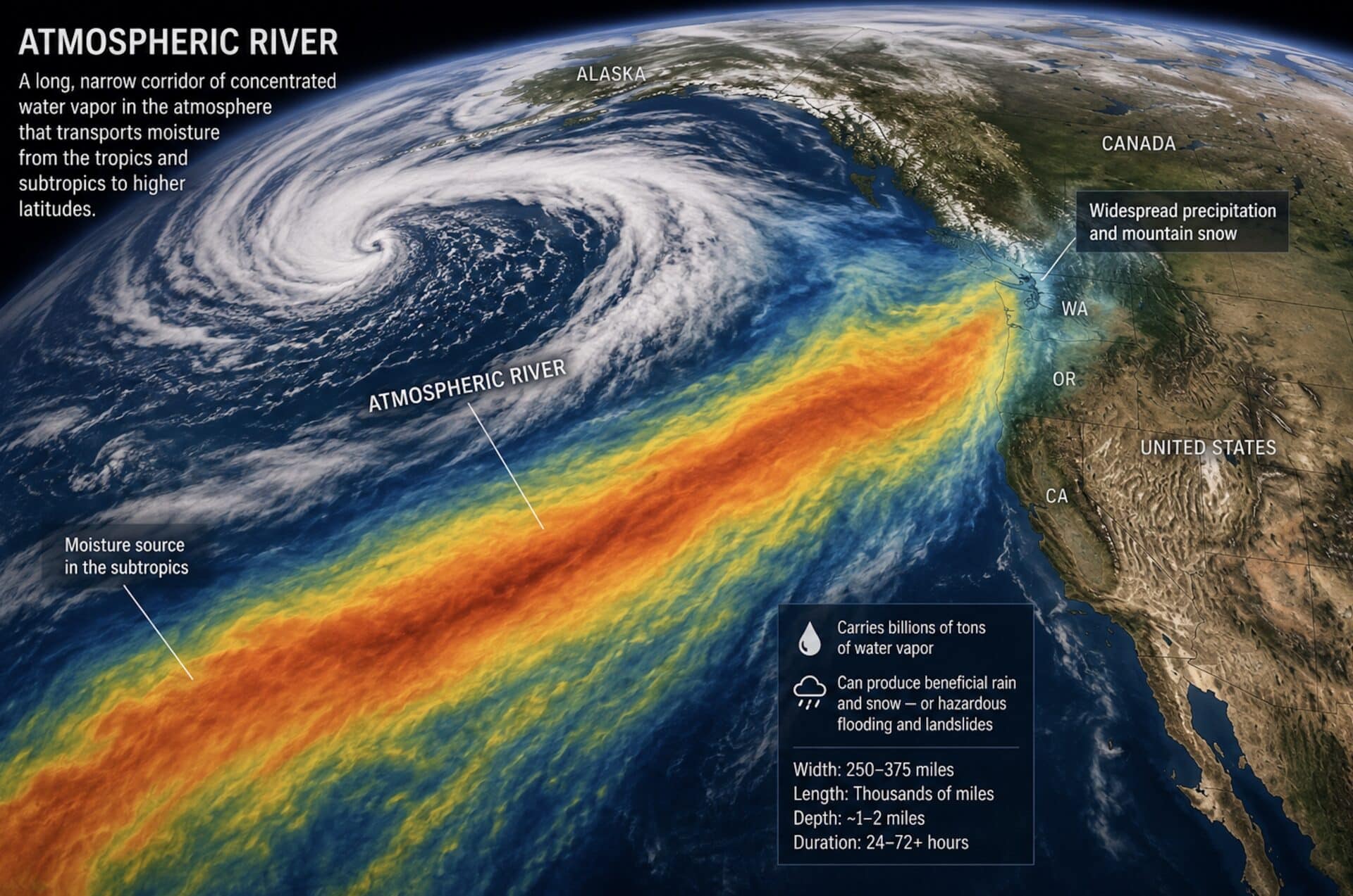
Historical strong El Niño winters have frequently produced above-average high-elevation snowfall in California. A southerly Pacific storm track can send repeated systems toward the Sierra Nevada, occasionally accompanied by powerful atmospheric rivers.
That puts high-elevation terrain at Mammoth Mountain, Palisades Tahoe, Kirkwood, Sugar Bowl and other Sierra resorts firmly on the watch list.
The critical phrase is high elevation.
El Niño winters are often warm, and atmospheric rivers can carry subtropical air along with enormous amounts of moisture. A storm could deliver several feet of snow near a summit while producing rain or extremely dense snow near lower base areas. The Sierra could finish with huge water content without every storm delivering ideal powder conditions.
California outlook
Seasonal lean: Above-average snowfall potential at higher elevations
Confidence: Moderate
Biggest risk: Warm storms and fluctuating snow levels
For continuing regional coverage, follow the Unofficial Networks California page.
Arizona and New Mexico: Strong contenders for an excellent season
Arizona and New Mexico are among the most consistently favored areas during stronger El Niño winters.
A southern storm track can carry Pacific moisture into the Southwest, increasing the chances of meaningful storm cycles at Arizona Snowbowl, Taos Ski Valley, Ski Santa Fe, Angel Fire and other high-elevation ski areas.
These resorts do not need nonstop snowfall to produce a memorable winter. Several well-placed, moisture-rich systems can transform the season—especially when temperatures are cold enough to keep snow levels below the base.
The downside is volatility. The Southwest can alternate between major snow cycles and extended sunny periods, even during a favorable El Niño.
Arizona and New Mexico outlook
Seasonal lean: Above-average snowfall potential
Confidence: Moderate
Biggest risk: Long dry periods between storms
More regional reporting is available on the Unofficial Networks New Mexico page.
Colorado: Watch the San Juans
Colorado’s outcome will depend heavily on how far north and east the Pacific storm track travels.
The early pattern most strongly favors the southern and central Rockies. That makes Wolf Creek, Telluride, Silverton, Purgatory and other San Juan Mountains ski areas particularly interesting heading into winter.
Monarch, Crested Butte, Aspen Snowmass and other central Colorado mountains could also benefit when storms track across the Four Corners region. Farther north, the forecast becomes less certain. Resorts such as Steamboat could still experience excellent storm cycles, but the broad El Niño signal is not as favorable there as it is in southern Colorado.
Colorado outlook
Southern Colorado: Above-average potential
Central Colorado: Near to above-average potential
Northern Colorado: Near average, with higher uncertainty
Biggest risk: The storm track remaining too far south
See the Unofficial Networks Colorado page for resort and storm updates throughout the season.
Utah: Promising, but not a lock
Utah occupies a transition zone in this forecast.
Historical strong El Niño snowfall patterns can favor the state, and NOAA’s precipitation outlook extends wetter probabilities into the Great Basin. That gives southern Utah and the central and southern Wasatch a plausible path to an above-average winter.
Alta, Snowbird, Brighton and Solitude also have elevation and favorable terrain working in their favor. Even when regional temperatures run warm, the upper Wasatch can convert moisture into snow more effectively than lower-elevation areas.
However, El Niño does not favor northern Utah as consistently as it favors the Southwest or parts of California. A small change in storm trajectory could leave Utah in the middle—close to the action, but not always directly under it.
Utah outlook
Seasonal lean: Near to above average
Confidence: Low to moderate
Biggest risk: Storms splitting around or tracking south of the Wasatch
Follow the Unofficial Networks Utah page and Snowbird resort page for updates.
Pacific Northwest: Warmth is the biggest concern
Washington and Oregon face a more challenging setup.
El Niño often shifts the strongest Pacific jet-stream energy south of the region. NOAA’s current winter guidance also favors warmer-than-normal conditions across the Northwest, increasing the risk of elevated snow levels.
The Cascades will still receive storms. This is not a forecast for a snowless winter. High-elevation terrain at Mount Baker, Crystal Mountain, Mount Hood and Mount Bachelor could still experience major powder cycles.
The concern is that lower and middle elevations may see more rain, mixed precipitation or heavy wet snow than skiers would prefer. A few warm storms can have an outsized effect on base depth and surface quality.
Pacific Northwest outlook
Seasonal lean: Near to below average, especially at lower elevations
Confidence: Moderate
Biggest risk: High snow levels and rain during Pacific storms
Montana, Idaho and Wyoming: A tougher northern signal
The northern Rockies currently sit on the less favorable side of the large-scale pattern.
NOAA’s winter outlook increases the probability of below-normal precipitation across parts of the northern Rockies while favoring above-normal temperatures across much of the northern tier. Historical El Niño snowfall composites also show a tendency toward reduced snowfall in this region.
That does not eliminate powder days at Jackson Hole, Grand Targhee, Big Sky, Whitefish, Sun Valley or Brundage. Orographic lift, local terrain and short-term atmospheric patterns can still generate excellent storm cycles.
The seasonal concern is consistency. These mountains may be more vulnerable to extended dry stretches than resorts farther south.
Northern Rockies outlook
Seasonal lean: Near to below average
Confidence: Moderate
Biggest risk: Fewer sustained storm cycles
Regional Wyoming coverage is available on the Unofficial Networks Wyoming page.
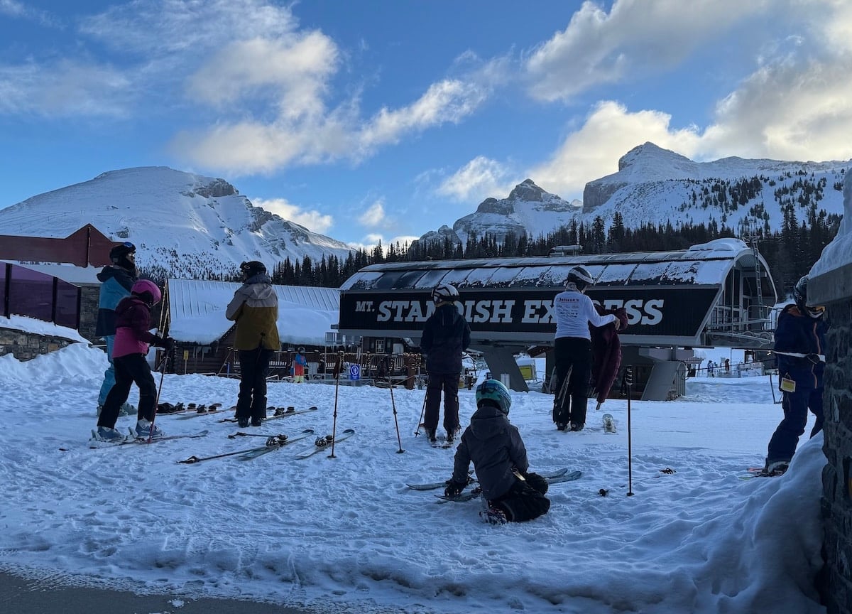
British Columbia and Alberta: Milder conditions may dominate
Western Canada historically tends to run milder during El Niño winters.
Environment and Climate Change Canada notes that El Niño is commonly associated with warmer-than-normal winters across western, northwestern and central Canada. Research examining Canadian snowfall has also found reduced snowfall across portions of southern British Columbia during El Niño winters.
That creates snow-level concerns for lower-elevation and coastal areas. Higher mountains—including terrain at Whistler Blackcomb, Revelstoke and other interior resorts—can still receive major snowfalls when Pacific moisture reaches the region.
The overall signal, however, is less favorable than it is for the southern United States.
Western Canada outlook
Seasonal lean: Near to below average
Confidence: Moderate
Biggest risk: Mild temperatures and elevated freezing levels
Follow the Unofficial Networks Whistler Blackcomb page for regional coverage.
Great Lakes and Northeast: Expect volatility
El Niño winters can be complicated in the eastern United States.
Historical NOAA analysis shows reduced seasonal snowfall across much of the Great Lakes and interior New England during moderate-to-strong El Niño events. Warmer stretches can interrupt otherwise productive storm patterns, while mixed precipitation and rain become greater concerns.
That does not rule out major East Coast storms. El Niño can help energize the southern branch of the jet stream, and a properly positioned coastal system can still produce a significant nor’easter.
The challenge is sustaining cold air. The Northeast could experience a handful of memorable storms without finishing the season above average overall.
Northeast outlook
Seasonal lean: Variable, with below-average risk inland and around the Great Lakes
Confidence: Low
Biggest risk: Thaws and mixed precipitation between major storms
The ski regions to watch most closely
Based on the information available in July 2026, four areas stand out:
- The high Sierra Nevada, especially Mammoth and higher-elevation Tahoe terrain.
- Arizona and New Mexico, including Arizona Snowbowl and Taos Ski Valley.
- Colorado’s San Juan Mountains, including Wolf Creek, Telluride and Silverton.
- High-elevation Utah, particularly when storms track through the Great Basin.
Unofficial Networks previously identified seven ski resorts that could benefit from a strong El Niño. Those resorts should be treated as a watch list, not a guaranteed ranking.
What could change the Winter Weather Forecast 2027?
El Niño establishes the background pattern, but it does not control every storm.
Several shorter-term atmospheric factors could override the seasonal signal for days or weeks:
- The exact position of the Pacific jet stream
- Atmospheric-river strength and temperature
- Snow levels during individual storms
- Arctic and North Atlantic blocking patterns
- Polar-vortex disruptions
- Madden–Julian Oscillation activity
- Persistent ridges or troughs over western North America
A favorable seasonal precipitation outlook can also produce disappointing skiing when the moisture arrives as rain. Conversely, a below-average season can still contain several unforgettable powder cycles.
That is why seasonal outlooks are best used to identify broad probabilities—not to book a specific powder day six months in advance.
Winter Weather Forecast 2027 FAQ
Will the winter of 2026–27 be snowy?
Some regions currently have a stronger chance of above-average snowfall than others. California’s higher elevations, Arizona, New Mexico, southern Colorado and parts of Utah appear to have the most favorable early signal. The Pacific Northwest, northern Rockies and western Canada face greater warmth and below-average snowfall risk.
Is El Niño good for skiing?
It depends on the location. Strong El Niño winters can be excellent for the Southwest, California and portions of the southern Rockies. They are often less favorable for the Pacific Northwest, northern Rockies and western Canada.
Which ski resorts could receive the most snow?
It is too early to predict resort snowfall totals. Based on the broad climate pattern, high-elevation resorts in the Sierra Nevada, Arizona, New Mexico, southern Colorado and Utah deserve the most attention.
Can a long-range forecast predict individual powder days?
No. Seasonal forecasts estimate whether temperature and precipitation are more likely to finish above, near or below normal over a period of months. They cannot determine the timing, temperature or exact path of individual storms.
When will this forecast be updated?
NOAA updates its seasonal outlooks monthly. Its next ENSO Diagnostic Discussion is scheduled for August 13, 2026. This article should be updated after each major NOAA forecast through November and whenever the expected strength or duration of El Niño changes.
Bottom line
The early Winter Weather Forecast 2027 favors a potentially active ski season across the southern half of the western United States.
A strengthening El Niño increases the odds of productive storm cycles in California, Arizona, New Mexico, southern Colorado and possibly Utah. Meanwhile, warmer and potentially drier conditions create more risk for the Pacific Northwest, northern Rockies and western Canada.
This is not a blanket forecast for record snowfall, and it is far too early to predict exact resort totals. But for skiers deciding which regions to watch, the high Sierra, Southwest and San Juan Mountains currently offer the most compelling upside.
How this forecast was produced: This outlook combines NOAA Climate Prediction Center seasonal forecasts, current ENSO guidance, historical El Niño snowfall composites and Environment and Climate Change Canada research. Seasonal forecasts describe probabilities across large regions and cannot predict individual resort snowfall totals.