
Climatologists with NOAA are still waiting for the atmosphere to respond to rising temps in the Pacific Ocean but the water is plenty warm.
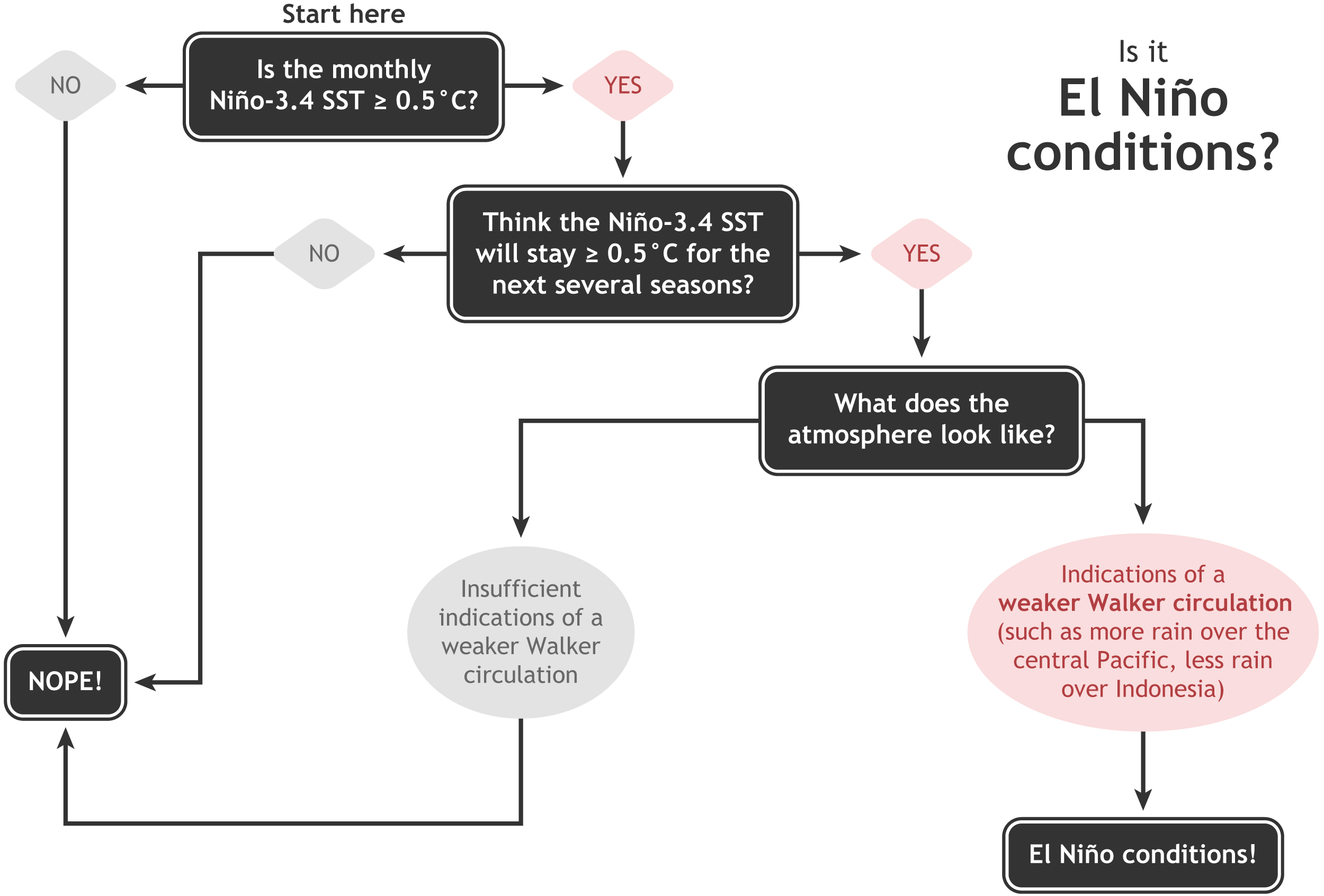
So warm in fact that scientists are currently projecting an 80% chance of El Niño going into effect sometime between now and the official start of winter (Dec. 21).
Check out the whole post below for a in-depth explanation….
What's going on with #ElNino? You can always get the latest #enso updates and announcements by visiting: https://t.co/x8cb8D013w pic.twitter.com/CfUjExzplH
— NOAA Climate.gov (@NOAAClimate) November 18, 2018
Full NOAA Post:
The surface of the east-central tropical Pacific is nearly 1°C warmer than the long-term average! We haven’t seen the atmospheric response that characterizes El Niño conditions quite yet, though. Forecasters estimate about an 80% chance that El Niño will form soon, and continue into the spring.
Where do I begin:
Let’s run the numbers! All four of the ENSO monitoring regions in the tropical Pacific were warmer than average in October. The Niño3.4 region was 0.8°C warmer than average using the ERSSTv5 dataset with the long-term trend removed, comfortably above the El Niño threshold of 0.5°C above average.

To qualify as El Niño conditions, though, we have to see evidence that the atmosphere is responding to the warm sea surface temperatures. In brief, the average atmospheric pattern over the tropical Pacific, the Walker circulation, is powered by warm air rising over the very warm waters of the far western Pacific and Indonesia. This air travels eastward at high levels in the atmosphere, descends in the eastern Pacific, and completes the circulation by traveling westward near the surface, forming the trade winds.
During El Niño, warmer-than-average water in the east/central Pacific results in more rising air, clouds, and rain than normal in that region. This weakens the whole Walker circulation, meaning both the upper-level and lower-level winds are slower than normal. For a more thorough treatment of the Walker circulation and its role in ENSO, check out Tom’s post on the subject.
We monitor the tropical Pacific atmosphere a few different ways. The Southern Oscillation Index measures the difference in sea level pressure between Darwin, Australia and Tahiti. When it’s negative, it’s telling us that pressure is higher than average in Darwin and lower than average in Tahiti. (Lower pressure accompanies more rising air than average.) A negative Southern Oscillation Index indicates that El Niño-y atmosphere… right now it’s positive, 0.4.

In a similar vein, the Equatorial Southern Oscillation Index measures the pressure differences between the western and eastern equatorial Pacific. The EQSOI was slightly negative in October, -0.3, not convincing evidence of an atmospheric response.
Another way to monitor the atmospheric circulation in the Pacific is to look at the amount of clouds or rainfall in the equatorial region. If the Walker circulation had weakened, we’d expect more clouds than average in the central Pacific, and less cloudiness over Indonesia. However, the cloud cover in the central Pacific was a little less than average last month. The amount of clouds/rainfall is also important because this drives the teleconnections that impact the Pacific-North America region. Right now there’s no evidence we’re seeing those teleconnections despite the ocean conditions being favorable.

Light my fire
All of the above is to say… El Niño conditions haven’t kicked in just yet. Most of the computer models are predicting that sea surface temperatures will remain above average, with the anomaly (departure from the long-term average) remaining above the El Niño threshold of +0.5°C through the spring.

Climate model forecasts for the Niño3.4 Index. Dynamical model data (purple line) from the North American Multi-Model Ensemble (NMME): darker purple envelope shows the range of 68% of all model forecasts; lighter purple shows the range of 95% of all model forecasts. Statistical model data (dashed line) from CPC’s Consolidated SST Forecasts. NOAA Climate.gov image from CPC data.
However, adding confidence to the model forecasts is the substantial amount of warmer-than-average water below the surface of the Pacific. The October average was the 5th-highest since 1979. These waters will provide a source of warmer water to the surface for the next few months.
So we have the first two requirements on our El Niño decision tree. It’s expected that the atmosphere will respond to the warmer surface temperatures… when it does, El Niño conditions will have arrived. In 2014, the ocean was above the El Niño threshold for several months, but the atmosphere was slow to respond. There are some key differences this time around (sea surface temperatures are a little warmer, and subsurface temperatures are much warmer), so we’re not predicting an identical outcome. Plus, one thing you can bet on is that nature will never behave exactly the same way twice.
For all your breaking ENSO News, watch this space!