

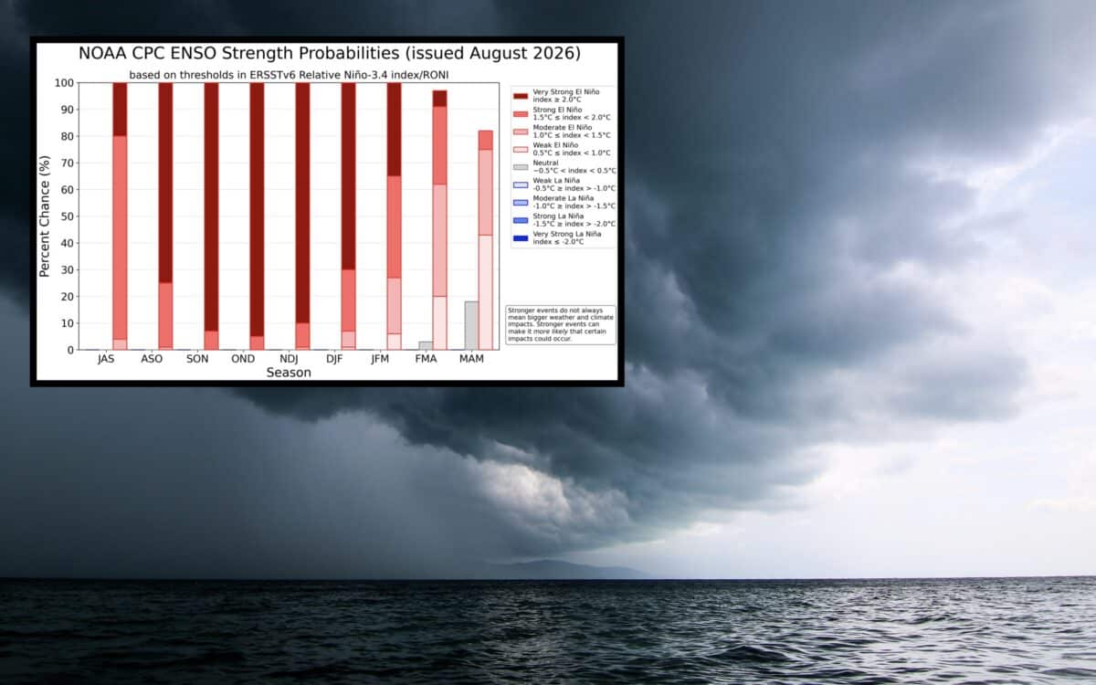
El Niño is quickly strengthening across the tropical Pacific, and now NOAA’s Climate Prediction Center is warning that the pattern has more than a 90% chance of becoming a very strong event during the Northern Hemisphere fall and winter of 2026-2027. The latest monthly El Niño Southern Oscillation diagnostic discussion from NOAA’s CPC, released on August 13th, 2026, places the ENSO Alert System at El Niño Advisory status.
El Niño Strengthens Across the Pacific
Based on the report, sea surface temperature anomalies in the eastern equatorial Pacific reached over 2.0 degrees Celsius during the past month. In July, Niño index values reached 1.4 degrees Celsius in the Niño 3.4 region, 1.7 degrees in Niño 3 and 2.9 degrees in Niño 1+2.
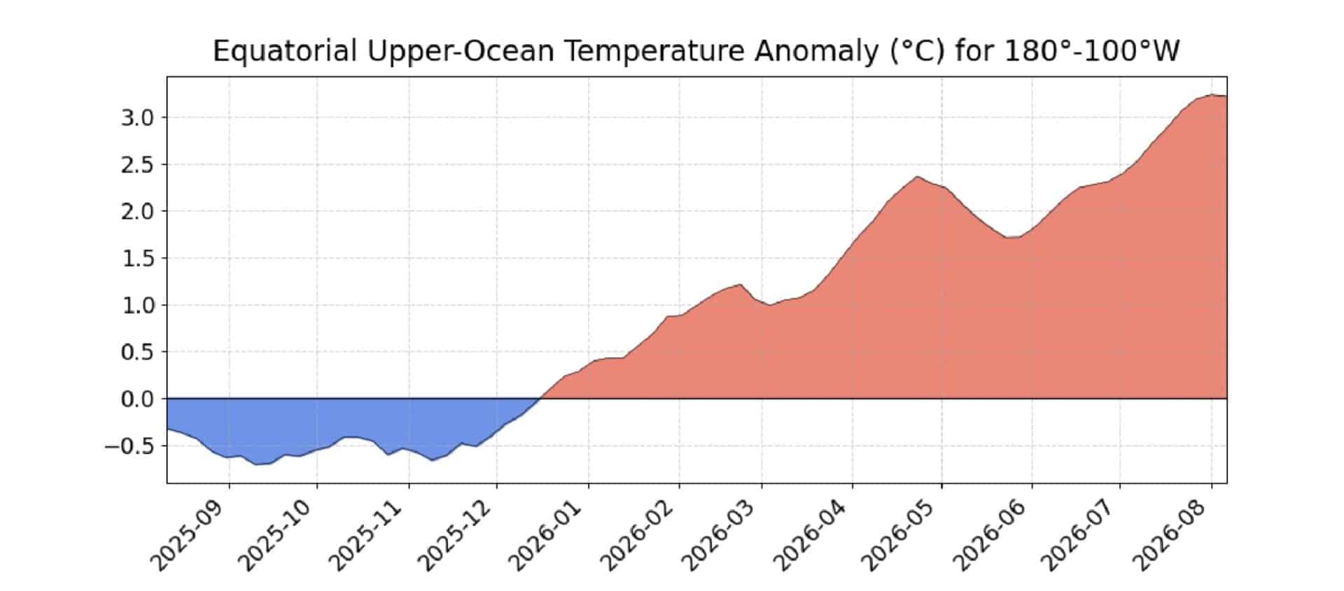
Conditions beneath the ocean surface also support the strengthening event, with the equatorial subsurface temperature index increasing during July and temperature anomalies reaching as high as 10 degrees Celsius at depth. In the atmosphere, low level westerly wind anomalies and upper level easterly wind anomalies stretched from the western to east central equatorial Pacific.
Rainfall patterns are also shifting, with convection and rainfall increasing across the central and eastern Pacific while conditions were drier than average over Indonesia.
NOAA Warns of Potentially Historic Strength
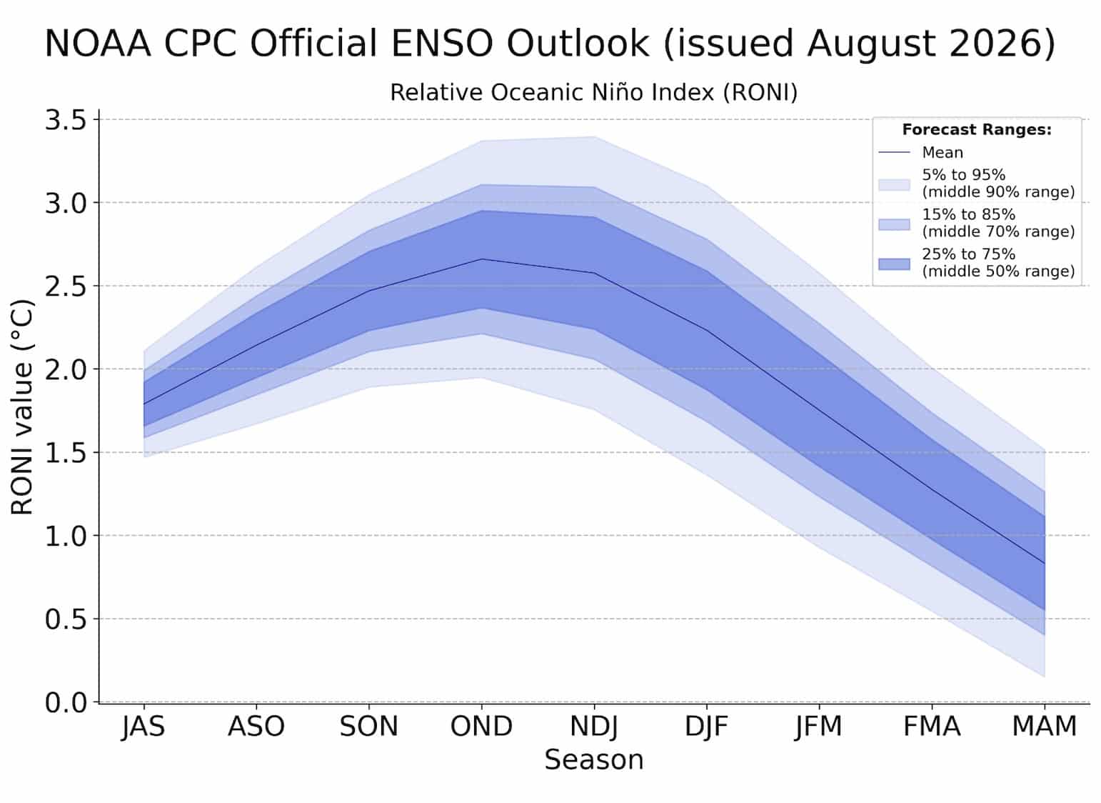
The ENSO Outlook, which combines numerous climate models from North American and around the world, shows that El Niño is expected to continue strengthening through the end of 2026. Currently the agency gives the October through December period a 69% chance of producing a historic El Niño event, defined as a three month RONI value of at least 2.5 degrees Celsius. If it reaches that, this would rank among the strongest El NIño events observed since 1950.
In the case that it does reach that level, the likelihood of weather and climate impacts associated with the patter would increase. Those impacts are not guaranteed though, and they can vary considerably by location and season.
What a Strong El Niño Could Mean for Winter
A very strong El Niño could have some major implications for weather patterns across the United States and other parts of the world through the 2026-2027 winter. El Niño influences the position and strength of the jet stream, storm tracks, precipitation patterns, and temperatures. Specifically in the western United States, seasonal snowfall patterns can shift considerably during a strong El Niño winter.
A strong pattern does not guarantee a specific snowfall outcome for any individual ski resort or region, but it is worth watching closely for skiers and snowboarders eagerly awaiting the winter ahead.
NOAA Will Continue Monitoring El Niño
NOAA and the National Weather Service update oceanic and atmospheric conditions associated with ENSO on a weekly basis. The next monthly ENSO Diagnostic Discussion is scheduled for release on September 10th, 2026. Until then, forecasters will continue to monitor the sea surface temperatures, subsurface ocean conditions, atmospheric circulation, and rainfall patterns across the Pacific, as the always do.