

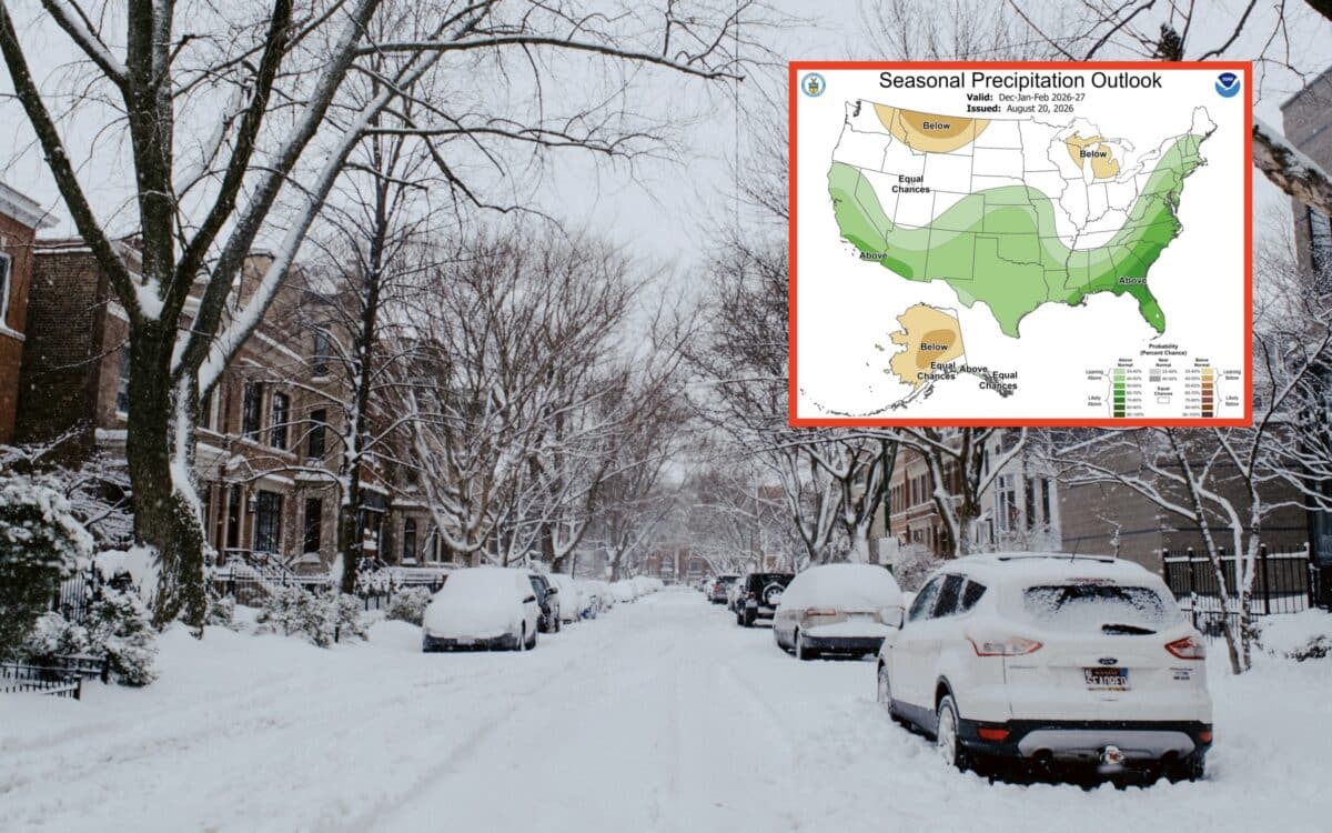
NOAA has released an updated winter weather outlook for the 2026-2027 season, giving skiers and snowboarders a fresh look at temperature and precipitation trends across the United States.
The National Oceanic and Atmospheric Administration’s Climate Prediction Center released the updated forecast on August 20th, 2026. The latest maps cover December 2026 through February 2027 and show a pronounced split between warmer conditions across much of the northern United States and wetter conditions across large portions of the South and West.
The forecast does not predict snowfall totals at individual ski resorts, but it provides an important early look at the broader weather patterns that could influence the heart of the 2026-27 ski season.
NOAA’s Winter Temperature Prediction For December 2026 – February 2027
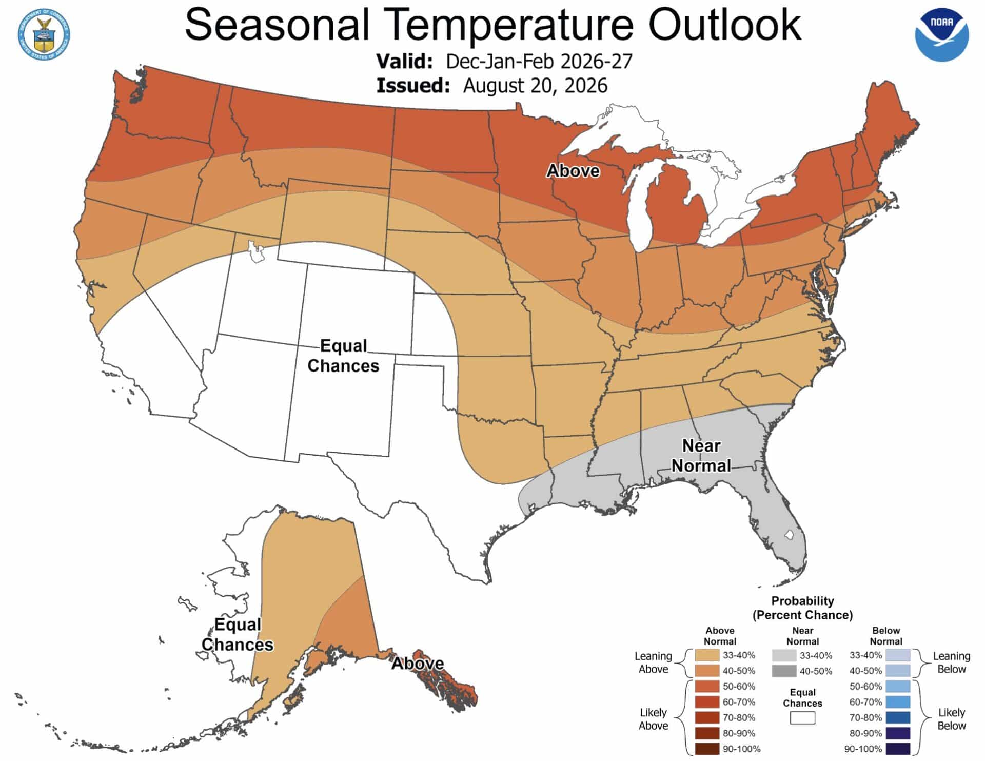
The updated temperature outlook favors above-normal temperatures across a large portion of the United States.
The strongest warm signal covers much of the northern tier, including the Pacific Northwest, northern Rockies, northern Plains, Great Lakes and Northeast. Alaska also has a strong signal for above-normal temperatures.
Meanwhile, much of the Southwest and portions of the central and southern United States are shown with equal chances of above-normal, near-normal or below-normal temperatures. The Gulf Coast and parts of the Southeast stand out as areas where near-normal temperatures are favored.
For skiers and snowboarders, the temperature outlook presents a fairly complicated picture. Warmer seasonal temperatures do not mean ski areas in those regions will not receive snow. Individual storms can still bring major cold outbreaks and heavy snowfall even when a three-month period averages warmer than normal.
NOAA’s Precipitation Forecast For December 2026 – February 2027
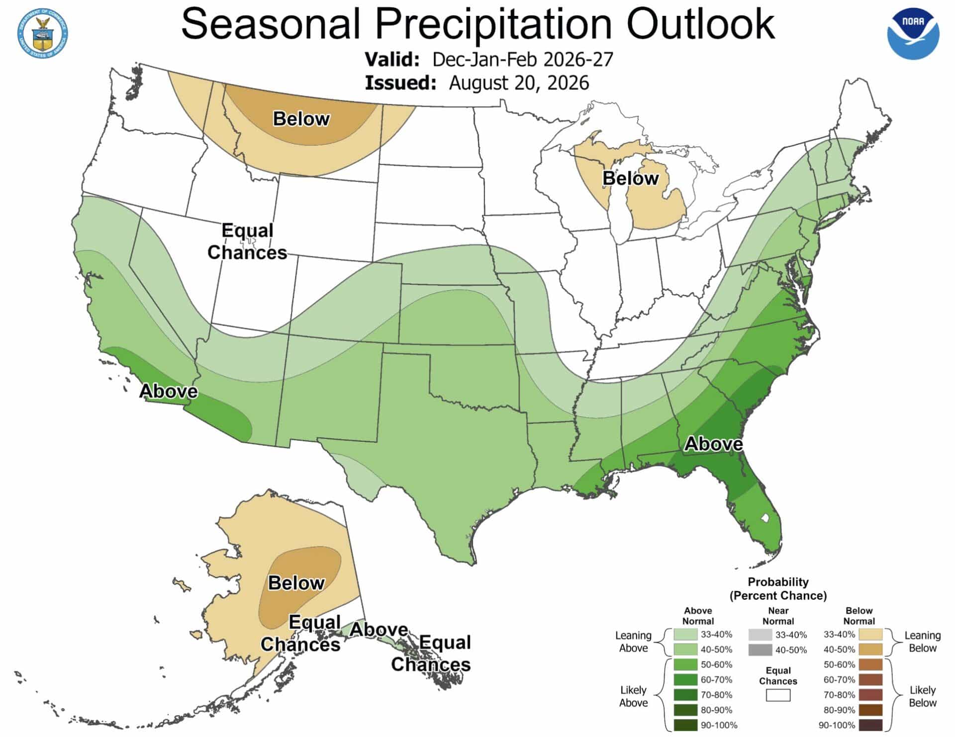
The precipitation outlook looks quite a bit different. NOAA favors above-normal precipitation across a broad portion of the southern United States and parts of the West. The strongest signals extend across Southern California, Arizona, New Mexico, Texas, the Gulf Coast and Southeast.
The map also shows above-normal precipitation extending up the East Coast.
At the same time, portions of the Pacific Northwest, northern Rockies, northern Plains and Great Lakes are leaning toward below-normal precipitation.
That creates a potentially important setup for southern ski regions. More precipitation does not automatically mean more snow, but higher-elevation mountains could benefit if enough of that moisture arrives with sufficiently cold temperatures.
A Strong El Niño Remains A Major Factor
The updated NOAA outlook arrives less than two weeks after NOAA warned that El Niño was rapidly strengthening across the tropical Pacific.
NOAA’s August 13th discussion placed the ENSO Alert System at El Niño Advisory status and gave the developing event more than a 90 percent chance of becoming a very strong El Niño during the Northern Hemisphere fall and winter of 2026-27.
The previous report also noted that sea surface temperature anomalies in the eastern equatorial Pacific had reached more than 2 degrees Celsius during the preceding month. NOAA’s outlook gave the October through December period a 69 percent chance of producing a historic El Niño, defined in that report as a three-month RONI value of at least 2.5 degrees Celsius.
A very strong El Niño can influence the position and strength of the jet stream, storm tracks, precipitation patterns and temperatures. The pattern can also produce significant changes in seasonal snowfall across the western United States.
However, the previous NOAA report emphasized that a strong El Niño does not guarantee a particular snowfall outcome for an individual ski resort or region.
What The New Forecast Could Mean For Ski Resorts
The combination of NOAA’s temperature and precipitation maps creates several areas worth watching as winter approaches.
Southern California, Arizona, New Mexico and portions of the southern Rockies have a favorable precipitation signal. If temperatures cooperate, high-elevation ski areas in those regions could benefit from an active winter storm pattern.
The northern Rockies and Pacific Northwest face a more challenging combination. Above-normal temperatures and below-normal precipitation are both favored across portions of the region, which could mean fewer favorable storm cycles or higher snow levels during some storms.
The Northeast presents a different situation. Above-normal temperatures are favored across much of the region, but the wetter precipitation signal could still produce significant snow events if individual storms encounter sufficiently cold air.
This Is Still An Early Winter Forecast
Skiers should not treat the August 20th outlook as a prediction of how much snow a particular resort will receive. NOAA’s seasonal forecasts describe probabilities for average temperature and precipitation over a three-month period. They cannot predict individual storms several months in advance.
The most important takeaway from the latest forecast is the broad regional pattern. Much of the northern United States is favored to be warmer than normal, while the southern United States has a stronger signal for above-normal precipitation.
That could make the 2026-27 ski season particularly interesting for the southern Rockies, Southwest and California, while creating more questions for portions of the Pacific Northwest and northern Rockies.
NOAA will continue updating its seasonal outlooks as winter approaches, giving skiers several more opportunities to see whether these early signals strengthen or shift.
