

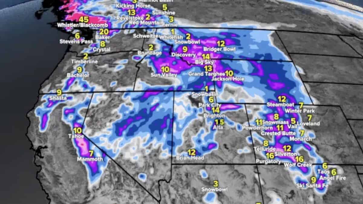
After a stretch of unfavorable weather patterns for much of the interior West, there is some encouraging news for skiers and snowboarders. A shift in the forecast could bring multiple rounds of snow to the Rocky Mountains, Sierra Nevada, and other western mountain ranges beginning later this week.
In his latest mountain weather forecast, meteorologist Chris Tomer outlined a developing pattern that could bring the first storm system around November 13th-14th, followed by potentially stronger systems between November 16th and 18th. If the forecast holds, several ski regions could see their first meaningful snowfall in some time.
A Pattern Change Could Open The Door For Snow
The Pacific Northwest and British Columbia have continued to receive the bulk of the active storm track, while high pressure has largely kept storms away from the interior West. That pattern could finally begin changing around November 13th.
Tomer is tracking a low-pressure system moving through California that could help break down the high pressure over the Four Corners region. That would allow subsequent storms to push farther inland, bringing precipitation to Utah, Colorado, Wyoming, Idaho, and the Southwest.
The Sierra Nevada could see the first snowfall around November 13th, with the Wasatch, Colorado Rockies, and other interior ranges getting involved around November 14th. Additional storms could follow through November 18th.
Several Feet Of Snow Possible In The Sierra And Rockies
The latest forecast shows a significant improvement in potential snowfall totals across several western mountain ranges.
Tomer’s projections through November 18 include:
- Sierra Nevada: 6–12 inches at many ski resorts, with 1–2 feet possible along the highest portions of the Sierra.
- Utah: 8–16 inches possible across Little and Big Cottonwood Canyons.
- Colorado: 6–12 inches across many central and northern mountain areas, with 1–2 feet possible in the San Juan Mountains.
- Tetons: Potentially a foot or more in some higher elevations.
- Pacific Northwest: Continued significant snowfall potential as the active storm track remains focused farther north.
Some of the individual mountain snow forecasts are even more encouraging. Tomer’s models show 15–20 inches possible at mid-mountain elevations at Alta by November 18th–19th. Jackson Hole could see around 20 inches at higher elevations, while Kirkwood could potentially receive 2–3 feet or more.
More Storms Could Follow
Perhaps the most encouraging part of the forecast is that November 18 might not mark the end of the activity. Tomer noted additional storm systems could follow, with the broader pattern potentially shifting more moisture toward California and eventually benefiting the interior Rockies heading into December.
For western ski resorts hoping to improve early-season conditions, this would be a welcome development. Several areas are already open for skiing, while others are working toward their planned opening dates.
There is still plenty of uncertainty surrounding the timing and eventual strength of these storms, but the latest forecast certainly offers some reasons to be optimistic.