
[protected-iframe id=”8eb6932b41fe77722eca0957199c2d87-65244901-84409940″ info=”https://www.facebook.com/plugins/video.php?href=https%3A%2F%2Fwww.facebook.com%2FChrisTomer%2Fvideos%2F1879726315373654%2F&show_text=0&width=560″ width=”560″ height=”315″ frameborder=”0″ style=”border:none;overflow:hidden” scrolling=”no”]
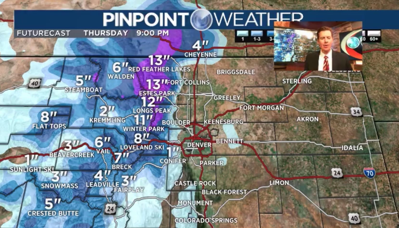
“By Thursday night we’re at the grand totals, about a foot up on Longs [Peak]” – Chris Tomer
Spring snow is coming to Colorado this week with upwards of 13″ for parts of the Front Range by Friday morning reports KDVR meteorologist, Chris Tomer. Expect plentiful snowfall along the Continental Divide, which should make for possible powder days at Loveland and A-Basin.
https://twitter.com/chris_tomer/status/991279380407123968
Forecast Totals:
- Loveland Ski Area — 8-10″
- Arapahoe Basin — 8-10″
NOAA Hazardous Weather Outlook
DAY ONE…Today and Tonight
Scattered showers and thunderstorms will develop this afternoon over the mountains and plains before diminishing later in the evening. The best chance for storms will be along and north of a line from Denver to Akron. The strongest storms may produce one inch hail wind gusts to 60 mph. Further south over the Palmer Divide, the airmass will be warmer and drier.
Over the high mountains above 10,500 feet snow showers may result up to 4 inches of accumulation through tonight. Mountain valleys will see a mix of rain and snow showers, but little if anyaccumulation is expected.
DAYS TWO THROUGH SEVEN…Wednesday through Monday
An upper level disturbance will move across the area Wednesday into Thursday. This system will bring widespread precipitation across north-central and northeast Colorado. Heavy, wet snow will fall in the northern mountains Wednesday afternoon through Thursday morning with several inches of accumulation possible. The heaviest snow totals are expected to be across Larimer county and Rocky Mountain National Park. Other mountain areas and higher foothills will see lesser snow accumulations Wednesday night and Thursday morning.
Drier and warmer weather will return on Friday and Saturday. On Sunday and Monday, increased moisture with upslope flow will allow for scattered thunderstorms to develop in the afternoon.
*Video courtesy of Chris Tomer