

Montana’s mountains are increasingly likely to see their first impactful snowfall of the 2026–2027 season this weekend, with snow levels potentially falling to around 7,000 feet and several inches possible across the highest terrain.
Winter might still be months away on the calendar, but parts of Montana could look decidedly wintry by Sunday morning.
A potent change in the weather pattern is expected to bring sharply colder temperatures, widespread precipitation and accumulating mountain snow to portions of Montana from Friday through the weekend.
And compared with forecasts earlier this week, confidence that the mountains will actually turn white is increasing.
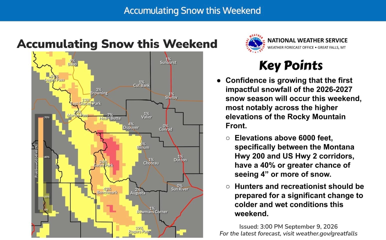
The National Weather Service in Great Falls said Thursday morning that a stronger upper-level system moving into Montana this weekend will bring “well below average temperatures” and enough moisture for widespread mountain snowfall above approximately 7,000 feet. Current NWS forecasts generally keep accumulations below six inches, although some of Montana’s highest terrain has roughly a 10% chance of receiving more than a foot of snow.
That makes this a legitimate candidate for the first impactful mountain snowfall of the 2026–27 ski season in Montana.
Montana Snow Forecast Has Become More Interesting
When we first reported on the developing Montana snow forecast Tuesday, meteorologist Chris Tomer was tracking the potential for roughly 6–10 inches of snow across some of the highest terrain above 7,000 feet.
Two days later, the exact snowfall totals have changed somewhat, but the overall setup has become more credible.
The latest National Weather Service forecast discussion from Great Falls calls for one weather system to arrive Friday, followed by a stronger upper-level low over the weekend.
That second system is the one skiers should be watching.
As colder air settles over the Northern Rockies, snow levels are expected to drop toward 7,000 feet, allowing precipitation that would have fallen as rain just days earlier to change to snow across the high country.
An earlier NWS outlook was even more specific about the Rocky Mountain Front, putting the probability of four inches or more of snow at 40% or greater above 6,000 feet in favored terrain between Montana Highway 200 and U.S. Highway 2.
So while the original 6–10-inch forecast isn’t currently the most likely outcome everywhere, several inches of genuine accumulating September snow now appears increasingly plausible.
Glacier National Park Could Be One Of The Sweet Spots
Northern Montana and the mountains surrounding Glacier National Park remain among the areas to watch most closely.
Forecasts near the Continental Divide show rain transitioning to rain and snow this weekend, particularly Saturday night into Sunday. One NWS point forecast near West Glacier at roughly 6,800 feet calls for rain and snow Sunday with a snow level around 7,300 feet.
That’s notable because some of Glacier’s most famous high-elevation terrain sits right around the expected rain-snow line.
Logan Pass, for example, is at 6,646 feet, according to the National Park Service. That means a difference of only a few degrees could determine whether locations around the pass see cold rain, wet snow or accumulating snow.
Higher peaks surrounding the pass should have a considerably better chance of turning white.
The National Park Service notes that September snow isn’t particularly unusual in Glacier. Snow can occur at lower elevations as early as mid-September, and conditions can change rapidly in the high country.
Big Sky’s Upper Mountain Is High Enough For Snow
Farther south, Big Sky Resort also bears watching.
The town and lower mountain could stay mostly wet, but Big Sky’s enormous vertical range gives it much higher terrain to work with.
Big Sky Resort lists its Mountain Village base at 7,500 feet and the summit of Lone Peak at 11,166 feet.
The NWS forecast for Big Sky itself currently calls for rain possibly mixing with snow Sunday morning and again Sunday night, with temperatures near freezing overnight.
Conditions thousands of feet higher on Lone Peak could obviously be much colder.
So even if Big Sky’s base remains relatively snow-free, seeing the upper mountain plastered white by the end of the weekend would not be surprising if the storm evolves as currently forecast.
The Beartooths Could Get In On It Too
The Absaroka-Beartooth Mountains are another area worth watching as colder air spreads across Montana.
The National Weather Service in Billings is forecasting a major pattern change beginning Friday, with cooler temperatures and multiple chances for precipitation through the weekend. Forecasts for the Absaroka-Beartooth Mountains show overnight temperatures dropping toward freezing as the system moves through.
The highest peaks in the Beartooths extend well above 10,000 feet, putting them comfortably above the projected snow line.
If precipitation lines up with the coldest air, the Beartooths could emerge from the weekend looking much more like October than mid-September.
Is This Really The First Snowstorm Of The Ski Season?
That really all depends on what you consider a snowstorm. High peaks across the Rockies can pick up brief snow at almost any time of year, and a dusting in September isn’t especially unusual. But this system looks different.
The National Weather Service itself is now describing the event as potentially the first impactful snowfall of the 2026–27 snow season, particularly across the higher elevations of the Rocky Mountain Front.
That’s the important distinction.
We’re not talking about skiing yet, and this certainly isn’t the beginning of a lasting seasonal snowpack. Ground temperatures remain warm, September sunshine is still powerful and much of whatever falls will probably melt quickly.
But several inches of accumulation across broad areas of high terrain would mark a very real seasonal milestone.
For skiers and snowboarders, it’s the first unmistakable sign that winter isn’t all that far away.
How Much Snow Could Actually Fall?
For now, under six inches is the best broad expectation for most of the affected high terrain, based on the latest NWS Great Falls guidance.
But there is meaningful upside.
The NWS says some of the highest terrain still carries roughly a 10% probability of exceeding 12 inches over the weekend.
That’s not a prediction of a foot of snow. It’s an indication that the colder and snowier end of the forecast envelope remains possible. And mountain snowfall forecasts this early in the season are particularly sensitive to temperature.
If snow levels stay closer to 8,000 feet, accumulation will be confined mainly to the alpine. If they fall below 7,000 feet for a sustained period, considerably more visible terrain could turn white.
Either way, Montana appears increasingly likely to get its first widespread taste of winter this weekend.
And somewhere high above the valleys, there may be enough fresh snow to make September 13 look suspiciously like ski season.
