
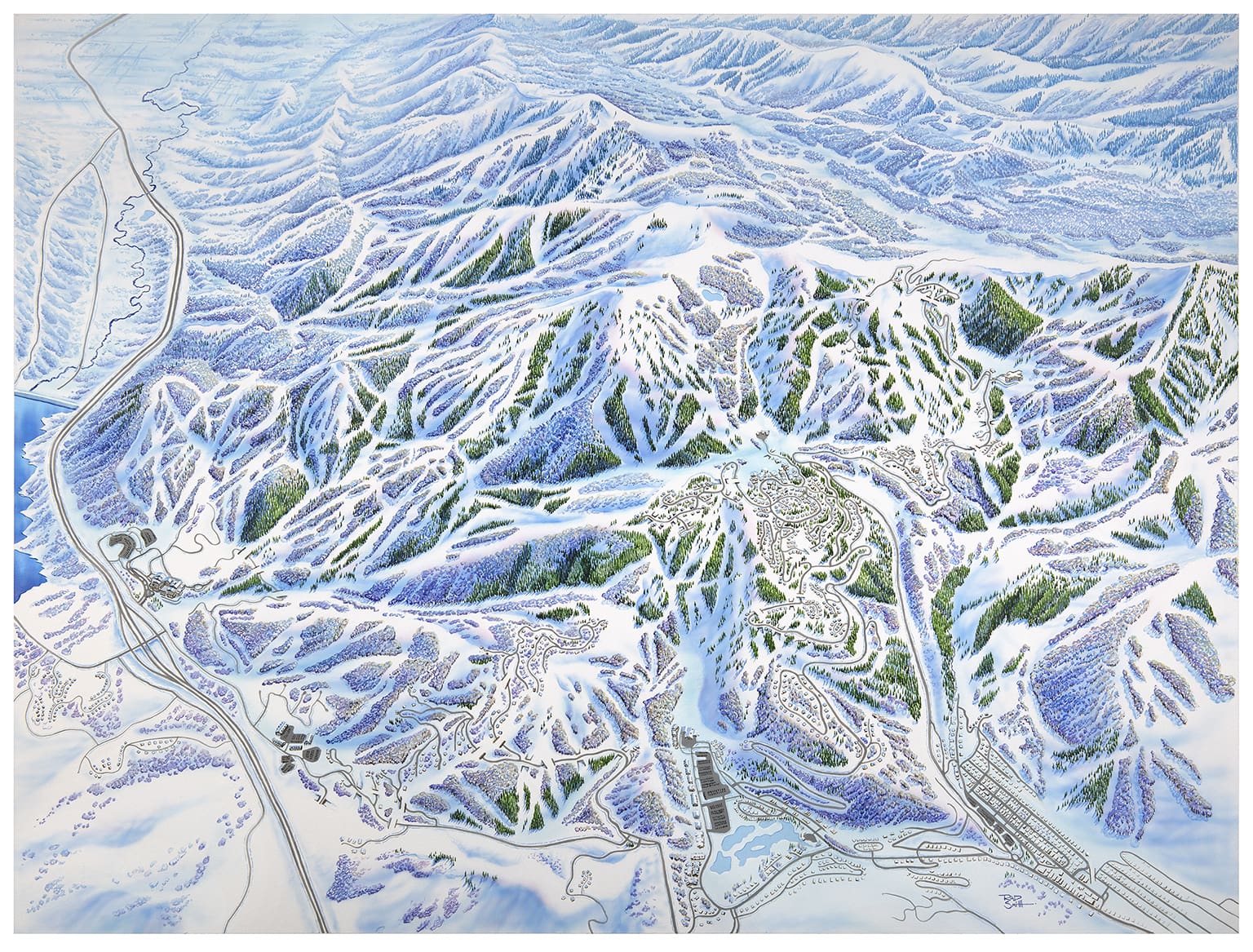
Park City, Utah — This season, Deer Valley Resort will begin a new chapter in its storied history. The Utah ski resort will open the first phase of the East Village expansion this winter. This first phase will add 19 (plus a run extension) trails and three new chairlifts. When completed, the expansion will add 135 new trails and 16 more lifts to Deer Valley. These changes meant that Deer Valley needed a new trail map design. Ultimately, Deer Valley turned to Rad Smith to help display its massive terrain network.
Rad Smith is one of the biggest names in the trail map game, as James Niehues passed the brush to him a few years ago. Rad does a mix of digital and painted maps but has begun focusing on paint-brushing mountains since Niehues retired. Some of his most notable trail map projects include Alta, Aspen Mountain, Big Sky Resort, Big White, and Keystone.
I’ve always been a pretty big fan of trail maps. I’ve been collecting them since I was a young lad, and I have an extensive (perhaps unhealthy) amount of trail maps in my apartment. So I was excited when Deer Valley announced that Rad Smith would redesign their map to include the new terrain that’s part of this Expanded Excellence initiative.
Last month, I had the chance to chat with Rad Smith about this project. We chatted about his creative process and what it took to create such a complicated map. A condensed version of our interview with Rad is below.
How long have you been drawing/painting trail maps? I’ve been drawing (pencil drawing or painting) traditionally since 2007. I did digital trail maps before that, and it was a slow evolutionary process just from my traditional mapping work and getting more involved with ski areas or resort-specific maps.
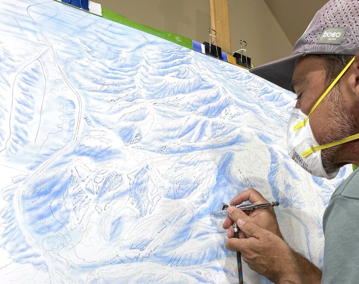
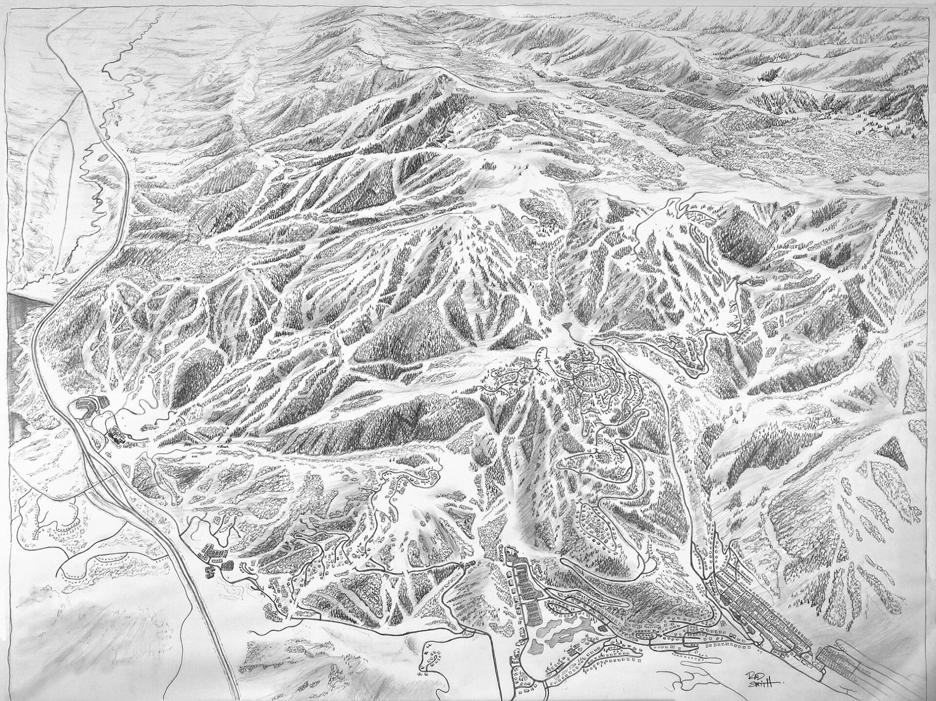
How long did the process of creating this map take? Was it the longest map process that you’ve ever done? I visited Deer Valley in March 2024. It was a start-and-stop process, as I worked on the line draft while I was working on other paintings. There was a pretty lengthy review process for that. It was probably the largest map and longest process regarding my involvement for a trail map. Overall, it took three months of work, but that was spread out over a six-month period.
What was the most difficult part of creating this map compared to other projects? The biggest challenge was the overall physical scope of the area with this expansion. It’s almost more like a regional map because it’s such a big area. The challenge of fitting it in all into the space that I had to paint was the first and foremost challenge. Then, in order to fit that in, I took a higher perspective. Not having a horizon line and a traditional look at the elevation of the mountains was challenging while still trying to show the elevation changes without having that horizon. Being able to see it without seeing it across the valley.
The overall size of that area was challenging, plus the diversity of trees. There are a lot of aspens and evergreens, but there are mature aspens and smaller, brushy-type aspens or alders. In trying to capture that, again, with such a big scope, you can’t put a lot of those details in; you have to generalize a lot. So, you end up working with tree textures more than specific individual trees. Overall, the size was unique to me from a trail map perspective.
What did you do to discover the type of terrain that’s part of this expansion? Going to Deer Valley and spending a couple of days on the mountain. I got to ski that terrain with the ski patrol and some employees. That was really helpful. The biggest thing that I got from there was the change in aspect. Skiing that whole East Village side, I see that it is really a whole different kind of viewscape. Looking down on Jordanelle Reservoir and that area. You can see some of that in the skiing that has existed on Baldy. This terrain really takes a turn from an aspect standpoint, so that was super helpful.
I also looked at existing maps. They had some of their engineering maps that had been created throughout the process that showed where ski runs were going to be cut because some of the aerial imagery that I had was from the previous years. So some runs had not been fully developed yet. Seeing what was slated and what was planned, and then comparing what they had on Google Earth or Fat/Strava Map, and looking at any map resource that I could find was always helpful to see how things have been portrayed in the past or how that terrain looks. The landscape (the hill shapes and slopes) doesn’t change too much; it’s more about cutting trees and creating the ski paths. It’s a combination of all those things to develop as much understanding of the place. Being at the ski area, you get the overall vibe, the feel of the environment, and the way the mountain feels.
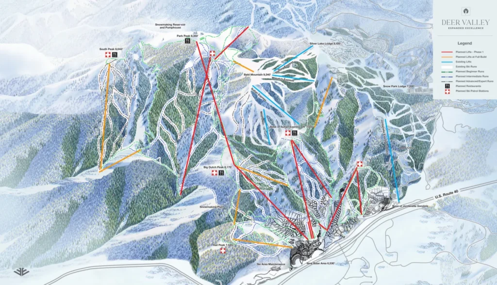
What adjustments need to be made for future seasons? I think we’re pretty set with the artwork for that 2025-26 release, so to speak. However, there will be changes on the map with the labeling to show the trails that come online. We’ve talked about creating additional maps that show some of that additional terrain from a more traditional perspective. That’s one of the more challenging things about a map this size. I’ve certainly had to compromise a lot of that new terrain because it’s in the background. Some of those runs are incredibly long, and I tried to show that, but there’s so much space at the end of the day to fit it all in. It’s a lot easier to show the stuff in the foreground, and it’s a bit truer to scale compared to the mid or background terrain. That’s why I took that higher perspective.
Does a new map have to be created entirely when the new trails are added next winter? No, it doesn’t. There are a few options. One option I can do is go back into the painting, remove pigment, repaint areas, and create new trails. Part of the development of this map was knowing what was coming down the road in terms of what trails were coming in the future and what will be coming online in the next couple of years. So, I try to accommodate all those and present them to some degree. We went back and forth to show them all now, but a lot of it is visible from the road, so a lot of people already know about these trails even though they aren’t accessible this year. We just decided to show everything as it is now, but there are a few sections and runs that I’ve already painted that Deer Valley may be doing some tree cutting next summer. Usually, I try to accommodate trails that will be shown in the future or at least have the space to come back and paint those trails.
How Much Input Did Deer Valley Get In Creating The Trail Map? A lot. I certainly like to have a ski area provide me with as much input as they want to. My three-part process starts with a really basic line draft to show the overall perspective and make sure I’m capturing everything that needs to be shown. There are a lot of opportunities in that step and in the detailed pencil sketch that follows that line draft. Deer Valley has lots of opportunities to say: “Let’s emphasize this; let’s rotate the perspective a little.” There’s a fair bit of that, especially with the length of some of the areas. Really trying to balance this stuff. Once I start painting, I share weekly updates with clients. There are opportunities for them to comment on the colors I choose or anything on the artistic side. Usually, once I start on the painting, everyone has agreed on the overall layout of the artwork.

What’s the favorite map that you’ve done? Honestly, when I’m halfway through a map, I love them. I love seeing a map because I paint it from top to bottom. It’s not like I’m roughing out the whole painting and slowly bringing it to fruition. I actually start from the top and work my way down. So, I really love a project when I’m halfway or two-thirds of the way done. So half of the image is completely done, and half is whiteboard with some pencil marks, kind of showing some of the outline shapes.

I do like the Deer Valley map. It’s probably one of my favorites. It’s fresh on my mind since I just finished it, but it’s also because of some of the challenges I spoke to earlier (the size of it). Plus, Deer Valley has been great to work with. If they decide to do something, they want to do it right, and they take the time to do it right. Their involvement was a great process, and that’s fairly common with ski areas. They love the whole map process. It’s an important piece for them, and they want to invest the time and money that’s necessary to do it right. I love that kind of passion, and Deer Valley has a lot of that. I think that shows in the ski area and the product that they provide. It’s usually on the easel that I like the most. It’s such a weird process because once I’m done with it, I’m moving on to other work, and it’s so neat to see people enjoying the map and I’m reminded of what the purpose of the map actually is.
Click here to check out more of Rad’s trail map artwork.

Image/Video Credits: Rad Smith, Deer Valley Resort