


Everyone’s favorite mountain weather meteorologist Chris Tomer is back with an early season mountain weather forecast. Obviously we’re only just getting into November, so the huge snow totals are probably still a good distance away, but we help getting excited (especially with more and more resorts opening their lifts every day!).
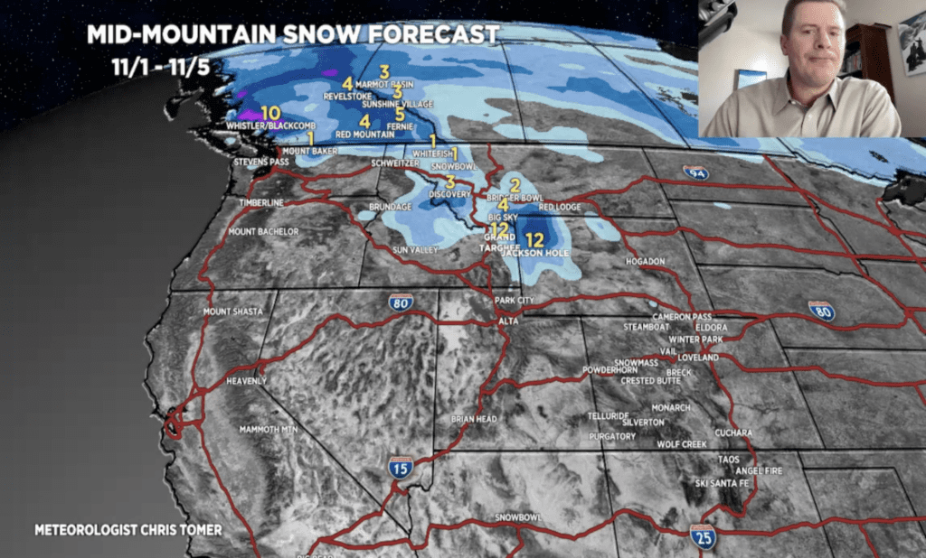
The big winners over the next week and a half (November 1-November 9) are the resorts located in northwest Wyoming, southwest Montana, and southeast Idaho. Grand Targhee could see up to 25 inches of snowfall throughout the next two storm cycles, and Jackson Hole could be sitting just a little bit lower with 22 inches.
As always, this is just a forecast. It’s impossible to say for sure what’ll happen next!
“3 storm systems, 2 AR surges, jet stream and precipitable water, and snow forecast through 11/9.“
Colorado, Utah, and most of the Pacific Coast in the United States is set to receive just about nothing between November 1 and November 5 (darn you Chris Tomer! [obviously this isn’t actually his fault]). The second storm cycle, between the 6th and the 9th, will bring Colorado, Utah, and California just a bit more than nothing! 1-3 inches are possible at many of the northern Colorado and Utah resorts, and the same in California.
Mount Bachelor could see some solid snow come down between the 6th and 9th, possibly reaching a full foot. Our friends north of the border will likely be happy to hear that Whistler could receive a total of twenty inches throughout the next nine days.
East coasters, winter just isn’t headed your way quite yet. You’ll just have to be a bit more patient than you’d probably like for now… sorry.
Related: Chris Tomer’s Official Winter Weather Forecast For 2023/2024
Image Credit: Chris Tomer via YouTube