
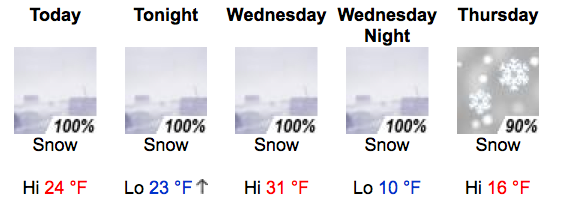

If you’re wondering where the snow is, it’s in Jackson. The forecasted storm came in with a bang last night, depositing about a foot of fresh overnight, compared to the 3″ to 6″ that were forecasted. The snow was extremely low density, with only 0.40″ of water accompanying it. NOAA is predicting 30″ to 40″ by tomorrow morning, with locally higher amounts. Also notable are the high westerly winds accompany this system. Overnight, wind exceeded 50MPH on top of the tram, and forecasters are calling for winds in excess of 90MPH in the next 24 hours.
So what does this all mean? First and foremost, increased avalanche danger. The new snow will fall on about two feet of of low density snow, stressing the snowpack. Please consult the Bridger-Teton Avalanche Center for advisories. Second, it means blower pow. Really, blower pow. So far, the storm is producing extremely light snow, although temperatures are supposed to rise. So get out there, use good decision making, and enjoy some of the best snow so far this year! SFO-JAC flights are $473-just sayin’.