

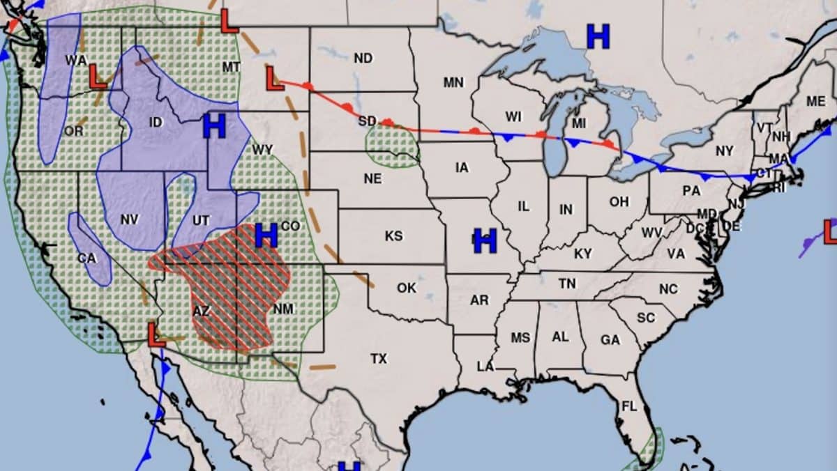
A powerful Pacific storm is approaching the western United States, bringing widespread precipitation, gusty winds and accumulating mountain snow from California to the Rockies between Wednesday, October 21, and Saturday, October 24. Some of the highest peaks in the Sierra Nevada could receive more than 8 inches of snow, while ski resorts in southwestern Colorado, Utah and Montana are also positioned for fresh snowfall as the storm moves inland.
The system is expected to bring significant precipitation to California on Wednesday and Thursday before spreading into the Intermountain West. However, unusually warm temperatures will play a major role in determining which ski resorts receive accumulating snow and which see mostly rain.
According to the NOAA Weather Prediction Center’s October 20 forecast, the southern Sierra Nevada has a 40% to 70% probability of receiving more than 8 inches of snow above 10,000 feet by Thursday night. The probability of more than 12 inches is considerably lower, between 10% and 30%.
Farther east, southwestern Colorado could receive some of the heaviest precipitation from the storm, but high snow levels may keep much of it falling as rain until colder air arrives later in the week.
Mammoth Mountain Among California’s Best Bets for Snow
California’s Sierra Nevada will be one of the first major ski regions affected, with precipitation developing Wednesday morning and continuing through Thursday.
Mammoth Mountain stands out because of its 11,053-foot summit, which extends well above the elevation where the National Weather Service expects the heaviest snowfall.
The Weather Prediction Center expects the heaviest snowfall to remain above 10,000 feet, with 3 to 6 inches possible as low as 9,000 feet on Wednesday and Thursday. Forecasters estimate a 40% to 70% chance of more than 8 inches above 10,000 feet, putting Mammoth Mountain’s upper slopes in a favorable position for accumulating snow while lower elevations could receive a mixture of rain and snow.
The National Weather Service office in Hanford also reports a 55% to 70% probability of at least 4 inches of snow above 8,000 feet in the southern Sierra, with a 50% to 65% chance of at least 6 inches above 10,000 feet.
Those projections are regional high-elevation forecasts rather than guaranteed totals for Mammoth’s individual lifts or base areas. Snowfall amounts will depend on elevation, precipitation intensity and how quickly colder temperatures arrive.
Nearby June Mountain could also receive snow at higher elevations, although reliable resort-specific accumulation totals have not been established.
Farther north, Lake Tahoe resorts including Palisades Tahoe, Kirkwood and Heavenly could see snow at higher elevations, but the strongest snowfall signal in the current National Weather Service outlook is concentrated farther south.
For California ski areas, Wednesday afternoon through Thursday appears to offer the best opportunity for accumulating snow from the initial storm.
Silverton and Colorado’s San Juan Mountains Could See Significant High-Elevation Snow
Southwestern Colorado is another region worth watching closely, with substantial precipitation expected from Wednesday through Friday.
The National Weather Service in Grand Junction expects between 1 and 3 inches of total precipitation across portions of the southern Colorado mountains, with 2 to 4 inches or more possible in the San Juans and southern foothills.
However, the storm is arriving with unusually warm air, potentially keeping snow levels above 12,000 to 13,000 feet during much of the event.
Those elevations are important because many Colorado ski resorts have summit elevations below 13,000 feet. Heavy precipitation does not necessarily translate into heavy snowfall when temperatures remain too warm.
Silverton Mountain, whose terrain extends above 13,000 feet, remains one of the more promising ski areas for accumulating snow. However, rain could fall across substantial portions of the mountain, and reliable summit snowfall totals have not yet been established.
Telluride and Crested Butte could also see precipitation as the storm moves into Colorado, although significant snowfall at resort elevations is uncertain. Much of the initial precipitation could fall as rain, with accumulating snow primarily confined to their highest terrain.
Colder conditions later in the week could improve snowfall chances. The Grand Junction forecast office expects another period of mountain snow during the weekend, potentially reaching elevations above approximately 10,000 feet as a separate low-pressure system moves inland.
Ski resorts along the Interstate 70 corridor, including Breckenridge, Copper Mountain and Arapahoe Basin, could also receive snow as temperatures fall, but the National Weather Service has not established reliable resort-specific accumulation totals.
The more immediate concern in southwestern Colorado is flooding. Heavy rainfall, combined with melting snow from previous storms, could produce excessive runoff and dangerous conditions along mountain roads and waterways.
Big Sky Could See Accumulating Snow as Colder Air Arrives
Montana’s ski resorts are expected to remain relatively dry through much of Wednesday and Thursday before a colder storm system arrives late Thursday into Friday.
Big Sky Resort is among the mountains that could receive accumulating snow as the system moves into the northern Rockies.
The National Weather Service in Great Falls expects rain and mountain snow to spread across the region Friday, October 23, and continue into early Saturday, with accumulating snowfall possible above approximately 4,000 feet.
The NWS forecast for the Big Sky area calls for rain transitioning to a mixture of rain and snow Friday before changing to snow Friday night.
The resort’s upper elevations could see snow earlier than its Mountain Village base area, although reliable resort-specific accumulation totals are not yet available.
Other northern Rockies destinations, including Bridger Bowl, could also receive snowfall as temperatures fall, with the greatest potential for accumulation at higher elevations.
Utah Ski Resorts Could See Snow on Friday
Utah’s ski resorts could receive fresh snow late this week as the Pacific storm spreads precipitation across the state.
According to the National Weather Service in Salt Lake City, widespread precipitation is expected to develop across southern Utah on Wednesday, October 21, before expanding northward through Friday.
The storm will initially bring relatively warm conditions, with rain possible at lower elevations before colder air arrives. The National Weather Service is forecasting approximately 3 to 6 inches of snow across northern and central Utah’s highest terrain on Friday, primarily above 9,000 feet, with locally higher amounts possible.
That puts the upper elevations of Alta, Snowbird, Brighton and Solitude in a favorable position for accumulating snow, particularly Thursday night into Friday. Lower portions of the resorts could receive a mixture of rain and snow depending on how quickly temperatures fall.
Park City Mountain could also receive snow across its highest terrain, although its lower elevations are more likely to experience rain during the warmer portion of the storm.
While several Utah resorts could receive measurable snowfall, the current forecast favors modest accumulations rather than a major early-season snowstorm. The heaviest precipitation across southern and central Utah is expected to fall primarily as rain, where forecasters are also warning of localized flooding.
Another Pacific Storm Could Affect the Northwest This Weekend
The Pacific Northwest is expected to avoid the heaviest precipitation from the initial storm, which will concentrate much of its moisture across California and the Southwest.
According to the National Weather Service in Portland, Oregon will remain largely dry through Wednesday, with above-average temperatures early in the week. Cooler conditions and a chance of precipitation return Thursday into Friday, although forecasters are not expecting significant rainfall from that initial disturbance.
That means ski resorts including Mount Bachelor and Timberline are not currently positioned for the largest snowfall accumulations from the first system.
A potentially stronger Pacific disturbance could approach the Northwest over the weekend. However, considerable uncertainty remains regarding its strength and track, with some forecast scenarios keeping the storm’s center offshore and limiting precipitation.
Farther north, the National Weather Service in Seattle identifies Saturday night into Sunday morning as a possible period for another frontal system to bring precipitation into western Washington.
Crystal Mountain and other Cascade ski areas could receive mountain snow if temperatures and snow levels fall sufficiently, but meaningful accumulation totals have not yet been established.
The NOAA Weather Prediction Center’s October 20 extended forecast also identifies another Pacific disturbance approaching the Northwest between October 23 and 27, bringing additional precipitation opportunities.
For now, the strongest near-term snowfall potential appears concentrated in the upper elevations of California’s southern Sierra Nevada on Wednesday and Thursday. Montana and northern Utah could also receive accumulating snow Friday, while significant precipitation in Colorado’s San Juan Mountains may fall as rain below the highest terrain.
The biggest uncertainty is how much of the expected precipitation will actually fall as snow at ski resort elevations. With relatively warm air accompanying the initial storm, some mountains could receive substantial precipitation without developing a significant snowpack.
Although fresh October snowfall is encouraging for resorts preparing for the 2026-27 season, additional storms and sustained cold temperatures will be needed before most Western resorts can begin opening terrain.
