

A massive glacier collapse high in the Himalayas appears to have triggered the catastrophic flooding that swept through parts of Nepal and Tibet on August 26, 2026, sending a wall of water, ice, rock and mud racing through mountain valleys.
The disaster initially caused confusion among scientists and officials because seismic instruments detected what appeared to be an earthquake around the time the flooding began. But investigators now believe the sequence happened the other way around: the collapse of an enormous mass of glacier ice and rock generated the seismic signal and set off the deadly flood.
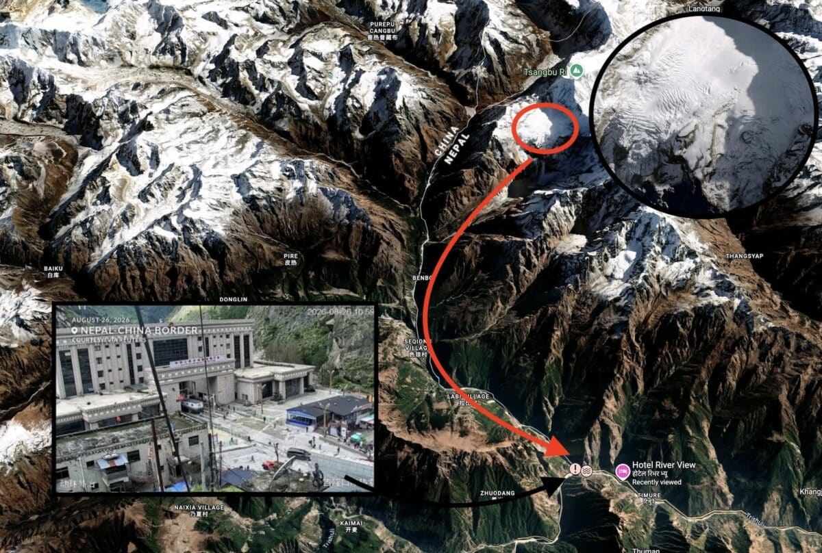
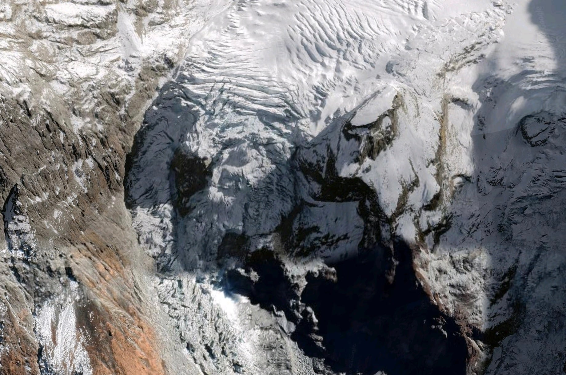
Satellite imagery indicates that a substantial section of a glacier near the Lhende River along the Nepal-China border suddenly detached from the mountainside. The falling ice and rock plunged roughly 3,900 vertical feet (1,200 meters) before slamming into the valley below.
The resulting avalanche temporarily blocked the river. When that unstable natural dam failed, an enormous surge of water and debris was released downstream.
The event provides a dramatic example of how quickly hazards can cascade in high mountain environments: glacier collapse → ice-and-rock avalanche → river blockage → dam failure → catastrophic flash flood.
Which Glacier Collapsed?
One important detail remains unclear.
As of August 27, the glacier involved in the disaster does not appear to have a widely recognized or officially reported name in the international coverage of the event.
It is located high above the Lhende River, or Lhende Khola, near the Nepal-Tibet border, roughly 12 miles northeast of the Rasuwagadhi/Gyirong border crossing.
Some early reports have simply referred to it as the Lhende glacier because of its location within the Lhende watershed, but that should not yet be treated as a confirmed formal glacier name.
According to reporting based on Planet Labs satellite imagery, a large section near the lower end of the glacier broke loose at approximately 17,000 feet above sea level.
The mass then fell roughly 3,900 feet onto the valley floor.
What Actually Happened?
The disaster wasn’t a traditional flood caused by days of heavy rain.
In fact, the absence of significant rainfall was one of the first indications that something unusual had happened high in the mountains.
Satellite analysis showed a huge scar where part of the glacier and surrounding mountainside had apparently detached.
The material accelerated downhill as an ice-rock avalanche, picking up additional sediment, boulders and debris along the way.
When it reached the Lhende River, the avalanche appears to have temporarily blocked the channel.
Water accumulated behind that obstruction until the natural dam failed.
The resulting surge raced into the Bhote Koshi and Trishuli river systems, reportedly causing the Trishuli River to rise by as much as 27 feet in approximately 30 minutes in some areas.
Entire communities and infrastructure downstream were overwhelmed by the muddy torrent.
As rescue operations continued Thursday, casualty and missing-person figures were changing rapidly. Hundreds had been reported dead and many more remained missing across Nepal and Tibet.
Did An Earthquake Cause The Glacier To Collapse?
That was one of the first theories.
A seismic event initially reported at around magnitude 4.4 occurred close to the time of the disaster, raising the possibility that an earthquake destabilized the glacier.
Subsequent analysis, however, pointed toward a very different explanation.
The U.S. Geological Survey determined that the seismic signal was generated by the enormous landslide and glacier collapse itself, rather than an earthquake triggering the collapse.
In other words, the mountain moving was powerful enough to register on seismic monitoring equipment.
The landslide was ultimately reported as producing a seismic event equivalent to approximately magnitude 5.2.
That distinction matters because it suggests that the glacier may have failed without an obvious external trigger such as a major earthquake or extreme rainstorm.
Why Did The Glacier Collapse?
Scientists will likely need considerably more time and satellite analysis before they can identify the precise cause.
Glaciers are constantly moving under their own enormous weight. When ice sits on steep terrain, relatively small changes in temperature, meltwater, the underlying rock or the glacier’s internal structure can dramatically alter its stability.
Several mechanisms may have contributed.
Meltwater Can Lubricate A Glacier From Below
During periods of warm weather, meltwater can travel through cracks and channels in a glacier and reach the boundary between the ice and underlying rock.
That water can reduce friction beneath the glacier.
On a steep mountainside, even a relatively small reduction in friction can allow a huge amount of ice to accelerate or detach.
Thawing Permafrost Can Destabilize Mountain Slopes
At extremely high elevations, permanently frozen rock and soil can effectively act like cement holding mountain slopes together.
When that permafrost begins thawing, cracks can open and rock faces can become increasingly unstable.
A collapsing rock slope can destabilize glacier ice sitting above or alongside it, creating the kind of combined rock-and-ice avalanche seen in this disaster.
Retreating Glaciers Can Become Structurally Unstable
As glaciers lose ice, their geometry changes.
Sections that were once supported by surrounding ice may become exposed. Steep glacier fronts can become thinner and fractured while surrounding slopes lose the structural support previously provided by the glacier.
Eventually gravity wins.
The result can be the sudden detachment of millions of tons of ice and rock.
Is Climate Change Responsible?
Scientists should be cautious about attributing one specific glacier collapse entirely to climate change before detailed research is completed.
But the broader trend occurring throughout the Himalayas is much clearer.
The Hindu Kush Himalaya is undergoing rapid glacier loss, warming and permafrost degradation, all of which can increase the potential for cascading mountain hazards.
The International Centre for Integrated Mountain Development reported in March 2026 that glacier ice-loss rates across the Hindu Kush Himalaya have roughly doubled since 2000.
Earlier research from ICIMOD found that glaciers in the region disappeared 65% faster between 2011 and 2020 than during the previous decade.
Researchers have also warned that shrinking glaciers and thawing permafrost can contribute to more landslides, unstable slopes and potentially dangerous glacial lakes.
So while scientists have not yet established exactly why this particular glacier failed on August 26, it occurred within a mountain system that is changing rapidly.
Glacier Collapses Are Different From Normal Avalanches
Most skiers and mountaineers are familiar with snow avalanches.
A glacier collapse operates on an entirely different scale.
Instead of relatively loose seasonal snow sliding down a slope, a glacier failure can involve millions of cubic meters of dense ice, rock and water.
Once that mass begins moving down a steep mountain, it can reach tremendous speeds.
The avalanche can also pick up additional rock and sediment along the way, transforming into a highly mobile debris flow.
When one of these events interacts with a river or glacial lake, the consequences can become even larger.
A similar chain reaction occurred during a 2020 glacier collapse near Machu Picchu in Peru, where approximately 400,000 cubic meters of ice and rock reportedly fell into a lagoon and produced destructive flooding downstream.
Unofficial Networks covered that glacier collapse here.
The Biggest Danger May Be What Happens After The Ice Falls
One of the most important aspects of the Nepal-Tibet disaster is that the initial glacier collapse wasn’t necessarily the most destructive portion of the event.
It was what happened next.
When an avalanche blocks a river, it can create an accidental dam made from loose ice, rock and mud.
Unlike an engineered dam, there is little holding that material together.
Water continues accumulating upstream until it either flows over the obstruction or forces its way through it.
When the blockage fails, the stored water can be released almost instantly.
The process resembles a glacial lake outburst flood, or GLOF, where water stored behind ice or glacial sediment suddenly escapes.
Unofficial Networks recently covered another potentially dangerous glacial outburst situation at Place Glacier in British Columbia, where officials issued evacuation alerts after a glacial lake reached levels comparable to those preceding a previous flood.
Read: Glacial Lake Outburst Threat Prompts Evacuation Alerts In British Columbia
The U.S. Geological Survey has documented how glacial lake outburst floods in Tibet can transform into destructive debris flows as floodwater collects loose sediment while racing through steep mountain channels.
Why Himalayan Communities Are Particularly Vulnerable
The Himalayas contain some of the steepest terrain and largest concentrations of mountain ice on Earth.
They also contain countless communities, roads, bridges and hydroelectric facilities built along narrow river valleys.
That combination creates an enormous risk.
A glacier can fail miles away and thousands of vertical feet above a populated area, yet the flood generated by that collapse can reach downstream communities incredibly quickly.
In some situations there may be only minutes between the first signs of an event and the arrival of destructive floodwaters.
And because many Himalayan valleys have limited road access, rescue operations become extraordinarily difficult once bridges and highways are destroyed.
A Growing Mountain Hazard
Glacial lake outburst floods have been studied for decades, but large-scale glacier detachments remain comparatively rare and difficult to predict.
That may become an increasingly important area of mountain hazard research.
Warmer temperatures are changing glaciers and permafrost in high mountain ranges from the Himalayas to the Alps, Andes, Alaska and western North America.
That doesn’t mean every glacier is suddenly at risk of collapsing.
But it does mean some mountain landscapes are entering conditions that have not existed for hundreds or even thousands of years.
The August 26 disaster on the Nepal-Tibet border demonstrates just how quickly one failure high in a remote mountain valley can develop into a catastrophe dozens or even hundreds of miles downstream.
The glacier itself may have collapsed in seconds.
The consequences will last much longer.