

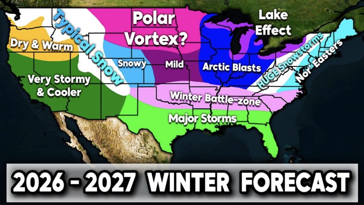
Direct Weather has released its preliminary forecast for the 2026-2027 winter season, pointing to a sharp divide in weather patterns across the United States. According to the long range outlook, a strong El Niño could fuel an active southern storm track that favors heavy precipitation and increased snowfall across parts of the Southwest and East while leaving the Pacific Northwest and Northern Plains warmer and drier than normal.
Seasonal forecasts can change as winter approaches, but Direct Weather says the expected El Niño pattern is the primary driver behind its early outlook. Here is a region by region breakdown of the forecast.
Pacific Northwest
- Warmer than normal temperatures are expected through much of the winter.
- Below average precipitation is forecast because of a less active northern storm track.
- Snowfall chances are expected to run below normal across many mountain ranges.
Southwest
- Cooler than normal conditions are forecast, largely because of persistent storm systems and cloud cover.
- Above average precipitation is expected across California, Nevada, Arizona, New Mexico, and the Four Corners region.
- The Sierra Nevada carries the highest confidence for above average snowfall, making it one of the strongest snow signals in the forecast.
Rocky Mountains
- Conditions are expected to vary from north to south.
- Northern portions of the Rockies could see below average snowfall because of the warmer pattern farther north.
- Southern Colorado, Arizona, and New Mexico have a greater chance of frequent snowstorms and above average snowfall.
Northern Plains
- Above normal temperatures are favored for much of the season.
- Drier than average conditions are expected.
- Snowfall chances are forecast to remain below normal, though brief Arctic outbreaks are still possible.
Midwest And Great Lakes
- Temperatures may swing between mild Pacific air and periodic Arctic blasts.
- Lake effect snow could become a major factor if cold air moves across the unusually warm Great Lakes early in the winter.
- Winter conditions are expected to fluctuate throughout the season.
Ohio Valley
- Cooler than normal temperatures are favored.
- Frequent intrusions of Arctic air could produce several cold stretches.
- Storm systems may bring rain, snow, or ice depending on temperature profiles.
Deep South
- One of the most active storm tracks in the country is expected.
- Above average precipitation is forecast across much of the region.
- Severe weather could become more common than usual during the winter months.
- Rare snowfall events remain possible if strong storms coincide with Arctic air.
Appalachians
- Frequent winter storms are expected throughout the season.
- Interior mountain locations have an increased chance of above average snowfall.
- Strong coastal storms could deliver several significant snow events.
Mid Atlantic And Northeast
- Cooler than normal temperatures are forecast overall.
- An active Nor’easter pattern could produce multiple impactful winter storms.
- Interior locations have an increased chance of above average snowfall.
- Coastal communities could experience a mix of heavy rain, snow, and strong winds depending on storm tracks.
Direct Weather emphasized that this is an early seasonal outlook and additional updates will likely be released as atmospheric patterns become clearer during the fall. Even so, the preliminary forecast suggests the 2026 to 2027 winter could feature major regional contrasts, with the best prospects for heavy snowfall centered on the Sierra Nevada, southern Rockies, the Appalachians, and parts of the eastern United States.
