


The ski season has been off to a miserable start across most of North America, with ski resorts struggling to open a majority of their terrain. However, there could be light at the end of the tunnel. Powderchasers is now saying that one to two feet is possible in the next week, with many regions getting in on the action. The official forecast from Powderchasers is below.
Post via Powderchasers
Powder Watch-1-2 Feet Possible In The Next 7 Days For The West
Powder synopsis:
The next 7 days will bring another teaser to the Sierra midweek, albeit higher totals than the last weak storm. A stronger and colder system will overspread coastal BC and the PNW by Friday/Saturday dropping south over the Sierra early this weekend. Later in the weekend (January 6-7), snow will overspread the southern and central Rockies. There is model discrepancy with some showing higher totals north into the Wasatch and even the Tetons with others keeping higher totals over Arizona and the 4 corners. 2024 is coming in with some good news!
Forecast
Happy New Year everyone! After an endless amount of days watching high pressure and the Sierra getting teased last week (Heavy moisture along the coast with southerly winds avoiding most ski areas), there is a better chance of some moderate snow midweek in California. A stronger system moves in for the weekend.
Below: A Midweek storm sends moderate snow Wednesday into the Sierra with scraps further north into the Cascades. Southerly winds might keep totals in the Sierra in the moderate range (3-8). This storm should outperform the last with colder temps.

The biggest news is a strong low-pressure system we talked about last week pushing into BC and the PNW with colder temps and ample moisture later this week. This system will push south into the Sierra before tracking south into Arizona. Models disagree on how much moisture spreads north into the Rockies with most suggesting impacts extending north into the Wasatch Range. There are significant model differences.
The American Model (GFS) takes the track further south with significant accumulations for the Arizona Snowbowl (They have only had 23 inches all season) with the southern and central Rockies favored (4 corners). The European deterministic model shows a more northerly track with double digits possible for the Wasatch extending into the Tetons and most of Idaho and northern Montana.
Bottom Line: Current confidence is high for double-digit snowfall for the Cascades Friday night to Saturday, a moderate dump for Whistler (5-10), and a decent event for the Sierra (Double Digits) this weekend. High confidence also exists for the 4 corners. Moderate confidence exists for double digits in the Wasatch by Sunday. The Tetons and the majority of Idaho including northern Montana will do well if the European solution holds up. I also have high confidence in at least moderate snow for the Sandpoint Region near Selkirk Powder Guides extending into Whitefish this weekend.
Selkirk Powder Guides is in their 21st year of Cat Skiing situated in northern Idaho. They offer advanced and entry level Avalanche Courses and fantastic backcountry skiing. They expanded their terrain by 6,000 acres this season (All new terrain). Please check out Selkirk Powder Here. They should benefit from the weekend storm. They still have seats available.
Below: The American Model below shows double digits for the entire Cascade Range from Washington to Oregon including western BC Friday night to Saturday. The European model is a bit less optimistic for Whistler and more bullish for northern Idaho as ample moisture works into Idaho, northern Montana, Wyoming, and northern Utah. These totals 5 days out might be a bit too optimistic for the PNW, but we are confident in some decent numbers.

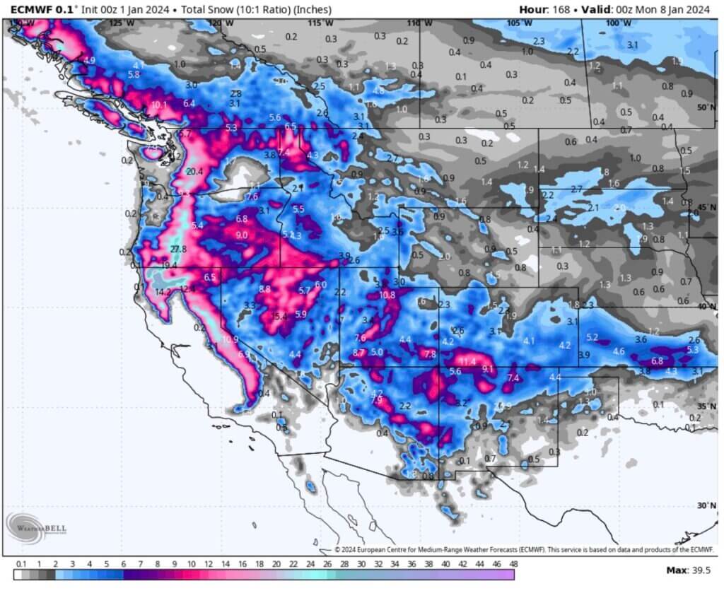
Below: Total snowfall through 5 PM Sunday (January 7) with a high likelihood of double digits from the Cascades to the Sierra per the GFS American Model. This is a bullish solution for the 4 corners, especially Arizona which has been skunked in many storms. Southern Utah and Colorado will also score here.

Below: Map: Total snowfall through 5 PM Sunday- The European solution is more bullish for higher totals further north including the Tetons, Wasatch, and most of northern Idaho and Montana. We still have 5 days to sort out the track so we are not buying into either solution just yet. High confidence for the Sierra and Cascades with totals TBD elsewhere. Totals will also be adjusted as we get closer.
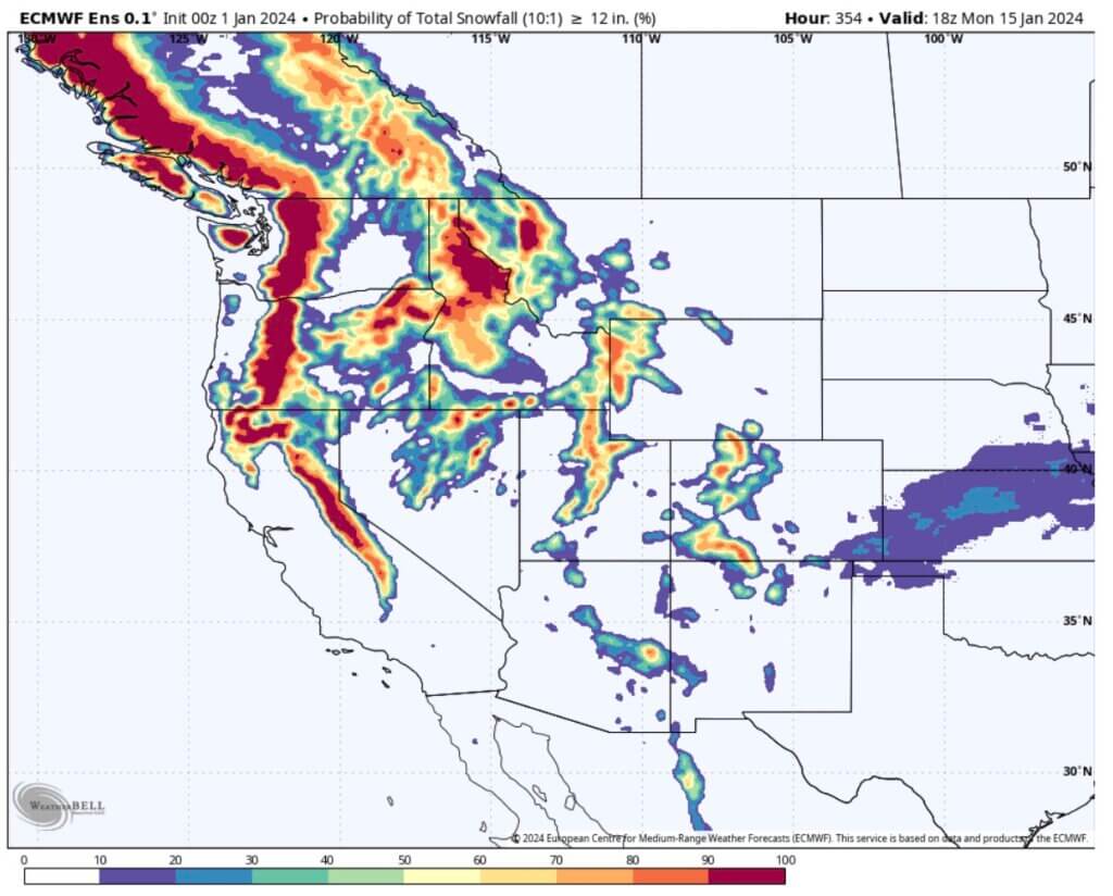
Below: The European solution probability of an excess of 12 inches this week is high for many areas of the west including the northern Rockies (Weekly totals). We are too far out to buy into this solution yet.
Below: The American GFS has a higher emphasis on a southerly track. This map is for a probability of 6 inches or more through Sunday night favoring the 4 corners track including Arizona (Less in the Tetons or central Montana or western Idaho). In this solution, the 4 corners will see significant snow.

Below: The American model with a more southerly track is showing double digits for the Arizona Snowbowl by late Sunday, January 7th. I have decent confidence currently. The European model has a more northerly track. These totals will need to be adjusted as we get closer.

Extended Pow
The pattern stays active into the 2nd week of January with another low expected to move onshore in the PNW by Monday or Tuesday,January 9-11
Below: January 9-11 brings another low-pressure system into the west with a continued trend for storminess. You can see our weekend storm moving into New England by early or the middle of next week with another trough entering the PNW with a similar track as the preceding event.

Help us out!
If you want to chase powder with Powderchasers sign up for the concierge package for the deepest resorts to chase to and 1:1 custom forecasting with our staff. Also, if you have read this far, please donate for the holidays to continue receiving these free forecasts. We appreciate the community support. You won’t regret chasing with our custom forecasts.
Follow us on Instagram and Facebook @powderchasers
Powderchaser Steve @powderchasersteve – Instagram
Powderchaser Steve

Image Credits: Powderchasers, Sundial Hotel