
After a snowy week in the Canadian Rockies, the US is about to see another round of snowfall. Months away from a historic winter, California will see its first snowfall of this fall. In addition, multiple spots in the Central Rockies will see measurable snowfall.
The latest forecast from Powderchasers is below.
First Snow For California- Lots Of Moisture For The Central Rockies
Fall is in full bloom in many areas of the Rockies this week. Reports from Aspen are “it is changing fast” from Mike Faas. Here in Utah where I am located the reds are at peak with the yellows quickly coming out.
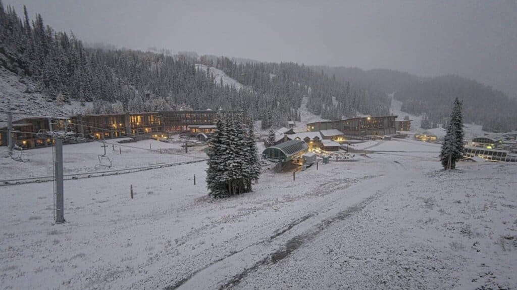
Below: Powderchaser Steve riding Emigration Canyon near Park City on Thursday evening. @powderchasersteve via Instagram.

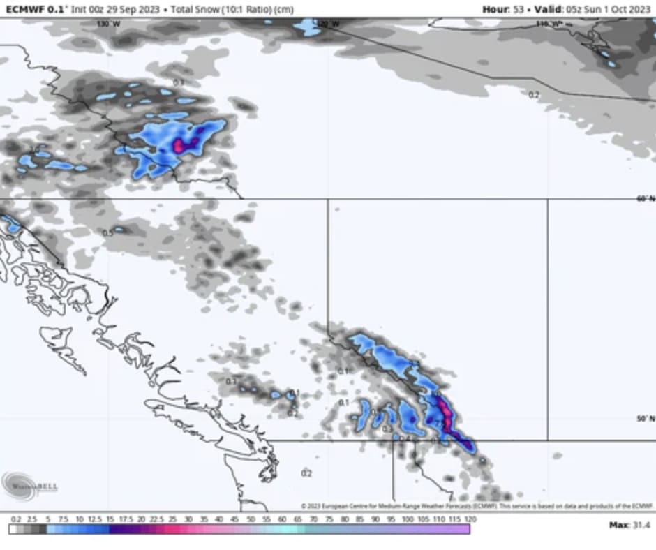
The pattern over the next several days will bring a cold front from Canada into the Intermountain West beginning Friday. The Alberta mountains and perhaps SE corner of BC will fare the best with snowfall falling at upper elevations through Saturday morning. Banff Sunshine with the higher elevations might grab some moderate freshies with rain noted at lower elevation resorts.
Below: The Alberta peaks of Canada are favored with this cold front but only at upper elevations. Cold air will drop south towards the Sierra Friday night.
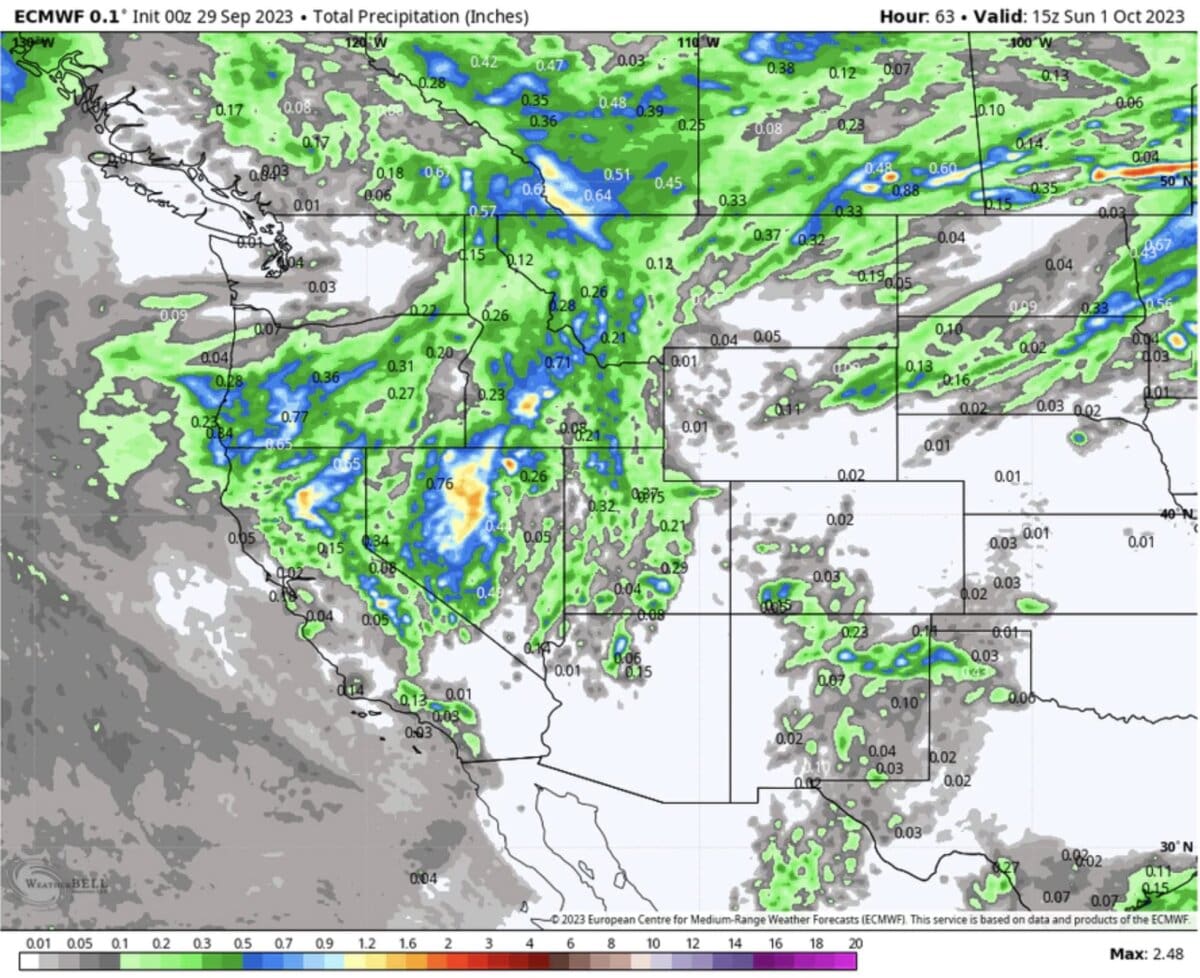
Colder temps will plunge south over the Sierra Friday night into Saturday. The current models show an emphasis on southern regions south of the Lake towards Mammoth or perhaps even further east (Nevada line). Areas north, towards Lake Tahoe will see a few inches at upper elevations, while areas south could see higher amounts (4-8 at the peaks or over 8500 feet). If it were mid-winter would be aiming for southern areas of the Sierra. The models are not in agreement with a slight downward trend in totals. Mid or lower elevations will likely see rain.
Below: Snowfall totals favoring areas well south of the lake (Mammoth or perhaps even further south or east). Hey, it’s a bit of stoke for the upcoming winter! Actual moisture will be healthy and well-needed.

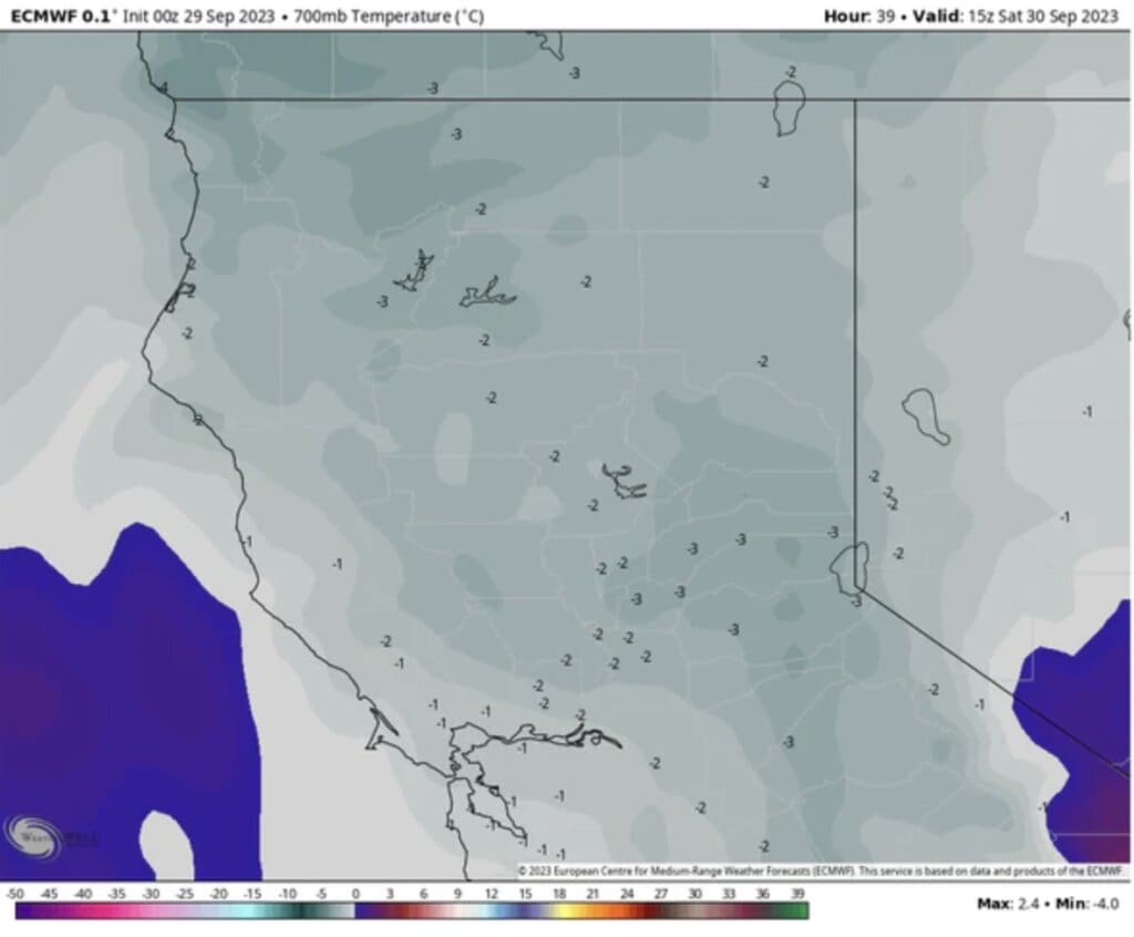
Below Saturday morning temps in the Sierra bring snow levels down to 7500 to 8,000 feet (Map- -3C at 10K or 26F). Moisture will be isolated up north with perhaps higher totals further south towards Mammoth or even further east. The highest totals will be above 9,000 feet.
The bulk of moisture, which will be heavy at times, is aimed at central Nevada (Maybe the Ruby’s get lucky), and the northern Wasatch. Some decent totals are also noted in southern Idaho. Temps will keep snow levels around 9-10K in Utah, initially (Upper peaks of the Cottonwoods) before lowering Sunday night into Monday. The coldest air will reach Utah late Sunday. Your best chances of seeing lower-elevation flakes will be Monday morning in the Cottonwoods.
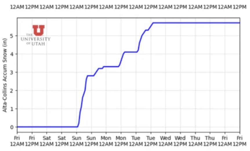
Below: The University of Utah model based on the GFS only shows peak snowfall for Alta from late Sunday to Monday (3-5) as the cold front approaches. Winds will shift from gusty S, SW to NW so it’s possible orographic pump out higher amounts than this model is eluding to Monday morning as some snow continues. The summit of Snowbird, Solitude, Brighton, and Alta might end up grabbing deeper totals.
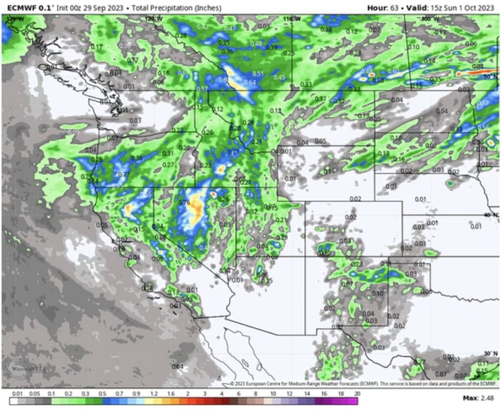
Below: Very healthy moisture totals through Sunday are noted for extreme northern CA, Southern Sierra, central Nevada, and the northern Wasatch. The action fades a bit as you head east into Colorado, however, a secondary low will keep rain and some snow showers near the Front Range in the extended.
Below: Monday morning will see the coldest temps reaching 28 degrees at 10K feet driving snow down to 8,000 feet (Bases of the Cottonwoods). Most of the accumulation will be found at upper elevations. NW flow over northern Utah might keep snow showers going on Monday with an upside?

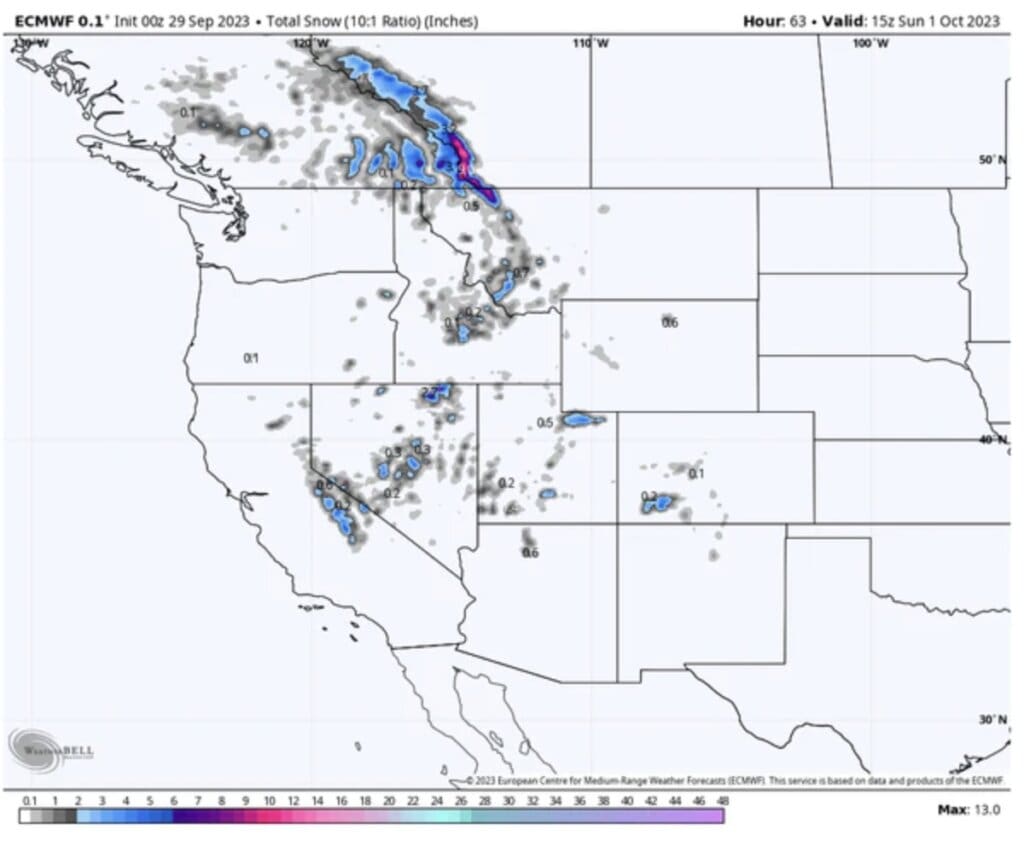
Below: Overall snowfall for the west highlighting Alberta Canada (Upper peaks), extreme northern Montana, Southern Sierra, Northern Utah, and perhaps the San Juan Range in Colorado. Moisture is fizzling as it reaches Colorado, however decent rain totals are noted in southern areas including Northern New Mexico. Temps are borderline for much snow aside from peaks near 10K (Light snow).
Extended:
In the extended outlook, a secondary low forms over southern Colorado and slowly moves north and east on Tuesday/Wednesday. It’s possible that the Front Range of Colorado including the core of the I-70 corridor grab some teasers, colder temps and light snow during this period
High pressure takes hold beyond Wednesday next week before a stronger low-pressure system enters the west around October 10th.
Below: Low pressure is returning to the west near the October 10/11 timeframe. This might be a decent moisture event.

Please support our forecasts with a donation here or join our Concierge program for custom chases, forecasts, and direct contact with our weather staff. That program is going to see a price increase this season so if you sign up now, you get the old rates.
Please welcome our newest silver sponsor Skis.Com – a family-run business now based in the northeast. For more than 50 years they have provided their customers with the best selection of skis, snowboards, clothing, and accessories which can be found at snowboards.com and skis.com.
You can follow my photography, and outdoor adventure on Instagram @powderchasersteve. Check out my latest collections of Alaska Brown Bears!
We will see you on the slopes soon!
Powderchaser Steve