

Quite an interesting approach to finding your way on the mountain created by Saalbach-Hinterglemm. The system treats on slope navigation more like a network highway than ski trails. The Austrian alpine resort town, southwest of Salzburg just published this user guide video and it seems on the surface that this could streamline getting from point A to point B without whipping out your trail map at every confluence. More skiing and less cartographic work…that’s just good policy:
Reinventing a slope guidance system from scratch for such a large and varied ski area as the SKICIRCUS Saalbach Hinterglemm Leogang Fieberbrunn is a mammoth task. But those who aspire to be exemplary in terms of orientation, safety and system uniformity must lead the way.

EVERYTHING FIGURED OUT: KEY ELEMENTS AND UPDATES
- 10 alphanumerical skiing zones – positioned clockwise around the ski area
- Colours and shapes – for difficulty levels, safety, attractions… accessible for all
- Pictograms – simple symbols for fast comprehension
- Signposts – warnings, turn-offs with panoramas, distant destinations and attractions
- Slope markings – with emergency phone numbers on the back
- Panorama boards – general overview at the valley stations, detailed view at the top
- Alphanumerical station names
- Detailed panorama boards – at the exits
- Portals at the lift entrances – with location, slope information and routes
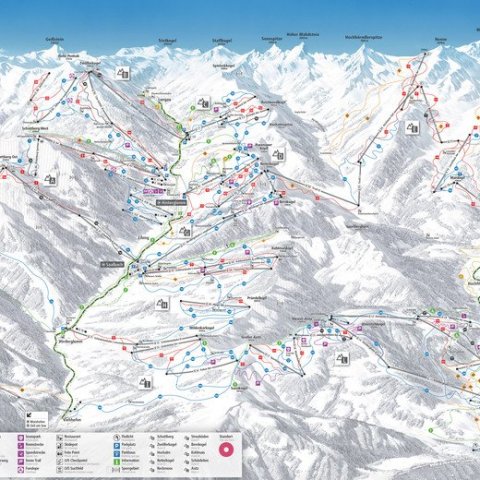
THE WHOLE SKICIRCUS IN 10 ZONES. ARRANGED CLOCKWISE. NOTHING TO IT.
10 alphanumerical zones and their mountain names reveal the big picture. Positioned in a clockwise manner around the main locations, they offer a clear, central orientation.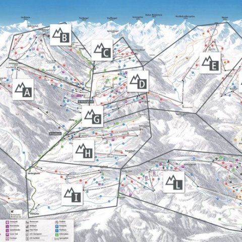
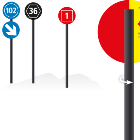
SIMPLE COLOUR-CODE SYSTEM. BASED ON SYMBOLS, ACCESSIBLE FOR ALL.
Six colours are all that are needed to convey all the relevant information on the go. The three difficulty levels have each been allocated a shape (circle, square, hexagon). This means that the difficulty level of a slope can be easily recognised, even with poor visibility or impaired colour perception. 4 shapes speak clearly, even without colour coding.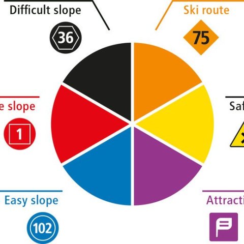
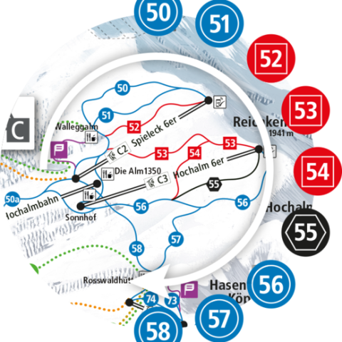
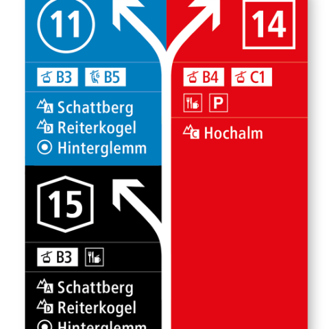
WHAT TYPE OF LIFT? WHICH ZONE? EVERYTHING MAKES SENSE WITH THE ALPHANUMERIC CODE.
Straightforward pictograms (lift type) and alphanumeric codes (zone/detailed zone) enable clear labelling of the lifts and ski area zones. The slopes are (like the zones) numbered in a clockwise manner and are therefore easy to distinguish on the panoramas and maps.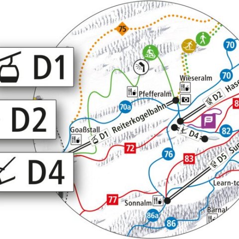
SYSTEMATIC SIGNPOSTS. ON THE GO, THE WAY IS CLEAR.
Just like a traffic control system, we highlight approaching turn-offs with warning signs. Turn-off signs are then positioned at the junctions. Both types of sign contain the relevant information for the turn-off.
All signposts indicate the difficulty level with their background colour.
In addition, panorama maps (general panoramas and detailed panoramas) are attached to many turn-off signposts to help with reorientation.
Along the slope: orientation, again and again.
The slope markings show that you are on the right track. And in case of emergency, emergency numbers are written on the back.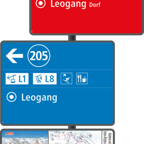
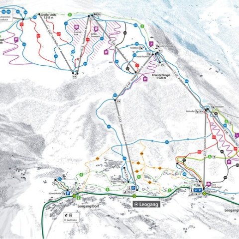
GENERAL AND DETAILED PANORAMAS. ALWAYS FIND OUT QUICKLY WHAT COUNTS.
At the valley stations there are large general panoramas and at the mountain stations there are zone panoramas. Guests can get a focused view of the slopes before them before embarking on their descent.
PANORAMA BOARDS. THE SOURCE OF ALL INFORMATION.
As well as the usual information, at numerous locations there is now an infrastructure module, which lists all highlights of the zone, including nearby huts.
If required, there is now also a safety module that shows the most important safety topics in an easily understandable way.
PORTALS AT LIFT ENTRANCES. IMPORTANT INFORMATION IN PASSING.
At the lift entrances there are grey portals with the key information for skiing fun: a one-stop information point with lift names, operating times, the time, safety information, skiing routes,…
ANALOGUE BEFORE DIGITAL. SIGNS BEFORE APPS.
The new slope guidance system is intended to offer safe and comprehensive orientation in the ski area. Therefore, the whole ski area has a motto: analogue before digital. Wherever our guests are in the ski area, we want them to be able to orientate themselves easily, quickly and in all conditions. And in case you do prefer digital orientation, the ALPIN CARD NAVIGATOR will soon be available. images from Saalbach-Hinterglemm