
Report From Powderchasers.com
OVERVIEW:
Models are in very good consensus with strong confidence of a double-digit event for New England focussing on northern Vermont and the Adirondacks of New York. Deepest amounts will come overnight Monday making Tuesday the perfect powder day. The west stays dry for the next week with the exception of moderate snow for central Montana and light freshies for the Front Range of Colorado Monday morning. The extended shows the ridge breaking down towards the 3rd week of November for the west.
EAST:
I would debate and early season chase for New England during the upcoming week with a strong polar airmass dropping into all of New England for the upcoming week. Record-setting cold temps late Monday night (15-20 degrees below normal) will bring snowfall to most ski areas of northern and central New England Monday/Tuesday. The bulk of the snow will fall late Monday afternoon through early Tuesday.
Below: Cold front is well entrenched over most of Vermont by Tuesday morning (-10C at 2400 feet). The coldest air and instability are likely going to be found over Vermont with all other areas getting colder as the front drops south over all of New England bringing very cold temps to all metro areas.

The Euro shows a narrow band of heavy snow (7-12 inches) over Northern Vermont with much less further south. The GFS pushes the snowfall further south so central Vermont and the Ski areas of central New Hampshire should also do well (4-8) if that model proves correct. Confidence for heavy snow is high for Bolton Valley, Stowe, Mad River Glen, Jay Peak, Smug, and others while areas further south towards Sugarbush will see slightly lower amounts. Southern Vermont is likely to only see light snow. With N-NW winds and cold air behind the front, late Monday night the northernmost mountains of Vermont will benefit from lake-effect as well as tip the scales upwards of 11-15 inches as the storm exits Tuesday morning (Isolated pockets).
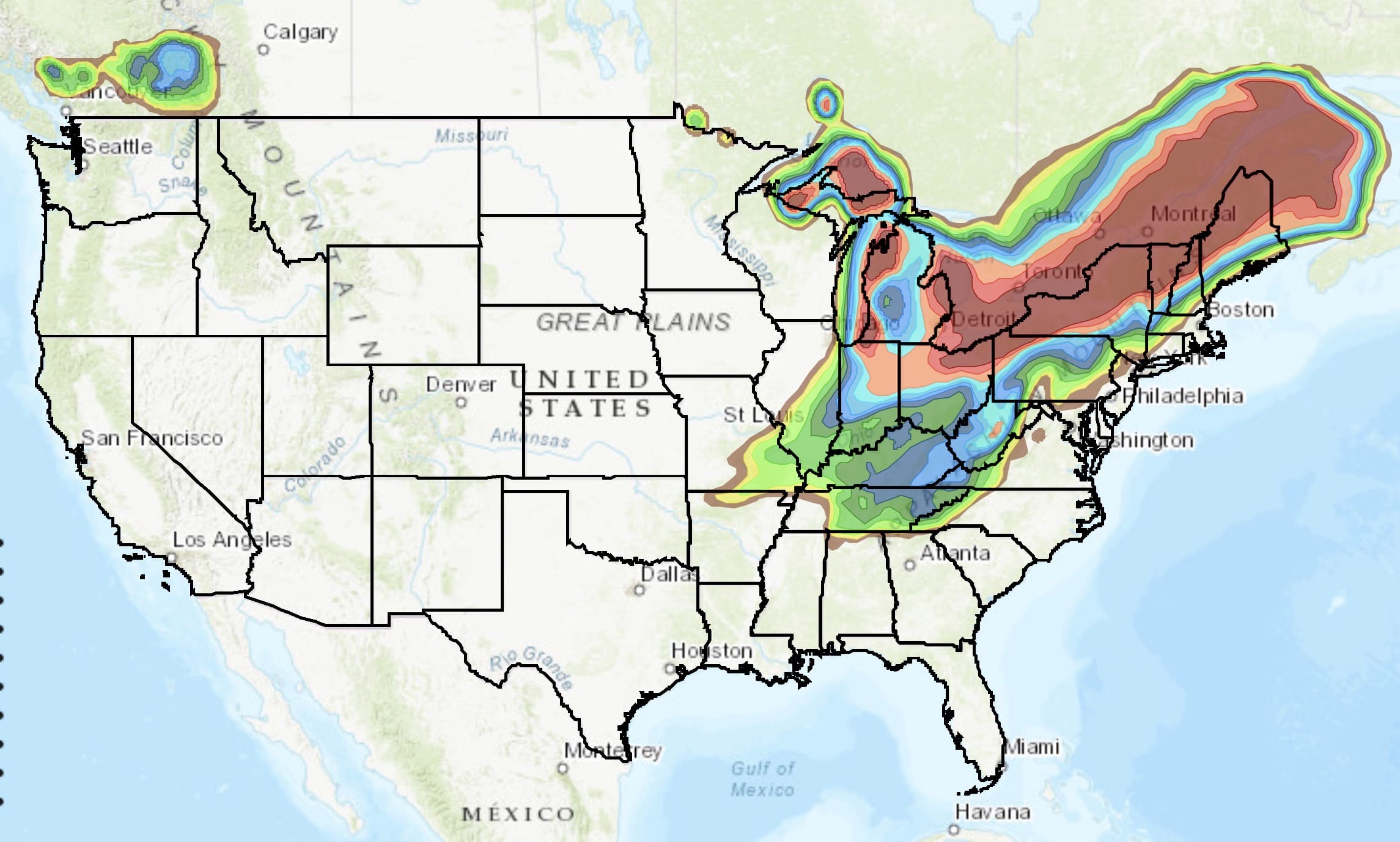
Below: GFS showing heavy snowfall for northern Vermont (8-12) and the Adirondacks of New York by early Tuesday morning. Moderate snow (3-7) is likely for central regions of Vermont and perhaps New Hampshire favoring Wildcat or perhaps Cannon on the north side of Conway. The Euro shows less snow to the south mainly focussing on the northern areas of Vermont.
 WEST:
WEST:
I mountain biked around Boulder Colorado yesterday where it was in the upper 70’s on Saturday. A brush by tease with much colder air is currently brewing in central Montana (Moderate snow). Northern Metro areas of Colorado near the Wyoming border may see 1-3 inches with less further south by Monday morning. Ski areas along the Divide near Denver may only grab flurries. The ski resorts in Montana including Bridger and Big Sky could see some accumulating light snow by late Sunday night (1-3).
The extended forecast shows the ridge breaking down slowly towards the 3rd week of November. Keep your snow dance going!
EXTENDED:
In the west high pressure, with a warming trend with the departing cold front in the eastern Rockies settles in for the remainder of this week (High confidence). The ensembles are in agreement that it’s likely the ridge retreats at some point around November 19/20th timeframe. It is likely this opens up the door for some systems for the west, but it’s too far out to make predictions on where or how much snow will be falling. Moderate confidence at this point that the ridge retreats, with low confidence on amounts or who will see snow.
Below: Long-range GFS ensembles show the ridge retreating over the west at some point around the 20th of November.

ANNOUNCEMENT:
We are excited to partner with @DrinkULLR to give away ten individual ULLR Nordic Libation prize packs throughout the season! Submit an original photo of ULLR Nordic Libation in the snow using the hashtag #ULLRPowderchase and Like @DrinkULLR for a chance to win some ULLR swag*. Visithttp://bit.ly/ULLRPowderChase for the official rules and more information. *Prize Pack includes an ULLR Sweatshirt, ULLR Pom Beanie, ULLR bumper Sticker, ULLR Richardson Hat and ULLR Flask. Contest begins 11/4 and ends 3/31/2020.
Anyone that signs up for the Concierge program below will receive a $75 off coupon that can be used to purchase a Mountain Collective Pass.