

Another winter storm is impacting the Sierra and by Thursday at noon, some of the higher elevation resorts could see upwards of 2+ FEET of new snow reports NOAA.
Right now the dual focus of this storm is set on the northern western and southern ends of Lake Tahoe along the Sierra Crest. Sugar Bowl, Squaw, Alpine Meadows, and Kirkwood should all come out of this storm rather snowy. Other resorts such as Heavenly, Mt Rose, and Boreal should also fare well– just not quite as deep.
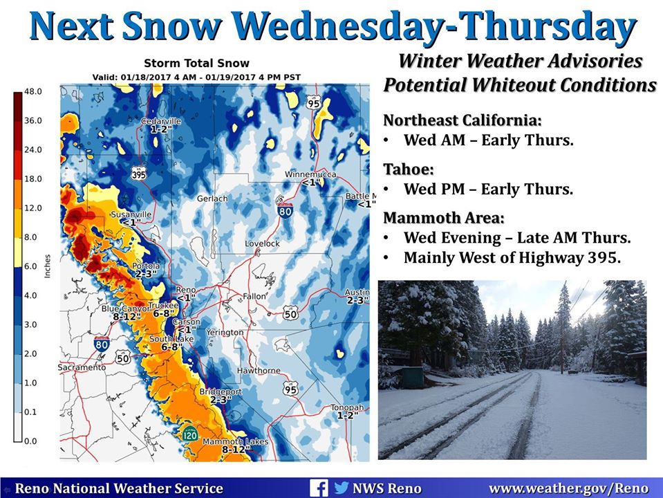
“The first in a series of storm systems will bring moderate snowfall amounts to the Sierra and northeast California Wednesday into Thursday morning.” – NWS Reno
In the meantime look for Friday to be one of the best storm days of the season at Squaw and Kirkwood as continued snow with low snow levels and will keep powder conditions on tap throughout the weekend.
LET IT SNOW!


Winter Storm Warning
…HEAVY MOUNTAIN SNOW POSSIBLE TODAY INTO THURSDAY…
.THE FIRST IN A SERIES OF WINTER STORMS WILL IMPACT NORTHERN CALIFORNIA TODAY INTO THURSDAY. SNOW LEVELS ARE FORECAST TO START OUT BETWEEN 5000 AND 6000 FEET THIS AFTERNOON THEN LOWER SLOWLY TO AROUND 4000 FEET BY MID DAY THURSDAY. 8 TO 15 INCHES OF SNOW ARE POSSIBLE ABOVE 4500 FEET, WITH OVER 2 FEET POSSIBLE ALONG THE HIGHER PEAKS. ADDITIONAL WINTER STORMS ARE LIKELY TO BRING HEAVY MOUNTAIN SNOW LATER THIS WEEK.
WESTERN PLUMAS COUNTY/LASSEN PARK- WEST SLOPE NORTHERN SIERRA NEVADA- INCLUDING THE CITIES OF CHESTER, QUINCY, AND BLUE CANYON | 4:39 AM PST WED JAN 18 2017
…WINTER STORM WARNING REMAINS IN EFFECT FROM 10 AM THIS MORNING TO NOON PST THURSDAY…
* MAIN IMPACTS: TRAVELERS MAY EXPERIENCE HAZARDOUS TRAVEL CONDITIONS AND LONG DELAYS. CHAIN RESTRICTIONS LIKELY. SNOW AND BLOWING SNOW MAY BRING PERIODS OF NEAR WHITE-OUT CONDITIONS.
* CONFIDENCE…HIGH.
* TIMING…MIDDAY WEDNESDAY THROUGH MIDDAY THURSDAY.
* LOCATIONS…LASSEN PARK…INTERSTATE 80 OVER DONNER PASS… HIGHWAY 50 OVER ECHO SUMMIT…HIGHWAY 88 OVER CARSON PASS.
* SNOW ACCUMULATIONS…8 TO 15 INCHES OF SNOW POSSIBLE ABOVE 4500 FEET, WITH OVER TWO FEET POSSIBLE ALONG THE HIGHER PEAKS.
* OTHER IMPACTS…STRONG WINDS WITH GUSTS UP TO 50 MPH POSSIBLE THIS EVENING.