
The short answer to that question is – very, very bad things. California is not just the raddest state in the US, it’s also a ticking seismic timebomb, situated on terra infirma that hosts the unholy combination of the worlds 8th largest economy, some of the highest-density population centers in the Western United States, and some of the highest large-earthquake recurrence rates on the planet.

The San Andreas fault is arguably the most famous fault in California. But one of it’s lesser-known cousins, the Hayward fault, is potentially much more deadly. The Hayward Fault runs right through Oakland and downtown Berkeley, where it splits Cal Stadium neatly in two, literally. The stadium was built right on top of the fault, and due to fault creep has been sheared apart by at least 13” – workers have had to bridge gaps in steel skeleton of the stadium with steel plates as the earth slowly tears the stadium apart. A large earthquake would almost certainly finish the job.
Some people might remember the Loma Prieta earthquake in 1989. That event was most certainly NOT the “big one.” It released only ~3% of the amount of energy released during the 1906 San Francisco M7.8 earthquake, and it occurred in the far-away Santa Cruz Mountains. The Hayward fault runs right below hundreds of thousands of people, thousands of miles of roads, and numerous bridges. There hasn’t been a large earthquake on the northern part of the Hayward in the last 300 years, and the recurrence interval on the adjacent part of it is roughly one event every 210 years (Parsons, 2008). Its overdue for a big earthquake.
According to the USGS (Working Group, 2008), there is a 63% chance of a magnitude 6.7 or greater earthquake happening in the Bay Area by the year 2036. What would happen if a magnitude 7 earthquake struck the Hayward Fault? First of all, California wouldn’t fall into the ocean. The major hazards that would result from a significant earthquake on the Hayward Fault include ground rupture and subsequent infrastructure damage, fires, dam failure in the Delta, toxic chemical spills, landslides, liquefaction, and tsunami.
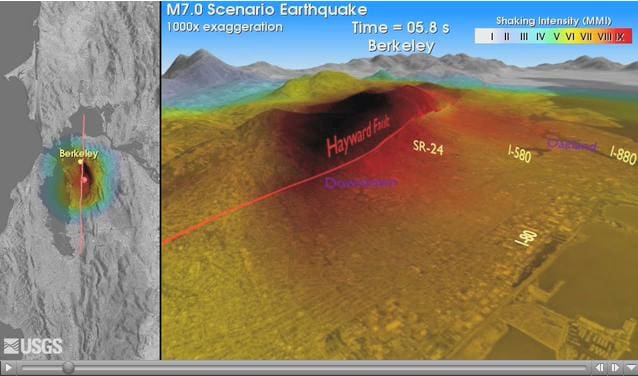
A magnitude 7 Hayward earthquake has the potential to displace and crack the ground as much as 3-4 feet, with ruptures occurring along all ~50 miles of the fault. Large areas of Oakland and Berkeley would experience ground shaking levels of IX on the Modified Mercali Scale (MMS) of earthquake intensity. This level is categorized by “heavy damage”, and “violent” ground shaking, along with “general panic.”
Video shows computer modelling by the USGS of a M7 earthquake on the entire Hayward fault, with an epicenter in Oakland. The shaking of the terrain is exaggerated 1000x to make it visible across the Oakland area in such a small video window. The darker red colors represent the areas that experience the IX-type shaking described above.
The things that man builds on the surface of the earth respond to shaking from earthquake waves with varying degrees of strength. Some things make it just fine, swaying and flexing, while others crack apart and crumble. Unreinforced masonry buildings perform particularly poorly, as do any buildings or infrastructure built on landfill or unconsolidated soils. These soils experience liquefaction, where water in them rises to the top and geysers of muddy water erupt from the ground during the earthquake. Large swaths of land across the Bay Area are reclaimed landfill, and buildings built on these areas would barely stand a chance.

According to risk modelling done by the Association of Bay Area Governments (ABAG), ~155,000 housing units would be uninhabitable for several months. Over 1,700 roads would be closed, including I-80, the old Bay Bridge, and the Golden Gate Bridge. These major arterial roads would suffer heavy damages, and would probably be out of service for at least a few months. BART would also be out of commission.
There could be from 6,000 to 10,000 water main breaks, hindering firefighters ability to put out any blazes that would result from natural gas pipe ruptures. If it was a windy, hot summer day, the fire problem would be much, much worse.
Levees in the Delta would be likely to rupture, allowing seawater to rush in and bury hundreds of square miles of ripe agricultural land. This could cause up to $20 billion dollars of damage there alone, not to mention disrupting drinking and farm water flow to Southern California for many months.
The ABAG estimates roughly $90 billion in economic exposure, and around 100-700 casualties. Estimates of deaths and injuries can be grossly inaccurate however, due to huge variations in potential exposure of people at different times of day, depending on whether they are at home, at work, or in transit between the two. Many more people would have been killed during the 1989 Loma Prieta earthquake if the World Series had not been taking place, moreover if the A’s hadn’t been playing the Giants.
In summary, a large earthquake on the Hayward fault is inevitable, and would have incredibly dire consequences for California and the economy of the United States. It is of paramount importance that we prepare for this probable and inevitable disaster by continuing to retrofit existing structures, and designing new buildings and infrastructure to withstand strong earthquakes.
More Information
Check this website out for more information about potential ground shaking where you live:
http://quake.abag.ca.gov/shaking/
What can you do to prepare for such an enormous natural disaster? this website has lots of great information:
http://www.earthquakecountry.info/roots/cover.html
One of the best things you can do is to prepare several earthquake kits, and keep one at home, one at work, and one in your car. These include water, medications, first aid kits, food, flashlights, batteries, maps, and a radio.
Next week, I’ll answer the question: “Why are the Eastern Sierra so much more badass than the Sierra around Tahoe?”
References
Parsons, 2008. Earthquake Probability calculated from paleoseismic observations on the south Hayward Fault, Proceedings of the Third Conference on Earthquake Hazards in the Eastern San Francisco Bay Area, October 22-24, 2008
USGS Working Group on Earthquake Probabilities. Forecasting California’s Earthquake- What Can We Expect in the Next 30 Years?– USGS Fact Sheet 2008-3027 at http://pubs.usgs.gov/fs/2008/3027/