

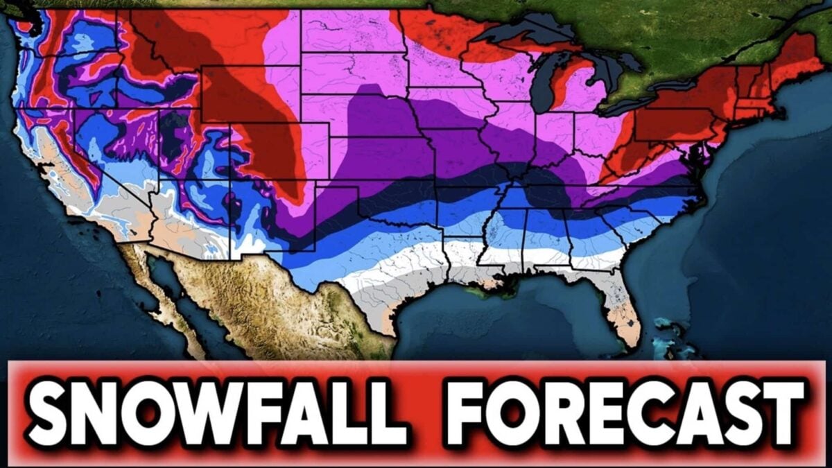
Direct Weather has released its snowfall outlook for the 2026-2027 winter, and it lands very differently to last season. The forecast compares expected snowfall against each region’s annual average, and the headline is a north-south split: a wetter, more active southern half of the country and a quieter northern tier.
The driver this winter is El Niño, and a strong one. NOAA now puts the odds of a very strong event through the heart of winter above 90%, and gives a 69% chance that the October to December period finishes at or above +2.5°C on the relative Niño index, which would put it ahead of every El Niño in the record back to 1950. In practice that means a loaded southern storm track, a wetter south and southeast, and a northern tier that gets its cold in sharp bursts rather than long settled freezes. More on the ENSO upgrade here.
Sierra Nevada: The Strongest Signal On The Map
The Sierra Nevada carries the highest confidence for above average snowfall anywhere in the forecast. Direct Weather expects above average precipitation across California, Nevada, Arizona and surrounding parts of the Southwest, and the highest Sierra terrain already averages more than 72 inches a year. An above average season on top of that baseline is a big number. The Farmers’ Almanac reaches the same place from a different direction, calling the Southwest the clearest winner of an El Niño winter, with repeated significant storms from December through March.
The caveat is elevation. A warm, wet pattern delivers rain low and snow high, so the valley floor and the lower lifts may not see the same benefit as the ridgelines.
Southern Rockies And The Southwest
Colorado and New Mexico sit in the favoured zone. The Almanac flags the southern Rockies as a region that could do especially well for mountain snowfall this winter, and NOAA’s September outlook agrees, favouring above normal precipitation across the southern Rockies and the Southwest. For anyone planning a trip, this is the part of the map with the most agreement between sources.
Pacific Northwest And Northern Rockies: The Quiet Half
Washington, Oregon, Idaho and western Montana look like the less active regions. Direct Weather expects warmer than average temperatures and below average precipitation across much of the area, which points to below average snowfall chances. High elevation resorts will still bank serious snow, since many of these mountains average well over 48 inches and some clear 72 inches, but the storm track is forecast to spend less time there. The Almanac makes the same call in different words, describing the Cascade snowpack as less dependable than usual.
Great Lakes, Appalachians And The East
Higher ground across Pennsylvania, New York, Vermont, New Hampshire, Maine and the wider Appalachian chain has an elevated chance of beating its seasonal average. The Almanac expects several rounds of heavy, wet snow inland during January and February, with coastal areas more likely to see rain and mixed precipitation as storms ride up the seaboard.
The Great Lakes are the one place the sources disagree. The Almanac expects lake effect bursts to keep hammering the snowbelts from Lake Michigan through Lake Ontario, with Cleveland, Buffalo, Erie and the Upper Peninsula the usual targets. NOAA’s September map, by contrast, shows a below normal precipitation signal across the Lakes. Both can be true: lake effect is a local machine that runs on cold air over open water, not on a seasonal precipitation anomaly.
Reading A Snowfall Map Properly
A snowfall chance forecast is not a total. It is the probability of finishing above or below a local average, and those averages vary enormously: a trace to three inches along the Gulf, 12 to 24 inches across much of the Mid-Atlantic and Ohio Valley, 36 to 48 inches through the Upper Midwest and interior Northeast, and 72 inches or more in the high Cascades, Sierra and Rockies. A below average year in the Sierra can still bury a below average year anywhere east of the Mississippi.
Timing is the other trap. Below normal temperatures and above normal precipitation only add up to snow if the two arrive together, which is exactly why the Northeast is the hardest region on this map to call.
The Short Version For Skiers
- Best odds: Sierra Nevada, southern Rockies, southern Utah and Arizona high country.
- Solid but storm-dependent: interior Northeast, higher Appalachians, Great Lakes snowbelts.
- Most uncertain: Pacific Northwest and northern Rockies, where warmth and a quieter track are both forecast.
- Wet but rarely white: Texas, the Gulf states and the Southeast, where El Niño moisture usually falls as rain, sleet or freezing rain.
The full NOAA winter outlook is here, and the Farmers’ Almanac 2026-2027 forecast is here.
