

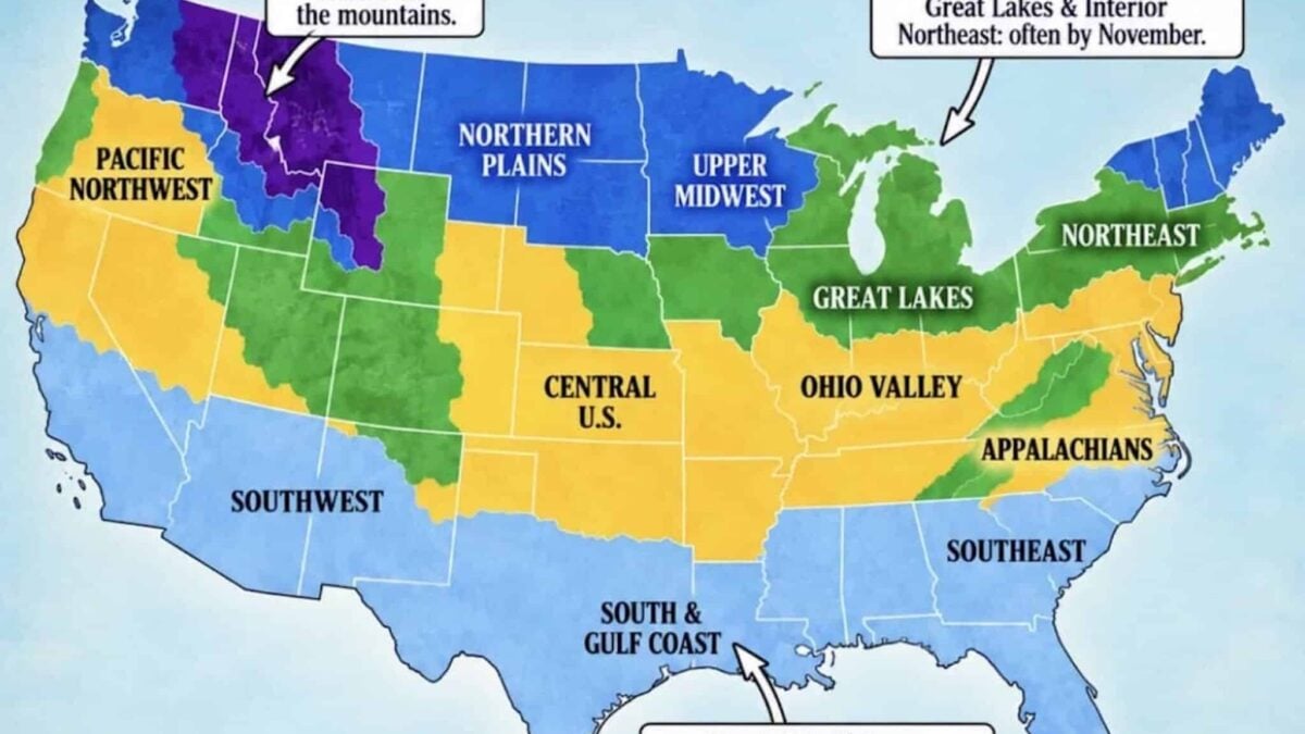
Skiers and snowboarders want to know one thing in September: when do the first flakes fly? The Farmers’ Almanac has published its first snowfall guide for the 2026-2027 season, and Direct Weather has layered its own temperature and storm-track outlook on top of it. Together they give a solid picture of when snow should reach your part of the country, and where this winter’s pattern is likely to nudge that earlier or later.
The driver this winter is El Niño, and a strong one. NOAA now puts the odds of a very strong event through the heart of winter above 90%, and gives a 69% chance that the October to December period finishes at or above +2.5°C on the relative Niño index, which would put it ahead of every El Niño in the record back to 1950. In practice that means a loaded southern storm track, a wetter south and southeast, and a northern tier that gets its cold in sharp bursts rather than long settled freezes. More on the ENSO upgrade here.
When The First Snow Usually Arrives
The Almanac splits the country into five broad windows. Treat these as climatology, the typical date, rather than a forecast for a particular storm.
- August and September: the highest elevations only. Peaks in the northern Rockies, the high Sierra and the Cascade volcanoes. Early dustings here rarely survive to become snowpack.
- October: the northern Rockies, northern Plains, Upper Midwest and northern New England. This is when higher ski areas start seeing snow that means something.
- November: the Great Lakes, central Rockies, interior Northeast and the higher Appalachians. The most common month for a first measurable snowfall in the country.
- Late November into December: the central Plains, Ohio Valley, Mid-Atlantic and the lower elevations of the Northwest.
- December, January or not at all: the Deep South, Gulf Coast, lower Southeast, Florida and the desert Southwest.
City averages worth knowing: Denver sees its first measurable snow around 18 October, the Twin Cities around 4 November and Buffalo around 8 November. Chicago usually picks up a trace by the end of October with measurable snow in November.
How This Winter’s Pattern Shifts The Odds
Direct Weather expects above normal temperatures across much of the Northwest and parts of the northern Rockies this autumn, which can push the first real snow back in Washington, Oregon, Idaho and western Montana even at elevation. The eastern half of the country leans the other way, with the Ohio Valley, Mid-Atlantic and Northeast carrying the highest confidence for colder than normal conditions, which raises the odds of an early first snowfall there.
The southern tier is the wildcard. An active El Niño storm track means more moisture across Texas, the Gulf states and the Southeast than those areas normally see. When a cold shot lines up with one of those systems, places that often wait until January can get their first flakes, or more likely their first sleet and freezing rain, earlier than usual.
What It Means For Ski Season
For early turns, the smart money is on the southern Rockies and the Sierra Nevada, both of which sit under the wetter half of this pattern, plus the interior Northeast once the cold arrives. The Pacific Northwest is the region to watch with the most caution: the terrain is there, but the storm track may not be, at least early on. Direct Weather’s full 2026-2027 snowfall forecast is here, and the Almanac’s first snowfall map is here.
Long-range guidance moves. Check it again when the first real system shows up on the medium-range models, and treat any single map as a probability rather than a promise.
