

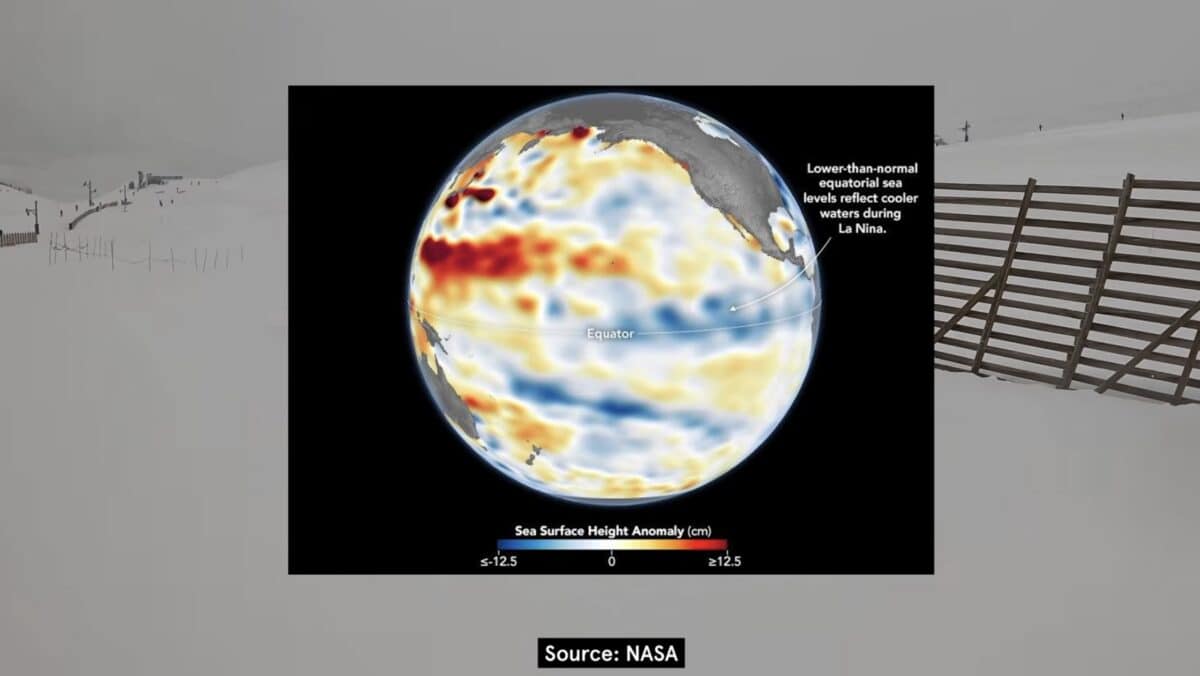
One of the strongest El Niño events in the modern times is developing ahead of the 2026-27 North American ski season, giving skiers plenty of reason to watch the winter forecast closely and PeakRankings is ready to address it head on.
NOAA’s Climate Prediction Center said Sept. 10 that El Niño is strengthening, with a greater than 90% chance of becoming a very strong event during the Northern Hemisphere fall and winter. NOAA currently gives the October through December period a 75% chance of producing a historic event that exceeds the strength of previous El Niño events in its record dating to 1950.
That is an unusually strong climate signal heading into ski season, but a detailed look at recent winters and previous powerful El Niño events shows why it should not be confused with a snowfall forecast.
PeakRankings did a deep dive on the potentially historic storm season examining six North American winters comparing what forecasters expected with what actually happened at ski areas across the continent.
What El Niño Actually Tells Skiers
El Niño develops when unusually warm water in the central and eastern tropical Pacific combines with changes in winds and tropical rainfall. Those changes can influence the jet stream and alter where storms tend to travel across North America.
During a typical El Niño winter, wetter conditions become more likely across portions of the southern United States, while the Pacific Northwest and parts of the northern tier often lean warmer or drier. For skiers, that can shift the seasonal odds toward California, the Southwest and portions of the southern Rockies while creating a less favorable large-scale signal farther north.
The important word is “odds.” NOAA specifically cautions that typical El Niño impacts are common patterns, not guarantees. The agency notes that El Niño can influence winter temperature and precipitation probabilities, but other atmospheric patterns still determine what happens during any particular storm or season.
The current seasonal outlook reflects that uncertainty. NOAA is using the unusually strong El Niño signal heavily in its latest long-range forecast, but it still describes temperature and precipitation in terms of probabilities rather than specific snowfall totals.
That distinction is especially important for ski areas. Above-average precipitation does not necessarily mean above-average snowfall if temperatures are too warm, and a favorable three-month precipitation outlook cannot tell skiers whether storms will arrive during the particular week they booked a trip.
Recent Winters Have Repeatedly Broken the Script
The 2022-23 season provides one of the clearest examples of why ENSO forecasts have limits.
That winter occurred during the third consecutive La Niña. Seasonal guidance generally favored the Pacific Northwest and northern Rockies while pointing toward drier conditions in California and the Southwest. Instead, California and Utah experienced extraordinary snowfall as repeated storms tracked much farther south than expected.
Mammoth Mountain finished with more than 700 inches of snow, while Utah experienced one of the snowiest winters in its history. PeakRanking’s analysis notes that 13 of Utah’s 15 major ski resorts broke snowfall records, while some areas farther north that were theoretically better positioned under La Niña had much more ordinary seasons.
The following winter showed a different limitation.
El Niño returned for 2023-24, and the broad forecast favored a more active southern storm track. That pattern eventually appeared, but not before an exceptionally poor start to winter. According to PeakRanking, snowfall across Western North America stood at just 57% of normal by the end of December.
Conditions changed dramatically after New Year’s. Storms increasingly favored the Sierra Nevada, Southwest, Utah and southern Colorado, eventually bringing the season much closer to the traditional El Niño pattern. Tahoe received a massive early March storm cycle, Utah finished well above average in many areas, and several southwestern ski regions benefited from the shift.
The seasonal forecast therefore looked reasonably good by spring. It would have been considerably less useful to someone who had booked a December ski vacation months earlier.
Last Winter Showed Why Temperature Matters So Much
The 2024-25 season followed the expected La Niña pattern more closely. The Pacific Northwest and northern Rockies generally performed well, the Southwest struggled, and much of Utah and Colorado landed closer to the middle. The PeakRankings describes it as one of the clearer examples in recent years of the large-scale ENSO signal translating into the expected regional snowfall pattern.
The following year the overall setup again leaned toward La Niña, but unusually warm temperatures became one of the defining characteristics of the North American ski season. Prolonged warmth across much of the West, rain reaching ski areas during major precipitation events and a damaging spring heat wave.
Those conditions eventually contributed to an unusually large wave of early ski resort closures across the Western U.S., including mountains in Colorado, California, Utah, Oregon, Washington, Idaho, Montana and New Mexico.
That season illustrates one of the biggest weaknesses in trying to translate a precipitation outlook directly into a ski forecast. A region can receive moisture and still struggle if temperatures repeatedly push snow levels above critical elevations.
Two Huge El Niño Winters Produced Very Different Results
Because the developing 2026 El Niño could become exceptionally strong, two historical seasons offer particularly interesting comparisons: 1997-98 and 2015-16.
The 1997-98 El Niño ranks among the strongest on record. South America received enormous snowfall during the preceding winter, and the pattern went on to produce an exceptionally wet winter across parts of the United States.
For Western ski areas, however, the results were not uniformly spectacular. California was among the clearest beneficiaries, while parts of Colorado and New Mexico did not perform nearly as well as a simple strong-El Niño forecast might suggest. At the same time, some supposedly less-favored northern areas experienced major storm cycles during portions of the season.
Another exceptionally strong El Niño developed ahead of the 2015-16 winter, but its impact on skiing looked very different.
The traditional forecast again favored wetter conditions across the southern U.S. and less favorable conditions in the Pacific Northwest and northern Rockies. Instead, several southern ski regions underperformed expectations while significant early-season snow reached parts of the northern West. The more typical warmer and drier northern pattern became apparent later in the season, but the winter as a whole did not neatly follow the forecast.
Those two winters are particularly relevant now because they demonstrate that El Niño strength alone does not determine where storms will go. NOAA makes the same point, noting that a stronger El Niño can increase the likelihood of certain impacts without guaranteeing their magnitude or location.
What the Current Outlook Means for Western Ski Areas
The developing 2026-27 pattern gives several regions reason to pay particularly close attention.
California and the Southwest are traditionally among the areas most likely to benefit when a strong El Niño pushes the Pacific storm track south. Southern Colorado and New Mexico can also find themselves in a favorable position if storms penetrate far enough inland.
Utah is more complicated. Recent analysis of what a powerful El Niño could mean for Utah skiing found that eight moderate-to-extreme El Niño winters produced an almost perfect split in the Cottonwood Canyons, with four finishing above average and four below average.
The Pacific Northwest generally sits on the less favorable side of an El Niño pattern, particularly because warmer temperatures can raise snow levels in the Cascades. That does not mean Washington and Oregon cannot have major powder cycles. It means the seasonal odds are less favorable than they would typically be during La Niña.
Much of Colorado also resists simple categorization. Southern Colorado can benefit from a southerly storm track, while northern and central portions of the state frequently sit closer to the edge of the strongest El Niño influence.
The Northeast is even harder to predict using El Niño alone. Precipitation can increase during portions of the winter, but temperature often determines whether that moisture becomes snow, mixed precipitation or rain.
South America’s Huge Winter Is Not a North American Forecast
PeakRanking also examines whether South America’s preceding ski season can provide clues about what comes next in North America.
There are some tempting comparisons. The exceptionally strong 1997 El Niño brought huge storms to the Andes before the powerful 1997-98 North American winter. The current pattern has similarly produced major snowfall in portions of South America during 2026.
History, however, does not show a consistent enough relationship to treat the Andes as a preview of North America’s winter.
PeakRanking found years in which South and North American ski seasons broadly followed their expected ENSO patterns, and others in which conditions diverged considerably between hemispheres. Changes in ENSO itself can also occur during the months separating the two ski seasons.
That means a snowy South American winter can be interesting evidence of the larger climate pattern, but it cannot tell skiers whether California, Utah, Colorado or Washington will have a huge winter several months later.
The Best Way to Read the 2026-27 Forecast
The developing El Niño is significant. NOAA now sees a greater than 90% chance of a very strong event and a 75% chance that it reaches a level exceeding previous events in the agency’s record during the October through December period. Those probabilities make the 2026-27 winter particularly interesting before the first meaningful snow has even fallen.
For skiers, however, the useful information is regional rather than specific. El Niño can help identify areas where the odds of certain temperature and precipitation patterns are increasing, but it cannot tell anyone in September whether Tahoe will get six feet during a January vacation or whether a Colorado storm will track 100 miles too far south.
That is ultimately the point reinforced by the winters examined by PeakRanking. Some seasons followed the ENSO playbook remarkably well. Others departed from it almost completely, and even winters that eventually matched their seasonal outlook often delivered that weather at very different times.
The 2026-27 winter has one of the strongest large-scale climate signals skiers have seen in years. It also remains a weather forecast, not a powder guarantee.
