

Winter Weather Forecast / Prediction / Outlook For Winter 2026 – 2027 Compared To Last Winter 2025 – 2026
From the looks of it, Winter 2026–2027 is shaping up very differently from last winter. The biggest reason is the rapid development of a very strong El Niño that can alter the position of the jet stream and shift storm tracks across North America.
NOAA declared an El Niño Advisory on July 9, 2026. Forecasters said El Niño was already strengthening and had a 97% chance of continuing into early spring 2027. NOAA also estimated an 81% chance that the event could become very strong during October through December, potentially placing it among the strongest El Niño episodes in the historical record, a dramatic change from winter 2025–2026, which was influenced by a relatively weak La Niña.
Last winter was exceptionally warm and dry across much of the western United States. The contiguous U.S. recorded its second-warmest meteorological winter on record, with an average temperature 4.9°F above the 20th-century average. It was also the nation’s fifth-driest winter in 131 years of records. The Northeast was the major exception, finishing cooler than average and experiencing a significant late-February blizzard. “The skiing in the Northeast was a solid one with a long cold stretch that kept the slopes skiing great for most of the winter,” says Tim Konrad, Founder of Unofficial Networks.
The Quick Outlook
Compared with last winter, the early 2026–2027 forecast favors:
- Warmer conditions across much of the northern U.S.
- A more active southern storm track
- Increased precipitation chances across portions of the southern U.S.
- Drier conditions becoming more likely in parts of the Pacific Northwest and northern tier
- More rain-versus-snow uncertainty along the East Coast
- Potentially productive storm cycles for the southern Rockies
- Greater reliance on elevation at western ski areas
This is a seasonal outlook, not a prediction of individual storms or resort snowfall totals. A warmer-than-normal winter can still include major cold outbreaks and blockbuster snowstorms.
How This Winter Weather Forecast Was Made
This comparison combines:
- NOAA Climate Prediction Center seasonal outlooks
- NOAA’s official El Niño forecast
- NOAA National Centers for Environmental Information winter observations
- Environment and Climate Change Canada seasonal forecasting resources
- Historical El Niño winter patterns
- The 1991–2020 climate-normal period
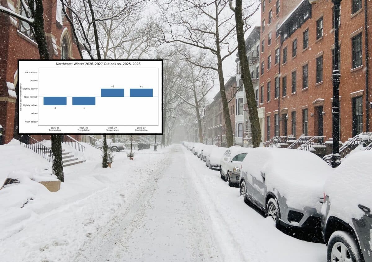
NOAA’s seasonal outlooks describe whether temperature and precipitation are more likely to finish above, near or below normal. They do not provide exact snowfall totals several months in advance. Official three-month forecasts are updated monthly as ocean temperatures, atmospheric circulation and computer models change. ts accompanying this article use a relative seasonal tendency index:
- +3: Much above normal
- +2: Above normal
- +1: Slightly above normal
- 0: Near normal or uncertain
- −1: Slightly below normal
- −2: Below normal
- −3: Much below normal
These values summarize the broad outlook and last winter’s observed pattern. They are not official NOAA probability values or predicted snowfall measurements.
Winter 2026–2027 vs. 2025–2026: Region-by-Region Comparison
1. Northeast
Includes Maine, New Hampshire, Vermont, eastern New York and western Massachusetts
2026–2027 Forecast
The Northeast enters winter with a mixed and highly storm-dependent outlook.
A strong El Niño often favors a more active subtropical jet stream and an increased number of coastal storms. However, El Niño winters can also be warmer overall, especially when storms track close to the coast or inland.
Interior and higher-elevation areas of northern New England may still see productive snowfall periods. Lower elevations will face more frequent questions about storm track, warm-air intrusion and rain-versus-snow lines.
The best opportunities may come when cold air is established before moisture arrives from the south.
2025–2026 Recap
Last winter was cooler than average in the Northeast, even as most of the country experienced exceptional warmth. A major February 22–24 storm brought blizzard conditions from the Mid-Atlantic into New England. NOAA estimated that more than 115 million people were affected by the snowfall, including approximately 28 million who received more than one foot. on was not consistently snowy, however. Much of the region also experienced below-average precipitation outside the major storm.
Key Difference
Winter 2026–2027 could be milder overall but potentially stormier, with more coastal-storm opportunities and greater rain-versus-snow uncertainty.
Tips for Skiers
- Favor higher-elevation destinations such as Jay Peak, Sugarloaf, Stowe and Killington.
- Keep travel plans flexible around storm tracks.
- Watch the rain-snow line closely for southern New England and the lower Hudson Valley.
- Northern Vermont, northern New Hampshire and western Maine may offer the best snow preservation.
2. Atlantic Corridor
Includes Boston, New York City, Philadelphia, Washington, D.C., and Richmond
2026–2027 Forecast
The Atlantic Corridor could see a busier winter storm pattern than last year, but snowfall will remain highly dependent on temperature.
A strong El Niño can supply abundant Pacific and Gulf moisture to storms moving across the southern and eastern United States. That can increase the opportunity for major East Coast systems. It does not guarantee snow in the major cities.
With temperatures favored to lean warmer across broad portions of the country, coastal areas may experience a mix of rain, wet snow and rapidly changing precipitation types.
Inland sections of Pennsylvania, New York and New England will generally have better odds of remaining on the snowy side of storms.
2025–2026 Recap
The eastern seaboard experienced colder conditions than much of the country, but the season was also dry overall. One major late-February storm dramatically improved snowfall totals in some locations, including record-setting snowfall in Providence, Rhode Island. Difference
The coming winter may offer more storm opportunities but warmer average conditions, creating a volatile mix of rain, snow, ice and coastal wind events.
Tips for Skiers
- Look inland and uphill when coastal forecasts turn marginal.
- Gore Mountain, Whiteface, Blue Mountain and central Pennsylvania resorts may benefit when storms track along the coast.
- Avoid booking nonrefundable trips solely on a seasonal snowfall prediction.
- Follow individual storm forecasts within seven to ten days of travel.

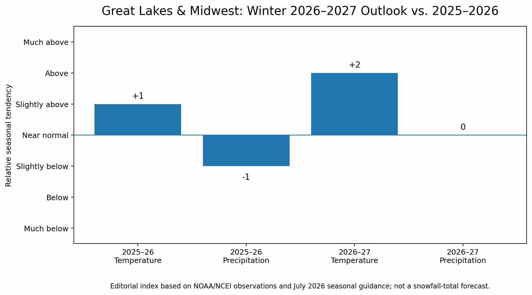
3. Great Lakes, Ohio Valley and Midwest
Includes Michigan, Wisconsin, Minnesota, Ohio, Indiana and surrounding areas
2026–2027 Forecast
The northern Midwest may experience a warmer winter than it did during many classic La Niña seasons.
Strong El Niño winters frequently shift the most persistent storm track southward. That can reduce the frequency of widespread northern-tier snowstorms, although individual systems and lake-effect events will remain possible.
Lake-effect snow will depend heavily on the timing of cold-air intrusions. Warmer open water can enhance snowfall when genuinely cold air arrives, but prolonged mild periods can produce rain, mixed precipitation and poor snow retention.
2025–2026 Recap
Last winter was warm across much of the Midwest and dry across large sections of the central and eastern United States. February precipitation was notably low from the central Plains through the Midwest and Ohio Valley.
Michigan’s Upper Peninsula was an important exception, recording much-above-average to locally record winter precipitation. Difference
Winter 2026–2027 may be warmer with less reliable large-scale snowfall, although lake-effect belts could still produce localized winners.
Tips for Skiers
- Prioritize lake-effect zones in Michigan’s Upper Peninsula and western Lower Peninsula.
- Look for resorts with strong snowmaking systems.
- Book around short-term cold outbreaks instead of assuming continuous midwinter coverage.
- Be prepared for rapid freeze-thaw cycles in the Ohio Valley.

4. Southeast and Deep South
Includes Florida, Georgia, Alabama, Mississippi, Louisiana and the southern Appalachians
2026–2027 Forecast
The Southeast may experience one of the clearest changes from last winter.
El Niño commonly strengthens the southern branch of the jet stream, raising the odds of wetter and more active weather from the Gulf Coast into the Southeast.
Most of that precipitation will fall as rain at low elevations. However, an active storm track can occasionally produce snow or ice when cold air reaches the southern Appalachians at the right time.
Western North Carolina, eastern Tennessee, West Virginia and Virginia could benefit from increased storm frequency, although warm-air intrusion will remain a concern.
2025–2026 Recap
Last winter was exceptionally warm across much of the South and Southeast. The winter was also dry, with drought expanding across a large portion of the country by early March. Mississippi recorded its driest February on record, receiving less than 30% of its normal February precipitation. Difference
The 2026–2027 season is expected to be wetter and stormier, though not necessarily colder.
Tips for Skiers
- Watch Appalachian resorts closely during brief cold windows.
- Snowmaking temperatures may be inconsistent at lower elevations.
- West Virginia and the highest terrain of North Carolina could outperform surrounding areas.
- Expect rain events between potential snow windows.


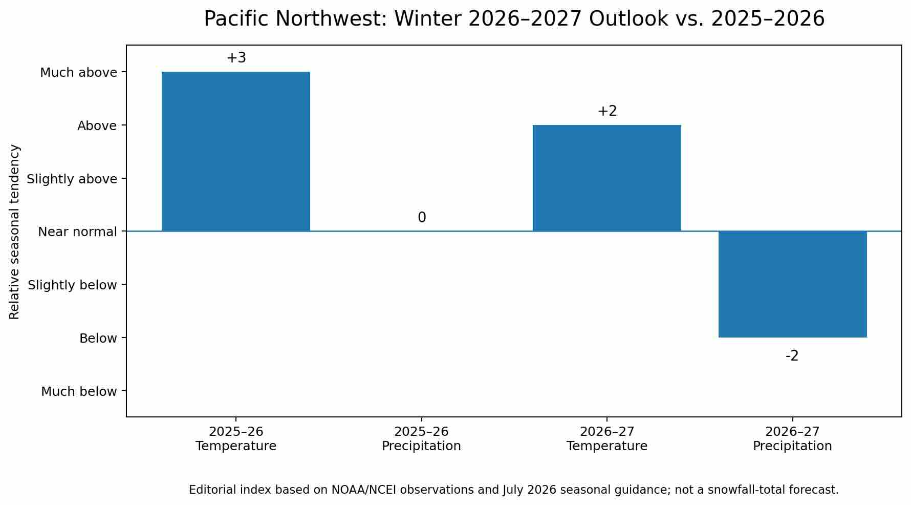
5. Pacific Northwest
Includes Washington, Oregon and coastal British Columbia
2026–2027 Forecast
The Pacific Northwest faces one of the more concerning early outlooks for skiers.
Strong El Niño winters frequently direct the most active Pacific storm track toward California and the southern United States, leaving portions of Washington, Oregon and British Columbia warmer or drier than normal.
Higher elevations can still receive substantial snowfall, especially during individual atmospheric-river or cold-frontal events. The greater concern is snow level. Warmer storms can produce rain at elevations that would ordinarily receive snow.
Washington’s northern Cascades may fare better than Oregon and the southern Cascades, but confidence in exact snowfall distribution remains low this far in advance.
2025–2026 Recap
The broader western United States experienced record or near-record winter warmth. NOAA reported that the West and Southwest each recorded their warmest winter on record. Early-season snowfall was below average across many parts of the Cascades and Rockies, although some northern Cascade areas performed better. Difference
Winter 2026–2027 may be drier overall with higher snow levels, increasing the importance of elevation and storm timing.
Tips for Skiers
- Favor higher-elevation terrain at Whistler Blackcomb, Mount Baker, Crystal Mountain and Timberline.
- Be cautious about early-season bookings.
- Watch freezing levels before atmospheric-river events.
- Northern Washington and interior British Columbia may offer better odds than lower-elevation Oregon destinations.
6. Canada
Includes British Columbia, Alberta, Ontario and Quebec
2026–2027 Forecast
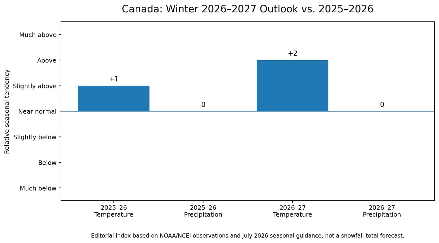
Canada’s outlook is more complicated than a single nationwide forecast can capture.
El Niño generally raises the odds of milder winter conditions across large portions of Canada, particularly western and central regions. Coastal British Columbia may see elevated snow levels, while the Canadian Rockies could experience longer dry spells between storms.
Ontario and Quebec may also trend milder, but an active southern and eastern storm track could still produce significant snow when cold air is available.
Eastern Canada may see a greater mixture of snow, ice and rain than during a consistently cold winter.
Environment and Climate Change Canada updates its probabilistic seasonal forecasts monthly through the Canadian Seasonal to Inter-annual Prediction System. Those forecasts cover temperature, precipitation and snow-water-equivalent trends for periods extending up to a year. –2026 Recap
Canada’s official winter outlook was influenced by a relatively weak La Niña. It favored warmer-than-normal conditions around Hudson Bay and parts of northern Manitoba, Ontario and Quebec, with more precipitation near the Rockies and a more active pattern in eastern Canada. onditions varied considerably by province and elevation.
Key Difference
Winter 2026–2027 may be milder across much of Canada, with southern and eastern storm tracks determining where precipitation falls as snow rather than rain.
Tips for Skiers
- Elevation will be critical in British Columbia and Alberta.
- Banff, Lake Louise and higher interior British Columbia resorts may preserve snow better during mild periods.
- Quebec and eastern Ontario could benefit from coastal or inland storm systems when sufficient cold air is present.
- Avoid treating one national outlook as a resort-specific snowfall forecast.
Why Winter 2026–2027 Could Be So Different
El Niño Is Replacing La Niña
The tropical Pacific has undergone a major shift.
NOAA reported that the Niño 3.4 region had warmed to approximately 1.2°C above normal by early July. Ocean and atmospheric conditions were showing clear signs of a coupled and strengthening El Niño. uly probability table gave El Niño a 100% forecast probability through the December–January–February period, followed by 99% for January–March and 97% for February–April. cal strong El Niño pattern includes:
- A stronger southern jet stream
- Increased storm activity across portions of California and the southern U.S.
- Wetter conditions near the Gulf Coast and Southeast
- Milder conditions across portions of the northern U.S. and Canada
- Reduced precipitation in parts of the Pacific Northwest
- Increased coastal-storm potential in the East, depending on available cold air
These are tendencies, not guarantees.
NOAA specifically warns that even very strong El Niño events do not produce the textbook pattern in every region. Atmospheric blocking, the polar vortex, the Arctic Oscillation, the North Atlantic Oscillation and short-term Pacific patterns can still overwhelm the seasonal signal for weeks at a time. his Could Mean for Ski Country
Potential Winners
Southern Rockies
A stronger southern storm track could benefit portions of New Mexico, Arizona, southern Colorado and southern Utah.
High-Elevation California
California ski areas can perform well during active El Niño winters, particularly if storms arrive with sufficiently low snow levels.
Interior Northeast
A more active East Coast storm pattern could produce significant snow inland, especially across elevated terrain.
Southern Appalachians During Cold Windows
More available moisture creates opportunities when cold air reaches the region at the right time.
Areas Facing Greater Risk
Pacific Northwest
Warmer temperatures, elevated freezing levels and longer dry periods are meaningful concerns.
Northern Rockies
El Niño can shift the storm track away from Montana, Idaho and northern Wyoming.
Upper Midwest
A mild northern-tier pattern could limit persistent natural snow outside favored lake-effect zones.
Lower-Elevation Coastal Resorts
More winter precipitation does not automatically mean more snow. Marginal temperatures can turn an active winter into a rainy one.
How Accurate Are Long-Range Winter Forecasts?
Seasonal forecasts are most useful for identifying broad climate tendencies.
They cannot reliably predict:
- Exact snowfall totals at individual resorts
- Specific storm dates months in advance
- Powder days
- Holiday-week conditions
- The precise elevation of the rain-snow line
- Short-lived polar-vortex disruptions
NOAA’s outlook maps show probabilities for broad three-month temperature and precipitation categories. They should not be interpreted as deterministic forecasts.
For trip planning, begin using seven-to-14-day weather forecasts as the date approaches. Snow forecasts become substantially more useful inside approximately five to seven days.
Preparing for Winter 2026–2027
Northeast
Target elevation and keep plans flexible. The region could see major storms, but rain-snow lines may be difficult.
Atlantic Corridor
Expect an active mix of rain, snow and ice rather than a consistently snowy urban winter.
Great Lakes and Midwest
Focus on lake-effect zones and resorts with strong snowmaking.
Southeast
A wetter pattern is likely, but meaningful natural snow will require well-timed cold air.
Pacific Northwest
Elevation and freezing levels will be among the most important variables of the season.
Canada
Milder national tendencies do not eliminate major snowstorms. Resort-level outcomes will differ sharply by province and elevation.
Bottom Line
Winter 2026–2027 is unlikely to resemble last winter.
Winter 2025–2026 was the second-warmest and fifth-driest meteorological winter on record across the contiguous United States, although the Northeast experienced colder conditions and a major late-season blizzard. ng season will be influenced by a strengthening El Niño that NOAA believes could become very strong by late 2026. That favors a more active southern storm track, warmer conditions across much of the northern tier and increased precipitation chances across parts of the South.
For skiers and snowboarders, the early outlook is encouraging for portions of California, the southern Rockies and potentially the interior Northeast. It is more concerning for the Pacific Northwest, northern Rockies and lower-elevation destinations vulnerable to rain.
As always, the best ski seasons are determined not only by how much precipitation falls, but by where the storm track sets up, how cold the air is and whether storms arrive at the right time.
This forecast will become more reliable as NOAA releases updated guidance during late summer and fall.