

.jpg)
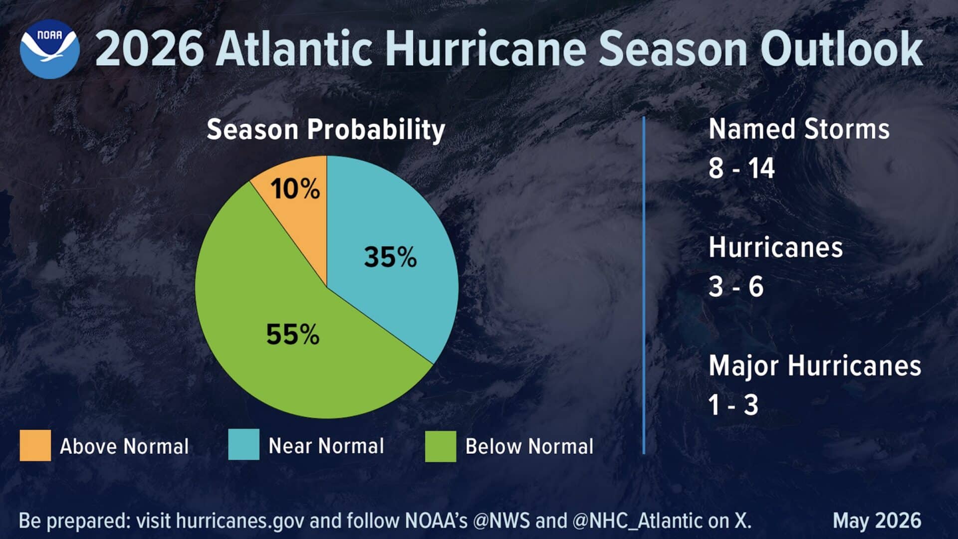
Federal forecasters are calling for a quieter-than-average Atlantic hurricane season this year, with NOAA putting a 55% chance on a below-normal season running from June 1st through November 30th.
The agency expects between 8 and 14 named storms to form, with 3 to 6 reaching hurricane strength and 1 to 3 becoming major hurricanes of Category 3 or higher. For context, an average season produces 14 named storms, seven hurricanes, and three major hurricanes.
Two competing forces are shaping the forecast. El Niño is expected to develop and intensify over the course of the season, which historically suppresses tropical storm activity in the Atlantic. On the other side of the ledger, Atlantic ocean temperatures are running slightly above normal and trade winds are weaker than average, both of which tend to fuel storm development. NOAA forecasters believe the El Niño effect will win out, tipping the overall outlook toward a quieter season.
“Although El Niño’s impact in the Atlantic Basin can often suppress hurricane development, there is still uncertainty in how each season will unfold. That is why it’s essential to review your hurricane preparedness plan now. It only takes one storm to make for a very bad season.” – National Weather Service Director Ken Graham
On the technology front, NOAA is rolling out several upgrades for the 2026 season. For the first time, data collected from small uncrewed aircraft will feed directly into the agency’s hurricane forecast model, a change scientists say can improve intensity forecast accuracy by 10%. Machine learning is also being applied to data from radar systems mounted on NOAA’s Hurricane Hunter aircraft, pulling in more than 25% more meteorological data than previous methods allowed.
The National Hurricane Center is also updating its forecast cone graphic to include tropical storm and hurricane watches and warnings for inland areas, and will begin testing an experimental version of the cone designed to capture a wider range of possible storm tracks.
NOAA’s flood mapping services, which provide emergency managers with street-level inundation visualizations, currently cover 60% of the U.S. population and are on track to reach nearly full national coverage by late September. The agency will update its 2026 Atlantic outlook in early August ahead of the season’s historically most active stretch, which typically runs from mid-September through October.