

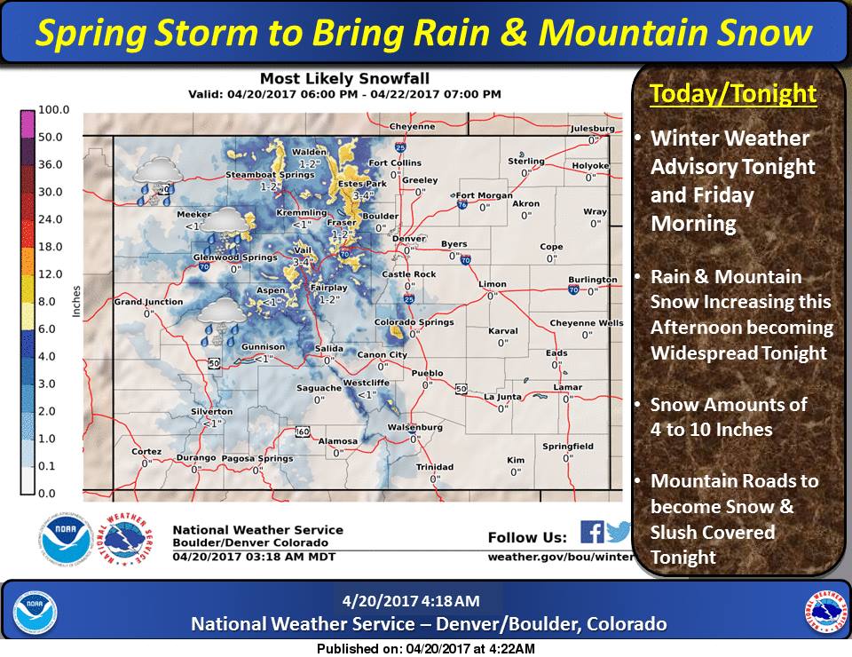
A winter weather advisory is currently in effect for most of Colorado’s front range with the heaviest snowfall happening near Estes Park and the higher elevations of Rocky Mountain National Park.
Look for Loveland, Winter Park, and Arapahoe Basin to pull down significant snowfall totals on their upper elevations by Friday morning. Mother nature couldn’t have planned better seeing as Winter Park closes this weekend!
“Snow showers will increase this afternoon and become widespread this evening. A few thunderstorms may form as well. Snow will decrease Friday morning” – NWS Boulder
The central mountains including Vail should also see accumulation, albeit lighter than their more eastern neighbors. For Colorado ski mountaineers, the new snow is a godsend and should give the 13’ers and 14’ers a much needed refresh heading into the weekend.
LET IT SNOW!
Forecast for Longs Peak | Rocky Mountain National Park


Winter Weather Advisory
A Pacific storm system will spread moisture and lift across Colorado today and tonight. Rain and mountain snow showers are expected to form this afternoon along with a few weak thunderstorms. Mountain snow is expected to become widespread this evening and then decrease Friday morning. Temperatures will be mild today ahead of the storm system resulting in snow levels above 10000 feet. Snow level will fall to the valley floor tonight and down to 7000 feet in the foothills Friday morning. Roads are expected to become snow cover and slushy in parts of the mountains tonight and Friday morning. If traveling tonight or Friday morning, allow extra time to reach your destination or wait until road conditions improve late Friday morning. Additional snow showers are expected to reform Friday afternoon and could produce a few slick spots.
…WINTER WEATHER ADVISORY IN EFFECT FROM 6 PM THIS EVENING TO 9 AM MDT FRIDAY…
The National Weather Service in Denver has issued a Winter Weather Advisory for Snow, which is in effect from 6 PM this evening to 9 AM MDT Friday.
* TIMING…Snow will become widespread this evening and then decrease Friday morning.
* SNOW ACCUMULATIONS…4 to 10 inches.
* WIND/VISIBILITY…Heavy snow may cause visibility to fall to a quarter mile for a short time. Over the mountain passes, westerly wind gusts to 30 mph may produce blowing snow and drop visibility to a quarter mile at times.
* IMPACTS…Snow and slush covered roads will likely create hazardous travel tonight and Friday morning.