

US National Weather Service Reno Nevada share with us some interesting information on the importance of Atmospheric River (AR) events on the health of a ski season.
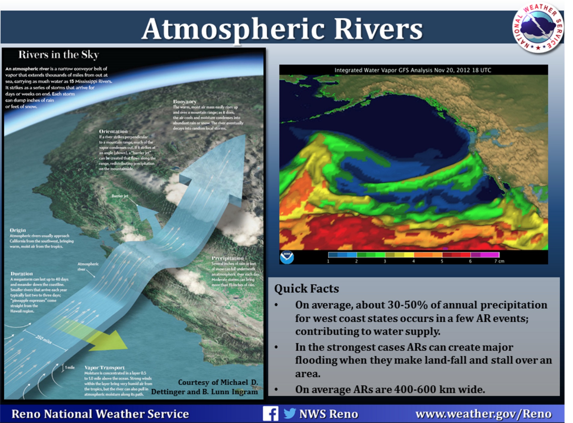
“On average, about 30-50% of annual precipitation in the west coast states occurs in just a few Atmospheric River (AR) events, thus contributing to water supply. In the strongest cases ARs can create major flooding when they make land-fall and stall over an area. ARs are a primary feature in the entire global water cycle, and are tied closely to both water supply and flood risks, particularly in the Western U.S. Improved understanding of ARs and their importance has come from roughly a decade of scientific studies using new satellite, radar, aircraft and other observations and major numerical weather model improvements.

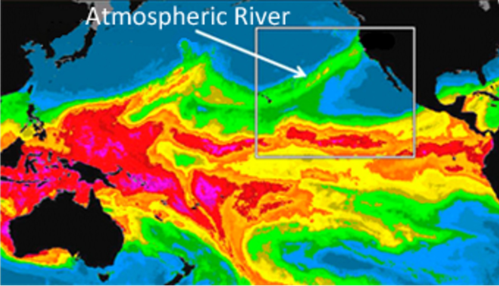
ARs are the water-vapor rich part of the broader warm conveyor belt (e.g., Browning, 1990; Carlson, 1991), that is found in extratropical cyclones (“storms”). They result from the action of winds associated with the storm drawing together moisture into a narrow region just ahead of the cold front where low-level winds can sometimes exceed hurricane strength. The term atmospheric river was coined in a seminal scientific paper published in 1998 by researchers Zhu and Newell at MIT (Zhu and Newell 1998). Because they found that most of the water vapor was transported in relatively narrow regions of the atmosphere (90% of the transport occurred typically in 4-5 long, narrow regions roughly 400 km wide), the term atmospheric river was used.
As of late 2010 there have been a number of papers published on major west coast storms where the presence and importance of AR conditions have been documented. These are provided in an informal list of the “Top Ten ARs” of the last several years on the U.S. West Coast. It is now recognized that the well-known “Pineapple express,” storms (a term that has been used on the U.S. West Coast for many years) correspond to a subset of ARs.
Can we forecast atmospheric rivers?
National Weather Service forecasters located along the west coast are now familiar with the concept of atmospheric rivers and can identify these phenomena in current numerical forecast models. This provides them the capability to give advanced warning of potential heavy rain sometime 5 to 7 days in advance. They have also learned to monitor polar orbiter microwave satellite imagery that provides advanced warning of the presence and movement of these phenomena in the Pacific. During the last two winters, with the development of atmospheric river observatories, forecasters have been able to monitor the strength and location of these rivers as they make landfall and thus improve short-term rainfall forecasts for flash flooding. There are still challenges to predicting rainfall totals in these events as models still struggle with the details of the duration and timing of AR’s as they make landfall.
Why are ARs capable of producing extreme snowfall on the U.S. West Coast?
AR conditions are conducive to creating heavy orographic precipitation (Ralph et al., 2005; MWR) because:
- they are rich in water vapor,
- they are associated with strong winds that force the water vapor up mountain sides,
- the atmospheric conditions do not inhibit upward motions (because the atmospheric static stability is nearly neutral up to about 3 km MSL, on average)
- once the air moves upward, the water vapor condenses and can form precipitation.
You can read more @ esrl.noaa.gov/psd/atmrivers/questions/