
The National Oceanic and Atmospheric Administration‘s (NOAA) Climate Prediction Center issued its summer 2026 seasonal outlook, offering probabilistic forecasts for temperature and precipitation across the country for July, August, and September.
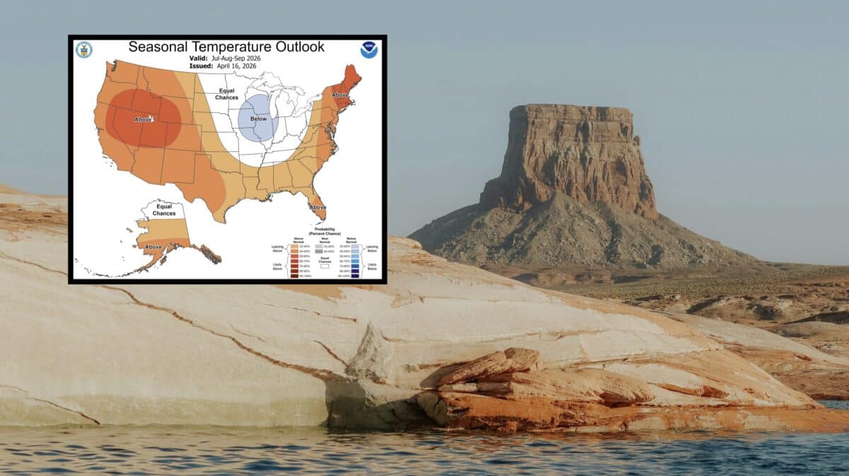
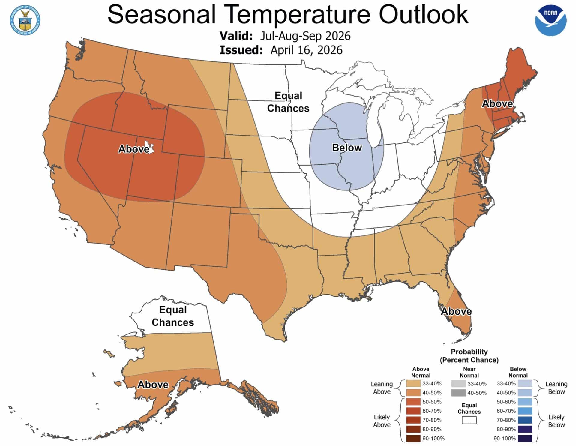
Summer Temperature Outlook
The temperature forecast for summer 2026 paints a very warm picture across the western half of the country, with the most intense signal sitting over the interior West. The core of that heat is centered over Utah, Colorado, Nevada, and surrounding states, where some areas show a 50-60% probability of above-normal temperatures. The warmth radiates outward from that bullseye across the entire West Coast, the Southwest, and much of the Plains.
The Northeast also leans above normal, with New England and the mid-Atlantic showing elevated odds of a hotter than average summer. The one notable exception on the map is a cool pool centered over the Upper Midwest and Great Lakes region, where parts of Iowa, Wisconsin, Minnesota, Illinois, and Missouri show a 33-40% chance of below-normal temperatures. That below-normal signal is the strongest cold signal on the map for the contiguous U.S.
Much of the Central Plains falls into equal chances territory, meaning no strong lean toward a warmer or cooler than normal summer. Alaska shows above-normal temperature odds across much of the state, with northern areas falling into the equal chances zone.
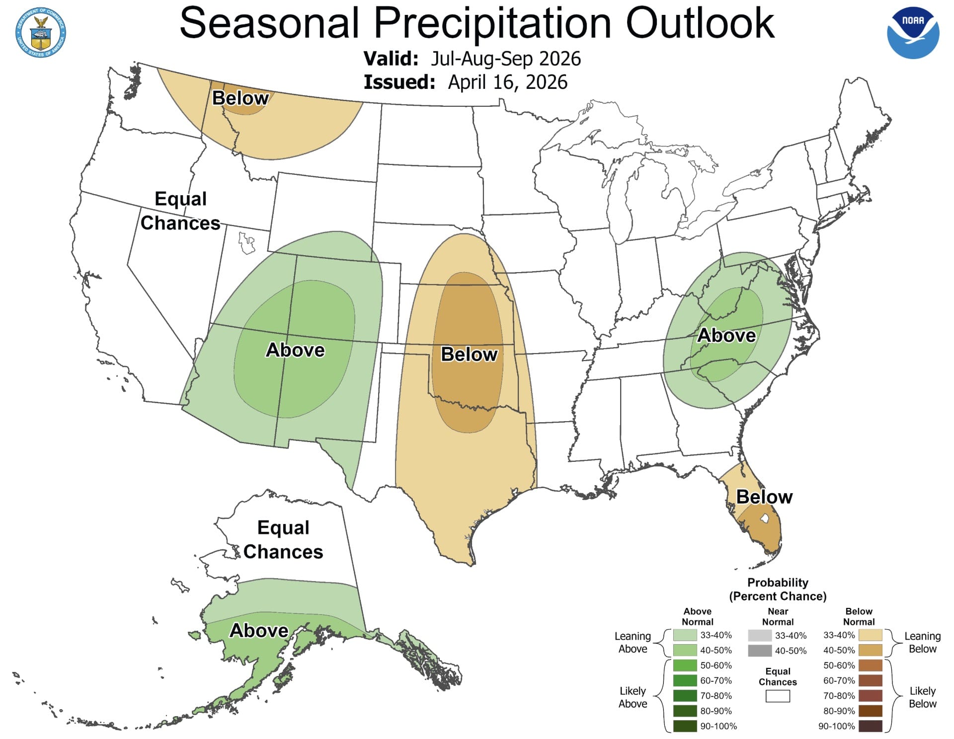
Summer Precipitation Outlook
The precipitation picture for summer 2026 is notably varied by region. The biggest wet signal on the map is centered over the Desert Southwest and the Four Corners area, where Arizona, New Mexico, Utah, and Colorado show above-normal precipitation chances in the 33-40% range and some areas in the 40-50% range. That signal is good news for a region that often deals with intense summer drought heading into fall.
The mid-Atlantic and Southeast show another notable wet zone, with Virginia, the Carolinas, and neighboring states leaning above normal for summer rainfall. That above-normal precipitation area extends from the Appalachians toward the coast.
On the dry side, the Pacific Northwest shows a below-normal signal centered over northeast Washington, northern Idaho, and much of Montana, with probabilities in the 33-40% range leaning below. A broad below-normal signal also covers the central Mississippi Valley corridor from Missouri down through Oklahoma and into Texas, with the core of that dry area showing 40-50% odds of below-normal precipitation.
Florida shows a leaning-below signal, which is notable given how much the Sunshine State typically relies on summer rainfall. Most of the northern and central Plains fall into equal chances territory on precipitation, as does northern Alaska.
Key Takeaways
NOAA’s summer outlook points to a hotter than normal season across most of the West and Northeast, with the greatest confidence of heat centered over the Rockies and Intermountain West. That same general region is one of the few areas with a meaningful above-normal precipitation signal, thanks to the summer monsoon pattern across the Southwest. The central U.S. faces a combination of near-normal temperatures and drier than normal conditions, which could have implications for drought development heading into fall.