

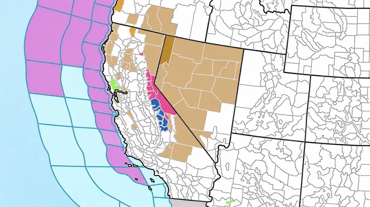
The National Weather Service has issued winter storm warnings across California’s Sierra Nevada as a powerful storm system approaches, bringing the potential for up to 2 feet of snow at higher elevations and wind gusts reaching 90 mph along some mountain ridges.
The warnings cover portions of the Sierra Nevada, Lake Tahoe region, Mono County and southern Cascades. The heaviest snowfall is expected Friday afternoon through early Saturday morning, with several major California ski resorts positioned to receive significant early-season snow.
Up to 2 Feet of Snow Expected in the Sierra Nevada
According to the National Weather Service in Sacramento, a winter storm warning will be in effect from 10 a.m. Friday, November 13, through 10 a.m. Saturday, November 14. The warning covers the northern Sierra Nevada above 6,000 feet, including areas around Donner Pass, Carson Pass and Lassen Volcanic National Park.
Forecasters expect up to a foot of snow at higher elevations, with totals potentially reaching 2 feet on the highest peaks. Snowfall amounts will decrease significantly at lower elevations, with only minor accumulations of up to 2 inches possible around 5,000 feet. Winds could gust as high as 60 mph.
Farther east, the National Weather Service in Reno has issued warnings for the Lake Tahoe region and Mono County. Around Lake Tahoe, snowfall could approach 12 inches above 7,000 feet, with up to 20 inches possible along the Sierra crest west of the lake. Ridge winds could reach 70 to 90 mph.
Mono County, home to Mammoth Lakes, is also in line for substantial snowfall. Forecasters expect 1 to 2 feet above 7,000 feet, with up to 6 inches between 6,000 and 7,000 feet. Little or no accumulation is expected below 6,000 feet.
Which California Ski Resorts Could Get Snow?
The approaching storm could bring a substantial dose of early-season snow to numerous Sierra Nevada ski resorts, particularly those with significant terrain above 7,000 feet.
In the Lake Tahoe region, Palisades Tahoe, Sugar Bowl, Boreal Mountain Resort, Northstar California, Heavenly, Sierra-at-Tahoe and Kirkwood are all positioned to receive snowfall from the incoming system. Resorts with higher-elevation terrain along and near the Sierra crest could see some of the more significant accumulations, while lower base areas may receive considerably less snow.
Farther south, Bear Valley and Dodge Ridge are also within the northern and central Sierra regions covered by the winter storm warnings. Both mountains could benefit from the incoming precipitation, although snowfall amounts will depend heavily on elevation and the storm’s progression.
In the Eastern Sierra, Mammoth Mountain and June Mountain are among the resorts that could receive substantial snowfall. Mammoth’s upper terrain reaches more than 11,000 feet, putting much of the mountain well above the 7,000-foot elevation where the National Weather Service is forecasting 1 to 2 feet of snow in Mono County.
Farther south, China Peak could also receive accumulating snow. The National Weather Service in Hanford has issued a winter storm watch for portions of the southern Sierra Nevada, with 6 to 12 inches possible above 6,000 feet from Friday afternoon through late Monday night.
For California’s ski industry, the storm arrives at an important point in the calendar. Mammoth Mountain has already begun its 2026-27 season, while many other resorts are preparing to open in the coming weeks. A sold dump of snow would be a massive help build early-season coverage.
Mountain Travel Could Become Dangerous
The combination of heavy, wet snow and strong winds could make mountain travel extremely difficult, particularly Friday evening.
Interstate 80, Highway 50, State Route 4 and State Route 108 are among the major routes affected by the storm warnings. The National Weather Service cautions that strong winds could produce near-whiteout conditions, downed tree branches and localized power outages. Travelers heading toward Mammoth Lakes could also encounter difficult conditions along Highway 395.
Snow levels are expected to begin around 6,500 to 7,500 feet on Friday before dropping to approximately 5,500 to 6,500 feet early Saturday in portions of the Sierra Nevada. The heaviest snowfall is forecast Friday night into Saturday morning.
The approaching weather has also prompted closures in Yosemite National Park. According to the National Park Service’s current road conditions announcement, Tioga Road and Glacier Point Road will temporarily close at 5 p.m. Thursday, November 12, ahead of the approaching storm. Park officials will evaluate road conditions before reopening either route.
More Snow Could Follow Next Week
The National Weather Service expects a break in the storm activity Saturday afternoon into Sunday before another round of precipitation moves into the region Sunday night through Monday. Additional storm systems could follow later next week, although confidence in their timing and snowfall totals remains lower.
While the prospect of several feet of fresh snow is encouraging for skiers and snowboarders, strong winds could complicate early-season resort operations, and the highest accumulation totals are expected at upper elevations. Anyone planning to travel into the Sierra Nevada this weekend should check the latest forecasts, road conditions and resort updates before heading into the mountains.
