
It is far to early to tell exactly where the big snow storms will land this winter. In fact, we won’t know where the storms will show up until around a week ahead of time. But it is possible to look at climate data to determine where the big storms are most likely, as Weather With Travis did in his most recent winter forecast.
A weak La Niña has officially developed, marked by temperatures -0.5°C below average in the eastern Pacific. It is expected to fade to neutral by early spring, but that only makes forecasting more difficult. As weak La Niñas fail to dominate the weather patterns, they often allow more chaotic, unpredictable patterns.
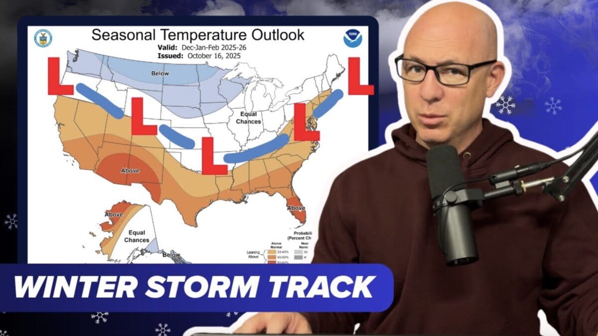
CPC Winter Seasonal Outlook:
The Climate Prediction Center‘s seasonal outlook for December-January-February shows warmer-than-normal temperature odds across much of the United States, though it appears strongest in the South. The Central United States has “equal chances” of above or below average temperatures, leading to the potential for some big swings. The precipitation outlook is showing wetter-than-average in the Ohio Valley, Great Lakes, and Pacific Northwest, while the South is looking at a drier-than-average period.
As the winter progresses from January to April, the warm signal shifts slightly south while a stormy clash zone persists in the North. The south looks like it will continue to remain dry. While the weak La Niña split remains, a big West Coast storm train could quickly flip the pattern.
Current Early Season Signals
Beyond just the weak La Niña weather pattern, cold pools appear to be building over Siberia and Greenland, while warm North Pacific temperatures are cruising into Alaska. Snow coverage in Siberia is expanding quickly, though it’s expanding at a slower pace in Canada.
The short-term model shows a warm-up across the central/eastern United States in early November and a warm finish for those same areas in late November. Once December kicks in, an upper level trough is looking like it will dig into the west, creating a potentially stormier, cooler start to the meteorological winter.
A weak La Niña, easterly QBO, and early cold pools raise the odds of surprise cold blasts and regional snow events throughout the winter, especially in the North and Central United States. Of course, exact city-level snow totals are impossible to forecast at this point.