

AccuWeather’s latest winter forecast, released on October 2nd, 2025, paints a promising picture for snowfall in key areas, but with a “bookend” twist of intense storms early and late in the season. While the West Coast grapples with warmth and dryness, the Midwest and Pacific Northwest are gearing up for some serious powder potential.
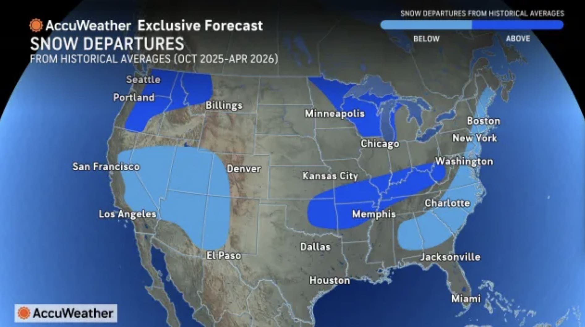
Seasonal Snowfall Potential (October 2025 – April 2026)
AccuWeather’s snow departures map leans on historical averages combined with predicted storm intensity and temperature trends to forecast where snow will pile up highest. Blue-shaded areas indicate below-average departures (less snow than normal), while red would signal above—but the map emphasizes widespread below-average snow overall, with the heaviest relative accumulations in storm-prone interiors.
- Great Lakes and Midwest (Michigan, Wisconsin, Northern Illinois, Indiana): This region stands out for near-to-above-average snow totals, fueled by early December Arctic blasts and intense lake-effect events. Cities like Chicago and Minneapolis could see 20-30% more snow than historical norms in December alone, with totals pushing 60-80 inches season-wide—ideal for resorts like Crystal Mountain and Devil’s Head.
- Ohio Valley and Appalachians (Ohio, Pennsylvania, West Virginia, Western New York): Above-average snowfall is on tap here, thanks to the bookend storm pattern shifting systems from the Plains into these hills. Buffalo is eyeing 90-100 inches (right on average but with heavier bursts), while Pittsburgh and the Alleghenies could rack up 70-90 inches, 10-20% above norms, setting up epic runs at Seven Springs and Snowshoe.
- Northeast and New England (Upstate New York, Vermont, New Hampshire, Maine): Early nor’easters and late-season surges promise the heaviest snow in this zone, potentially 15-25% above average for higher elevations despite urban shortfalls. Boston and New York City might dip below norms due to mixed precip, but Killington and Sugarloaf are forecast for 100+ inches, extending the season into April for backcountry bliss.
- Northern Rockies and Northwest Intermountain (Idaho, Montana, Western Washington, Northern Oregon): Snowy conditions with some above-relative-to-map potential in the Cascades and Bitterroots, where December storms build base layers 10-15% above average before a midwinter lull. Bozeman and Schweitzer could hit 200-300 inches, though overall departures skew neutral amid Pacific warmth.
- Central Plains Transition (Northern Kansas, Nebraska, Iowa): Borderline above-average in storm corridors, with cold snaps delivering 20-40 inches more than norms in targeted events. Kansas City-area resorts like Snow Creek may benefit from 50-70 inch seasons, but expect inconsistency as storms push east.
What This Means For Skiers and Snowboarders
This forecast offers prime opportunities for Midwest and Northeast skiers to score deep powder from day-one storms, while Northern Rockies faithful might need to brace for a drier January before late refreshes. Warmer West Coast vibes could force California crews to road-trip east for reliable turns, but the overall stormy vibe screams extended seasons in the East.