
Report From Powderchasers.com
The upcoming week will be warm and deep. The following week to close out February might be much colder with a return of snow to the PNW, Canada and most of the Rockies and Sierra. Here is our latest recap of the ongoing pattern and current storm underway in the Sierra and Rockies.
We are coming off one of the best storm cycles of the season with blower powder in the Rockies migrating to a wet and deep week ahead. On Saturday I scored my 3rd straight day of epic conditions chasing from Wyoming to Utah. Snowbird reported 8 inches overnight (Light to medium density pow) with 12-14 inch storm totals (Warmer cushion layer fell on Friday). Saturday was one of my top 3 days of the season that skied like a pillow with 8 inches of feathers. Sure, it was a holiday weekend with crowds, but 90% of the folks riding did not know my secret spots.
Below: @powderchasersteve scoring some blower pow at Snowbird on Saturday.

Sierra Fire Hose
Currently on Sunday morning, AR #1 is underway in the Sierra. Telemetry at Palisades at 8K shows 7 inches of snow. Webcams at SugarBowl show 7-8 inches of wet snow at the base. Telem at Mammoth shows 5 inches. Kirkwood just reported 7 inches. Shasta is at 9.
Below: Sugarbowl base has around 7 inches of wet snow Sunday morning. Palisades has similar totals at the top of KT.

Bottom Line Sierra: Significant snow will be falling through midweek in the Sierra with snow levels generally around 6500-7,00 initially Sunday night to Monday. The heaviest burst of snow will be Sunday night to Monday with 1-2 feet above 8,000 feet. Base areas will see significantly less snow. Mammoth Lakes with the higher elevation might be a better chase with greater odds of base elevation snow and slightly better quality at the summits (Won’t open the top). This is not an ideal chase. Snow levels decrease as the week goes on with several moderate waves noted Tuesday/Wednesday (Increasing quality but still dense). Avalanche Danger will be very high with this storm cycle so expect many closures. You might want to consider any chases on Tuesday or Wednesday as the terrain opens and it cools slightly.
Below: U of U ensembles for Mammoth Ski Area (Mid-mountain) show between 20-50 inches are likely peaking on Monday but still rising at a lesser intensity through the 21st (Tuesday). Higher elevation might even score some decent totals from the base to mid-mountain.

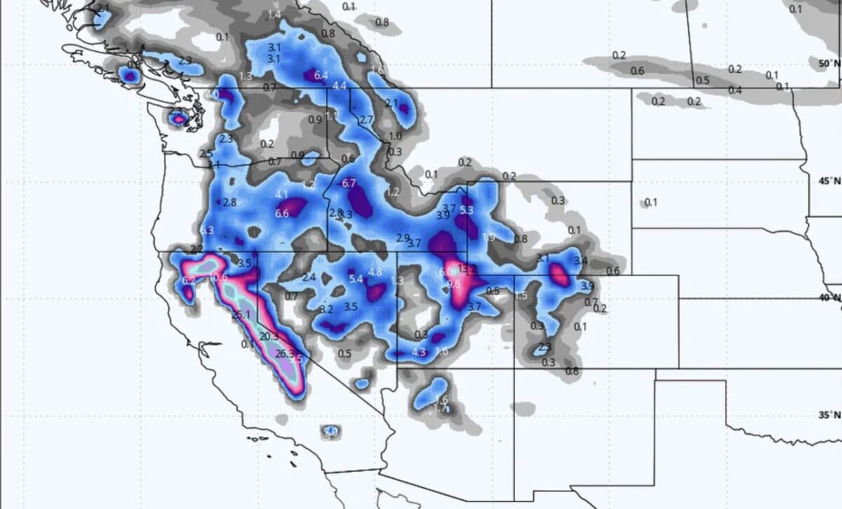
Below: Total snowfall for the Sierra through Wednesday night. We think the southern Sierra or areas on the north side of the lake might see the highest totals, however, everyone will grab 2-3 feet at upper elevations with some isolated 4-foot or higher totals (Our guess is Mammoth Summit). This is a dense storm at its peak on Monday.

Rockies: Utah/Wyoming/Colorado Focus
Snow is falling in Utah currently with rising temperatures. Moderate totals will ensue, primarily in the Cottonwoods by midday Sunday (2-5). Roads are snow-covered in Park City at press time (Sunday morning) with moderate snow showers continuing. Warm temps with a decent moisture fetch will be aimed at the Wasatch Range from Monday night to Wednesday. Elevations above 7000 feet will likely see up to 25 inches of snow, especially in the Cottonwoods. This is a surf storm and will likely create lots of Avalanche warnings.
Below: U of U ensembles for Alta showing peak snowfall from late Monday (February 20) to early Wednesday (February 21). 20 plus inches at mid or upper elevation is reasonable.

Below: Snow-to-liquid ratios mid-mountain at Alta primarily at 12:1 (Dense) increasing to 15:1 towards Tuesday or Wednesday (Medium) as moisture decreases. You won’t see blower with this storm but quality might improve slightly by Tuesday night.

Temps will lower slightly on Tuesday-Wednesday with a chance of some better quality on Wednesday. It’s overall a warm system. As temps cool from Tuesday PM to Wednesday, there is some chance of some lighter density frosting (Moisture is decreasing). Temps overall with this storm will range from the upper 20’s at 8500 feet with mid 20’s at 10K. The bases will range from 31-33. Wednesday might see a few degrees cooler.
Wyoming is up next with some light snow Sunday turning a bit heavier Monday-Wednesday. I don’t expect more than 5-10 inch storm totals in the Tetons with this storm. Snow ratios start near 10:1 and migrate a bit cooler on Tuesday/Wednesday at 15:1. Bottom Line: Dense snow, moderate totals, increasing avalanche Danger with the warming temps.
Colorado is mainly out of the flow, aside from the northernmost mountains where Steamboat could see some light snow initially on Sunday/Monday and a bit more towards Wednesday morning (4-7).
Below: Total snowfall through Thursday next week heavily favoring the Sierra range and Wasatch. Some scattered snow is possible in the PNW. Moderate snow is possible for the Tetons with Idaho wildcards. Northern Colorado might sneak up moderate or higher amounts midweek.

Our gold sponsor Selkirk Powder Guides had nearly 100% of there backcountry terrain open and is reporting good conditions in northern Idaho. They should score additional moderate snow this week with the possibility of heavier snow the following week. They are sold out for most weekends but still have midweek slots available (Cat and snowmobile Touring). Please check them out.
EXTENDED POWDER!
Some of the coldest air of the season is noted to approach the west late next weekend (February 25) into early the following week. While it’s still a week away, there are signals of some significant snowfall to fall in many areas.
Below: Cold front pushing into the west late next weekend into early the following week (February 25-28).

Below: Low pressure entering the west late next weekend or early the following week (February 26).

Below: Fantasy map from February 26-28 showing snow returning to much of the west including Canada with very cold temps. This map shows 24-hour snow totals throughout the period. We are still 7-10 days out so confidence is no better than 30% currently, but I think the trend is favorable.
