


In the wake of the 2009-2010 Wet Season’s strong El Nino, La Nina conditions have been rapidly developing in the equatorial Pacific Ocean this summer. The Climate Prediction Center’s forecast model, as well as other seasonal climate models from various meteorological centers around the world, is now forecasting a moderate to strong La Nina for the upcoming 2010-2011 Wet Season. The Climate Prediction Center currently has a La Nina Advisory in effect with expectation that La Nina conditions will persist through at least early 2011.
Read Full Post for the entire report and additional weather maps.
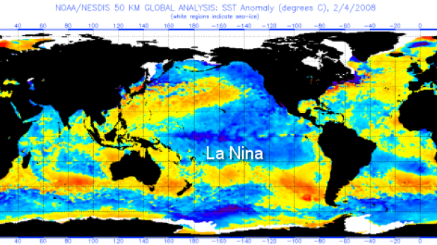
ENSO, or the El Nino Southern Oscillation, is a water temperature cycle that occurs in the equatorial Pacific Ocean. This cycle, which historically cycles every 3-5 years, is tracked most closely in an area known as the Nino 3.4 region of the equatorial Pacific Ocean. The Nino 3.4 region encompasses longitudes from 165 West to 120 West. When average sea surface temperatures (SSTs) in this region reach 0.5C above the historical average, El Nino conditions exist. When they reach 0.5C below the historical average, La Nina conditions exist. For an official El Nino or La Nina “episode” to be declared (such that a period will be referred to as an El Nino or La Nina in the Climate Prediction Center’s historical record) SST anomalies fitting the above criteria must persist for at least 5 consecutive overlapping three month periods. Currently, it is likely to take until January for an official episode to be declared even though one is currently forecast to occur. More simply, once the atmosphere responds to the ocean SST patterns, an El Nino or La Nina begins to affect atmospheric circulations. In the Northern Hemisphere, especially in the Pacific Northwest, El Nino and La Nina have the greatest effect on weather conditions during the winter months.
For most of the Medford Forecast Office’s area of responsibility in northern California and southern Oregon La Ninas tend to yield more predictability for the Winter Wet Season than do El Ninos. In the case of both La Ninas and El Ninos it is believed (and has partially been proved by study) that the greater the SST anomalies with El Nino and La Nina, the greater and farther reaching the effects tend to be. El Nino years tend to be characterized by a more consistent southern storm track into California. When moderate and, especially, when strong, El Ninos bring increased wind and moisture from the south and southwest into coastal areas of southwest Oregon and northern California.
La Ninas tend to be characterized by a more dominant storm track from the west and northwest for our area of responsibility. This tends to increase the chances for above normal precipitation and below normal temperatures from about Mount Shasta north and westward during the autumn and winter, especially during moderate to strong La Nina episodes that are in their first year. In some years these effects push farther east and south, such that the above normal precipitation and normal to below normal temperatures effect the entire forecast area.
Thus, given the global seasonal model SST forecasts, there is an increased probability of a wetter and normal to colder than normal autumn and winter this year. CPC’s charts from past years indicate that these effects are likely to begin in the September-October-November time frame. A look at years with similar climatic indicators shows greater chances of this the later we go into that period, especially in November and possibly as far out as January through March. This, of course, also means increased chances of an above normal snowpack from the Cascades westward, as well as an increased chance of accumulating low elevation snowfall. If this occurs, we should also expect healthy runoff for the spring.
– Brett Lutz
For some of the best day to day weather in and around Lake Tahoe checkout the guys over at Tahoeloco.com. Their weather geek as the best weather forecast out of anyone going. So if you need to know what the weather is going ton be in Tahoe check out Tahoeloco.com for day to day weather forecasts.
Here is a look at NOAA.gov Winter Outlook for 2010/2011

Temperature outlook for October, November and December 2010

Precipitation outlook for October, November and December 2010

Temperature outlook for January, February and March of 2011

Precipitation outlook for January, February and March of 2011
PRECIPITATION: PRECIPITATION OUTLOOK FOR 2010 INDICATES INCREASED CHANCES FOR
ABOVE MEDIAN PRECIPITATION FOR AREAS IN THE NORTHWEST DUE TO LA NINA IMPACTS.
TEMPERATURES: TEMPERATURES ARE ALSO FAVORED FOR NORTHERN ALASKA, WHERE A RELIABLE WARMING
TREND HAS BEEN OBSERVED. BELOW AVERAGE TEMPERATURES ARE FAVORED ALONG THE WEST
COAST IN ASSOCIATION WITH SSTS THAT HAVE BEEN RUNNING BELOW AVERAGE FOR THE
PAST FEW MONTHS.
LA NINA CONDITIONS FAVOR ABOVE MEDIAN PRECIPITATION AMOUNTS IN FOR THE
PACIFIC NORTHWEST
FORECASTER: MIKE HALPERT
SUMMARY OF THE OUTLOOK FOR NON-TECHNICAL USERS
THE MAIN FACTORS WHICH USUALLY INFLUENCE THE SEASONAL CLIMATE OUTLOOK INCLUDE:
1) EL NINO AND LA NINA – WHICH COMPRISE EL NINO/SOUTHERN OSCILLATION OR ENSO.
IMPACTS OF THESE EVENTS ARE SUMMARIZED BY SEPARATING 3-MONTH OBSERVATIONS FROM
3 OR MORE DECADES INTO EL NINO, NEUTRAL, AND LA NINA SETS, AVERAGING EACH
SEPARATELY, AND THEN COMPUTING ANOMALIES. THESE ARE CALLED “ENSO COMPOSITES”,
AND ARE USED TO SUBJECTIVELY MODIFY THE FORECAST.
2) TRENDS – APPROXIMATED BY THE OCN TOOL AS THE DIFFERENCE BETWEEN THE MOST
RECENT 10-YEAR MEAN OF TEMPERATURE OR 15-YEAR MEAN OF PRECIPITATION FOR A GIVEN
LOCATION AND TIME OF YEAR AND THE 30-YEAR CLIMATOLOGY PERIOD (CURRENTLY
1971-2000).
3) THE TROPICAL 30-60 DAY OSCILLATION – SOMETIMES CALLED MADDEN JULIAN
OSCILLATION (MJO) – AFFECTS CLIMATE VARIABILITY WITHIN SEASONS.
4) THE NORTH ATLANTIC OSCILLATION (NAO) AND THE PACIFIC NORTH AMERICAN (PNA)
PATTERNS – WHICH AFFECT THE TEMPERATURE ANOMALY PATTERN ESPECIALLY DURING THE
COLD SEASONS. THESE PHENOMENA ARE CURRENTLY KNOWN TO BE PREDICTABLE ONLY OVER A
WEEK OR SO.
5) THE PACIFIC DECADAL OSCILLATION (PDO) – AN ENSO-LIKE PATTERN OF CLIMATE
VARIABILITY AFFECTING BOTH THE TROPICS AND THE NORTH PACIFIC AND NORTH AMERICAN
REGIONS, BUT WHICH VARIES ON A MUCH LONGER TIME-SCALE THAN ENSO.
6) PERSISTENTLY DRY OR WET SOILS IN THE SUMMER AND SNOW AND ICE COVER ANOMALIES
IN THE WINTER. THESE FACTORS TEND TO PERSIST FOR LONG PERIODS AND ACT AS A KIND
OF MEMORY IN THE CLIMATE SYSTEM.
7) STATISTICAL FORECAST TOOLS – CANONICAL CORRELATION ANALYSIS (CCA), SCREENING
MULTIPLE LINEAR REGRESSION (SMLR), CONSTRUCTED ANALOGUE (CA) AND ENSEMBLE CCA
(ECCA).
8) DYNAMICAL FORECAST MODELS – INCLUDING THE NCEP CLIMATE FORECAST SYSTEM (CFS).
9) AN OBJECTIVE CONSOLIDATION (ABBREVIATED CON IN THE TEXT) OF THE OCN, CCA,
SMLR, ECCA, AND CFS FORECASTS IS USED AS A FIRST GUESS IN PREPARING THE
FORECAST MAPS. THIS TECHNIQUE MAKES OPTIMUM USE OF THE KNOWN SKILL OF OUR
FORECAST TOOLS.
You can read the Full report at noaa.gov/products/predictions/90day