

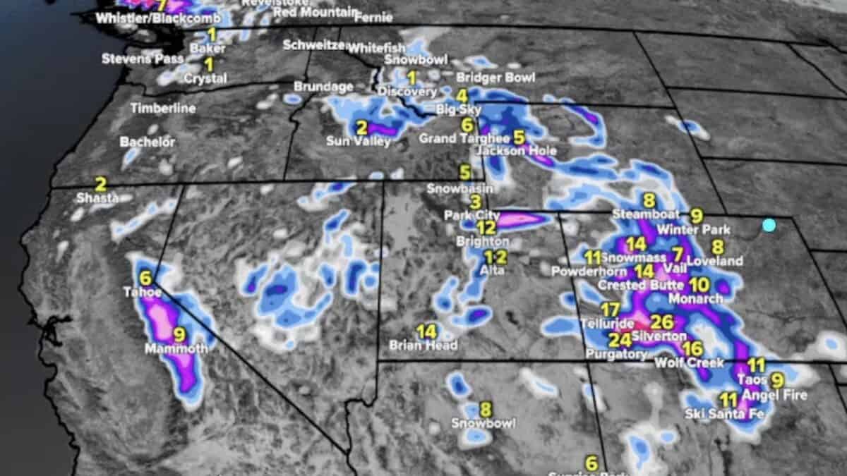
A significant storm system is set to bring widespread snowfall to the West over the coming days, with some ski resorts potentially picking up more than two feet of snow by early next week. Meteorologist Chris Tomer is forecasting particularly impressive totals for Utah and southwestern Colorado, while another storm could deliver additional accumulation heading into November 6 and 7.
The first round of moisture will arrive Friday night into Saturday morning, October 31, as remnants of former Tropical Storm Vance move into the Four Corners region. However, the bigger snowstorm is expected Sunday into Monday, November 1-2, as a powerful low-pressure system and subtropical jet stream combine to push moisture across the Intermountain West.
Utah And Southwest Colorado Could See The Biggest Totals
Tomer identified Utah’s Wasatch Mountains and southwestern Colorado’s San Juan Mountains as two of the biggest winners from the upcoming storm cycle.
Alta, Snowbird, Brighton, and Solitude could see 20 to 24 inches at their upper elevations, with around 10 to 12 inches possible at Alta’s mid-mountain elevation. Brian Head Ski Resort in southern Utah is also expected to pick up more than a foot, with heavier totals possible higher up.
Colorado’s San Juan Mountains could receive 12 to 24 inches, with some of the highest elevations potentially approaching 30 inches. Silverton Mountain is forecast to receive approximately 18 inches at mid-mountain and potentially 30 inches near the summit.
Other Colorado ski areas will see more modest totals. Tomer is forecasting approximately 6 to 14 inches across central and northern mountain zones, including areas west of Vail. Vail itself could receive around seven inches, while Summit County, Loveland, Winter Park, and Arapahoe Basin are generally looking at single-digit totals.
Wolf Creek is another Colorado bullseye, with more than a foot possible from the Sunday-Monday storm.
More Snow Possible November 6-7
Beyond the initial storm, another system could bring additional snowfall to the West around November 6-7. Tomer’s forecast through November 8 includes both storm systems, with several other notable projections.
The Sierra Nevada could pick up around six inches at Tahoe and nine inches at Mammoth, while the Tetons could see 5 to 7 inches at mid-mountain and 10 to 12 inches near the summits. Northern New Mexico could also receive 8 to 12 inches.
One downside is that temperatures are trending warmer than initially expected. However, freezing levels should drop enough to support significant snowfall at higher elevations. Lower elevations, particularly in southwestern Colorado and southern Utah, could see heavy rain creating additional flooding concerns.