
On October 16th, 2025, Direct Weather issued another major update to the 2025-2026 winter forecast, incorporating fresh data indicating a shift toward a weak La Niña pattern rather than the previously expected neutral ENSO conditions. This adjustment, influenced by fall trends and global indicators, promises notable changes in temperature, precipitation, snowfall, and storm activity across the United States. As La Niña begins to assert itself, even weakly, regional impacts are refining, with implications for everything from Northwest storminess to Eastern cold snaps.
Temperature Outlook: Warmer West, Colder East with Nuances
The updated temperature map reveals a southward expansion of above-average warmth along the West Coast, now encompassing more of Oregon, Idaho, California, Nevada, Utah, and Arizona. Southern California, parts of Nevada, and Arizona stand out with the highest confidence for warmer-than-normal conditions, a stark shift from prior predictions. This warmth stems from reduced storminess in the Southwest, allowing clearer skies and higher temperatures.
Conversely, below-average temperatures dominate the Central and Eastern states, where Western warmth funnels cold air eastward. Confidence is strongest in the Northern Plains, Upper Midwest, and Great Lakes, with a fourth shade highlighting potent cold risks there. A subtle Southeast ridge may spare parts of the region from the deepest chills, aligning with recent La Niña-like fall patterns. Northern areas could see temperatures notch even lower than averages, while the jet stream’s upward swing in the East moderates extremes southward.
Precipitation and Snowfall: Stormy North, Dry South
Precipitation forecasts flip classic La Niña script: drier in the Southwest (California, Nevada, Arizona, and Southeast) and wetter northward. The Northwest, Northern Plains, Midwest, Ohio Valley, and Northeast are poised for above-average totals, dipping south into the Plains before rising eastward, a pattern echoing the jet stream’s path.
Snowfall chances follow suit, favoring above-average accumulation where cold and moisture converge. The Midwest, Great Lakes, Northern Plains, interior Northeast, Mid-Atlantic, and Ohio Valley top the list, with precipitation often trumping temperature in these snowy setups. The Southeast retains slight above-average snow odds despite drier conditions, as cold air availability matters more than storms there. Out West, below-average snowfall plagues the Southwest and Sierras due to storm scarcity, while Northern Rockies like Wyoming, Idaho, and Montana may see boosts from frequent systems.
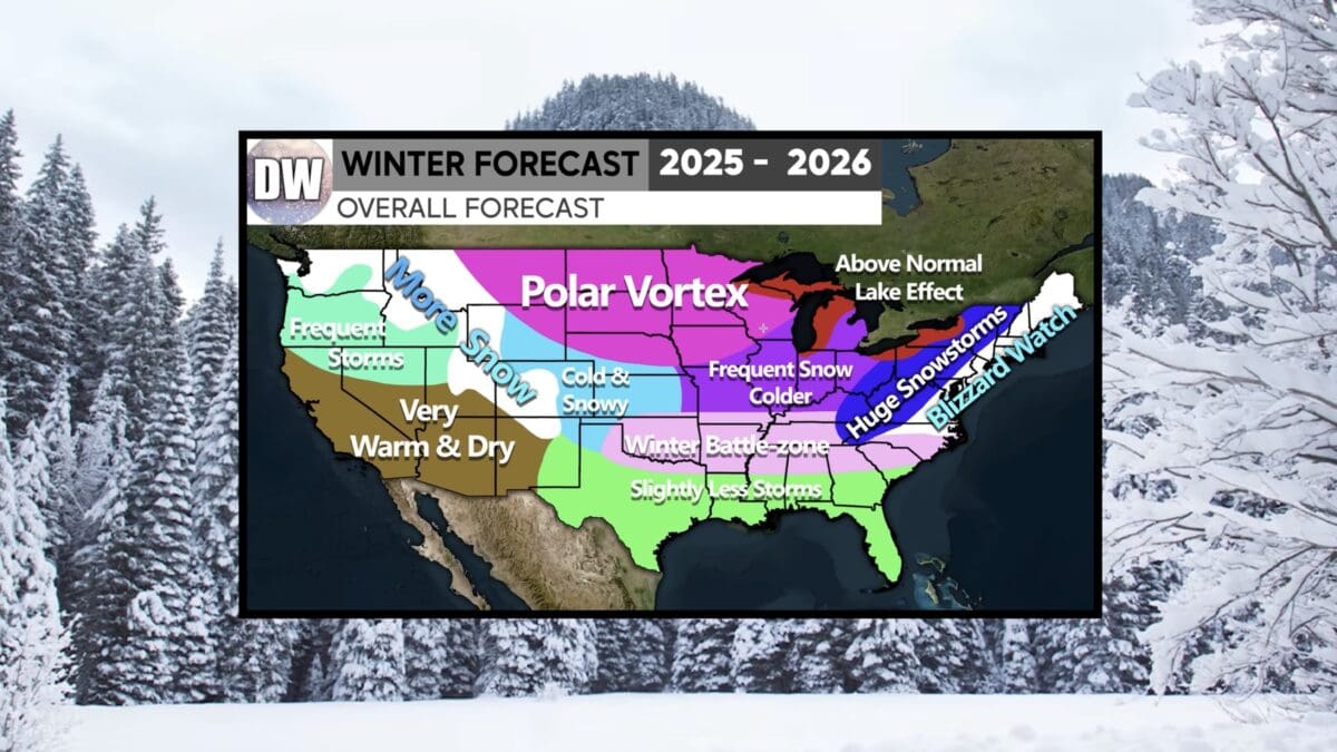
Overall Pattern: Frequent Storms, Polar Vortex Risks, and East Coast Potential
- Northwest: Frequent storms, cloudier and cooler than anticipated.
- Southwest: Very warm and dry.
- Rockies: More snow in northern areas (Wyoming, Idaho, Montana, Cascades), less southward.
- East of Rockies: Cold and snowy at times, more frequent than normal.
- Midwest, Ohio Valley, Great Lakes: Frequent cold, snow opportunities amid recent deficits.
- Central transition: Winter battle zone with ice, sleet, and mixed precipitation.
- Southeast/Gulf: Slightly less stormy due to La Niña ridge.
A developing polar vortex, fueled by Arctic energy buildup, could deliver intense outbreaks reminiscent of last year. Great Lakes’ record-warm waters enhance lake-effect snow potential, akin to 2013-2014 analogs. Appalachians and East Coast face big storm risks, including nor’easters and blizzards. La Niña years have historically produced monsters like the 2010 event, despite typical warmth challenges elsewhere.