

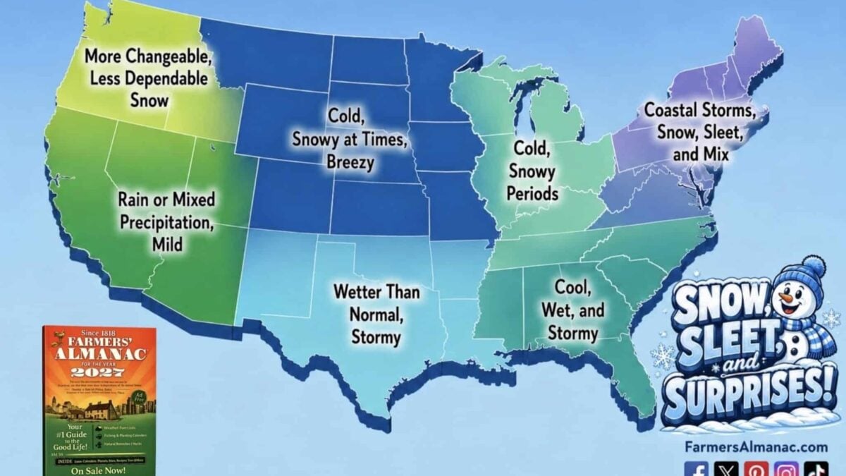
The Farmers’ Almanac has titled winter 2026-2027 “Snow, Sleet, and Surprises”, and the name does the work. This is a season of contrasts: an active, wet southern storm track, quick bursts of snow and cold in the north, and a Northeast that could flip between rain, ice and heavy wet snow on the smallest change in a storm track. Here is what to expect across the country, region by region.
The driver this winter is El Niño, and a strong one. NOAA now puts the odds of a very strong event through the heart of winter above 90%, and gives a 69% chance that the October to December period finishes at or above +2.5°C on the relative Niño index, which would put it ahead of every El Niño in the record back to 1950. In practice that means a loaded southern storm track, a wetter south and southeast, and a northern tier that gets its cold in sharp bursts rather than long settled freezes. More on the ENSO upgrade here.
Temperature: Near Normal Is Not The Same As Mild
The Almanac expects temperatures to average near normal across much of the West, the northern Plains, the Upper Midwest and the Great Lakes, with the Southeast trending cool. That average hides the story. These regions should see fast-moving snow systems, sudden cold snaps, strong winds and short spells of bitter temperatures, separated by mild breaks. NOAA’s September outlook leans warmer than that across the northern tier, which is the main disagreement between the two forecasts this year.
Northeast And New England
The hardest region to forecast. Coastal communities are more likely to see rain and mixed precipitation, while inland areas and higher elevations can expect several rounds of heavy, wet snow, particularly in January and February. Small shifts in storm paths will decide whether a given system is a plowable snow or a washout. Vermont, New Hampshire, Maine and upstate New York are the places to be when the cold and the moisture line up.
Great Lakes And Midwest
Lake effect remains the engine. Expect bursts from Lake Michigan through Lake Ontario, with Cleveland, Buffalo, Erie and Michigan’s Upper Peninsula the usual beneficiaries. Chicago and Indianapolis are more likely to see fast-moving clippers with modest accumulations. Sudden snow squalls and bitter cold, interrupted by milder spells, is the pattern.
Southeast
This region sits squarely in the El Niño storm track and should be cool, wet and stormy. Snow is a secondary threat rather than the main event, but sleet and freezing rain become a real risk whenever a cold surge arrives with the moisture. The northern tier of the region is the most exposed, and even Florida can expect unusual cold snaps.
North Central And The Plains
The most nuanced part of the forecast: cold, snowy at times and breezy, with frequent thaw-freeze cycles that make conditions change fast. The northern Plains stay vulnerable to sudden squalls and Arctic outbreaks. Colorado and the southern Rockies are the standouts, with the Almanac expecting them to fare especially well for snowfall.
South Central
Arkansas, Louisiana, Oklahoma, Texas and New Mexico sit directly in the El Niño corridor and should be wetter than normal and stormy. Dallas, Oklahoma City and Tulsa carry an ice risk whenever cold air arrives with a system, and Louisiana, Arkansas and southern Texas face a flooding risk from the wettest storms. Parts of the southern Rockies within the region may see strong mountain snowfall.
Northwest
More changeable and, in the Almanac’s phrasing, somewhat less dependable. Milder stretches mean valley precipitation falls as rain and the Cascade snowpack may be less reliable than usual. Seattle and Portland should expect variable conditions with mild, damp spells. Direct Weather goes further, forecasting below average snowfall chances for Washington, Oregon, Idaho and western Montana.
Southwest
The clearest winner. Southern California and Arizona should see above normal precipitation, with Los Angeles, San Diego and Phoenix in line for multiple significant rain events between December and March. The Sierra Nevada is the highest-confidence call on Direct Weather’s snowfall map, although snow levels will matter: a warm, wet pattern favours the high country over the base areas. Nevada’s deserts turn wetter but stay mild.
When To Expect The Action
Winter officially begins on 21 December 2026, but the Almanac expects January and February to be the most active months for storms and snow. Read the full Farmers’ Almanac forecast here and NOAA’s latest outlook here.
