

Good morning everyone. The west has been stuck in a transition period of teasing wet snow for the PNW and stubborn temps bringing poor liquid to snow ratios. The Wasatch was teased Thursday with 1-4 inches. The last storm dropped south and brought 7 inches to Sundance and Eagle Point and an impressive 16 inches to Brian Head in southern Utah. Storm skiing would have been epic there. We saw that on the models Wednesday night. That would have been the chase of the week.
The next 7 days puts us into a boring pattern of extreme warming for the west. Temps are going to climb to near freezing at 10K feet in some spots of the Rockies. Seattle will be in the mid to upper 50s this week. Rain showers are likely at lower and even mid to upper elevations of the mountain ranges in the PNW including BC. The warming will continue towards early February when some cold fronts and moisture enter the west. The PNW will be getting crushed with rainfall with less moisture noted for interior BC.
Next Snow?
The models are in full disagreement on the stormy period due from February 1-5. We have high confidence in 6-12 inches for the Sierra range from February 1-2 with some caution flags. Temps start out very warm but finish on the colder side. It’s possible that rain falls initially at the bases (The motto all season) with dense snow at mid or upper elevations. The cold front arrives at the tail end of this storm, so we are hoping that some lighter density frosting coats the lower elevations as moisture weakens and moves east. We don’t expect much if any lake level snow. Higher moisture totals will be falling to the north in the PNW in the form of rain.
Rockies
The highlights we are watching elsewhere for February 2-4 are moisture spreading north into Idaho, Tetons, Montana, Wasatch, Colorado, including the 4 corners. The Ensembles for both the American and European Models show different solutions.
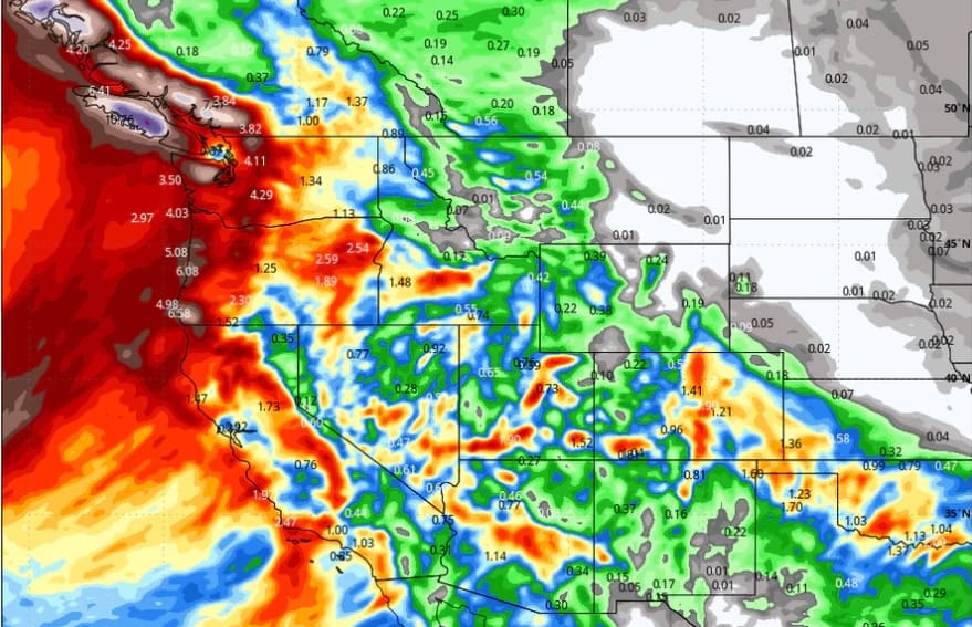
Below: The American Solution shows less moisture in the Northern areas of the Rockies with a faster moving low tracking over the 4 corners. This model also shows some hefty moisture totals for the Front Range Foothills of Colorado, Southern I-25 corridor with S, SE wind direction. 
Below: The European Solution Shows a slower progression of the low resulting in more snowfall for much of central Idaho, Wyoming, Utah, Arizona, Colorado, and New Mexico. Most of the moisture will occur from February 4-6. Caveat: Warm temps may limit totals and provide dense snow initially with a weak cold front due later in the period. Winds appear to be primarily SW, S, SE which is not ideal for many areas in the northern ranges of the Rockies. Sun Valley often does best under southerly flow pushing moisture into the Ketchum Valley (The highlighted area in Idaho is the Ketchum Valley). This will be a dense storm that will likely finish colder.

Bottom Line: Models 7-10 days out will not provide us confidence. We feel relatively confident In a warm storm for the Sierra next Friday (Finishes colder). We also have higher confidence in the 4 corners grabbing decent snowfall totals in the extended ranges. Some of this moisture will work north into the central or Northern Rockies, but to speculate totals is simply too early.
Below: Precipitation will be falling in earnest for southern Utah and Colorado initially by Saturday morning February 3rd. Colder air is noted initially in the south.

Below: Cold front reaches California later Friday evening and spreads out into the 4 corners. Much warmer air is noted north in the Rockies (32F at 10K feet in the Tetons). Southern areas might benefit with moisture and this cold front. Colder air eventually works north into the central and Northern Rockies with some snowfall in the extended period (See above maps)

Below: Total precipitation through February 5th per the American GFS solution. Flooding will be a real possibility later this week and early the following especially in the PNW.
