


From average annual snowfalls to vertical drops– resorts and ski areas make a living off inflating their “mountain stats.”
Related: European Ski Resorts Caught Exaggerating Trail Lengths
MountainVertical.com is here to end that practice by providing what they refer to as True-up Vertical measurements. In its simplest form, True-up Vertical is the measurement of the maximum continuous, consistent vertical drop accessed by a skier or rider.
“In a nutshell, [True-Up Vertical] represents the most vertical distance at a resort that can be achieved on commonly skied, lift-served, continuous fall-line runs.”
And while that may sound like common sense, ski areas across the country have been fudging their vertical drop stats for years by including drops that require multiple lifts, cat tracks, or a single run that adds virtually nothing to the individual’s skiing experience.
Examples of how True-Up Vertical better represents a resort to skiers:
Example 1: Impossible to ski from the highest point to the lowest point (Brian Head, Utah)

Topographic Vertical Drop (conventional definition): 1690 ft – from A to C above
True-up Vertical Drop (from MountainVertical.com): 1135 ft – from A to B above
The conventional topographical definition of vertical drop is the height from highest point to the lowest point, or from A to C above. However, if you look at the layout of the trails, you can see that there is no actual way to ski on a run from A to C.
Instead, A to B is the longest span of continuous run vertical that would be frequently skied when you visit the resort – this is the True-Up Vertical, which is over 500 ft shorter. Claiming that Brian Head has a vertical drop of 1690 ft is somewhat misrepresentative of your skiing experience at this resort because it is impossible to ski that amount at once.
*From a ski resort research perspective, it is more meaningful to know the height between A and B than A and C.
Example 2: The solitary trail that inflates the vertical drop, but adds little to your ski experience (Smuggler’s Notch)
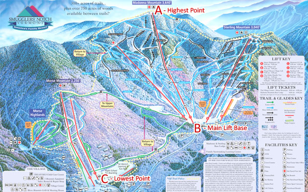
Topographic Vertical Drop (conventional definition): 2564 ft – from A to C above
True-up Vertical Drop (from MountainVertical.com): 2088 ft – from A to B above
The conventional definition of vertical drop is the height from highest point to the lowest point. However, when skiing down from this summit, it becomes clear that continuous fall-line runs are between and A and B, not between A and C, based on the mountain’s layout.
B to C is actually just a single long green traverse away from the main lift area, which inflates the resort’s vertical drop by an extra 500 ft, but is not part of the primary mountain face and is rarely skied from the summit, therefore not counted as part of the True-Up Vertical.
*From a ski resort research perspective, it is more meaningful to know the height between A and B than A and C.
Example 3: The highest and lowest points are only connected via a catwalk or long traverse (Sunday River)

Topographic Vertical Drop: (conventional definition): 2317 ft – from A to C above
True-up Vertical Drop: (from MountainVertical.com): 1758 ft – from B to C above
Many resorts with numerous peaks have highest and lowest points that are not well connected and require a long traverse to get across. In this example, Sunday River is organized with many peaks along a diagonal ridge, where the highest peak and the lowest base are definitely not along the same fall line, and may even require considerable poling to get across.
In these cases, the True-Up Vertical is the tallest fall line offered by the resort. For Sunday River, it is from the top of Locke Mountain to the lowest base area, or from B to C. This is about 550 ft shorter the conventional definition of vertical drop, but it represents the most drop a skier would typically ski in a run.
*From a ski resort research perspective, it is more meaningful to know the height between B and C than A and C.
Example 4: The highest point is not lift-served and requires hiking (Marmot Basin in Alberta)

Topographic Vertical Drop (conventional definition): 2869 ft – from A to C above
True-up Vertical Drop (from MountainVertical.com): 2240 ft – from B to C above
On many mountains, the highest point is not lift-served and requires you to hike. We only include the lift-served portion as part of the True-Up Vertical, because lift-served runs are more frequent and repeatable when you’re out skiing, while hiking to the top for a run is generally more of a one-time thing, given the time and effort required.
*From a ski resort research perspective, it is meaningful to know both the height between B and C and A and C.
Example 5: True-Up Vertical is exactly the same as Topographical Vertical (Jay Peak)

Topographic Vertical Drop (conventional definition): 1936 ft – from A to B above
True-up Vertical Drop (from MountainVertical.com): 1936 ft – from A to B above – exactly the same in this case
For Jay Peak, the True-Up Vertical Drop number is exactly the same as with the conventional definition of Vertical Drop, because the highest and lowest points are fully connected by numerous continuous fall-line runs. In other words, if you were to visit Jay Peak, you would make regular ski runs from the highest to lowest points on the resort.