

By -Peter Nave
This story is about a serious mistake, my mistake really, but one that is far too dangerous and common in the Whistler area. During the last week of February, Whistler Blackcomb received well over two feet of unusually dry, new snow and both mountains were primed for shredding. Being both the Canadian Universities’ “reading week” break and the US’s President’s Day break, Whistler Blackcomb was so busy that although powder was burying the mountains, lift lines made the day’s runs few, and the new snow well tracked.
For those of us familiar with Whistler Blackcomb, Whistler Peak’s Khyber Pass area is a favorite spot for putting powder in our faces from the very top of the resort to its base at the Creekside Gondola over 5,000 feet below. For my friends and myself this week was no exception.

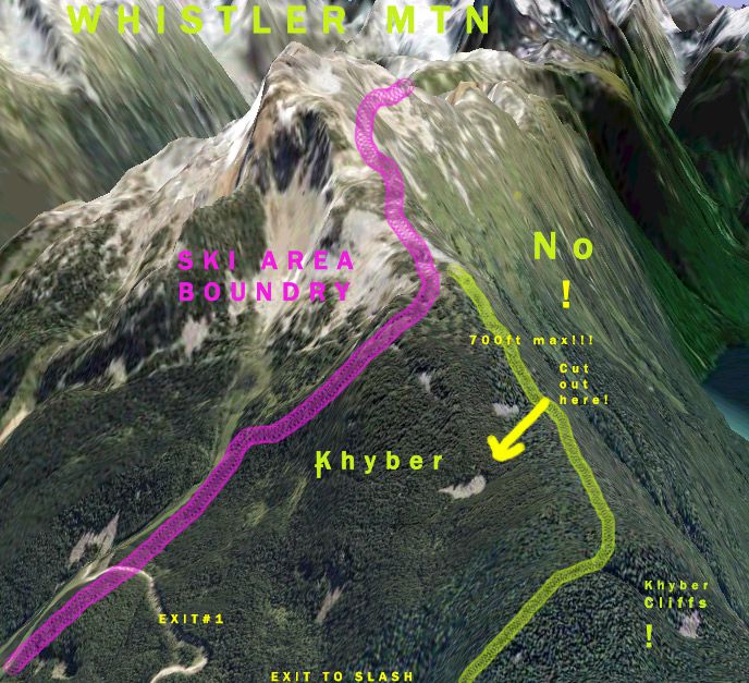
Khybers is just outside the ski area boundary and begins at an unmarked but well visited hut called the Stu inn. Most riders follow the day’s first tracks down slope and to the right until a well used road takes you back to the maintained runs near the mountain’s base. Khybers is a long, broad and wild run between the ski area boundary and a remote valley on skier’s left. It is without any signs and Whistler Search and Rescue recommends that skiers: “Don’t go unless you are with someone that knows where they are going 100%. A lot of people will tell you they know where they are going…Find someone that has been here for 5+ seasons to show you around.” (This is foreshadowing).

After a very long day of skiing that Saturday, including several sidecountry runs from top to bottom, my friends and I set out to make a last tired lap down Khybers to our car at the base. While waiting for these friends I ran across some life long Whistler locals who claimed that if I followed their tracks I would be taken to a fresh stash and then back to the main area. They then disappeared into a cloud of powder as I continued to wait.
After giving up on my friends I followed the recent tracks, feeling reassured by the dozens of tracks between me and the dangerous Cheakamus Valleyto my left. I spent the next five minutes enjoying some of the only powder left on the mountain and thinking about how lucky I was when the tracks took an abrupt 90-degree turn to my right. Believing this to be the exit that was described to me I continued on. After another minute or two, I came to a clearing and my heart sank. I was looking across a valley to another heavily forested mountain and not down at Whistler’s neighborhoods. What’s worse, I had looked out at this before. Last season I accidentally skied into the Cheakamus Valley, and after navigating down to the valley floor with a lot of luck, had to walk over 8km to the highway.
With almost no faith in the two other locals I’d run into near the top, I had two choices: descend and hope I’d be as lucky as last time, or follow the only two tracks in sight and find their creators. As I continued along the tracks I began to hear panicked yells and after hiking uphill a bit came across the two locals. One told me that they were completely cliffed out from below, and I saw the other huddling below some downed logs. I admitted to them that I had some idea where we were and ironically convinced them to follow me as I broke trail up our tracks. After a short amount of hiking I discovered what I thought was a suitable place to descend, having seen Whistler Search and Rescue’s maps of the many impassable cliffs and waterfalls in the area known as the Khyber Cliffs.

Some time, several deep gouges in my 5 day old skis, and a month’s worth of adrenaline later we reached the logging road that connects highway 99 to the North with Cheakamus Lake to the South. My companions had brought no food, no extra clothes, no avalanche safety gear and truthfully no backpacks or bags of any kind. Luckily we discovered that we were only 5km from the highway and as I put on my own skins from my bag, two other lost snowboarders arrived from the direction of the lake. Checking that everyone was prepared for a slow 5km walk, I gave them directions to the highway, the sun came out and I departed to meet the friends that had long been waiting at the car.

As I arrived at the highway at around 4:30pm I stepped onto a BC transit bus and headed back to the resort. On the bus I met some visitors from Spain who quickly explained that they too had been sucked into the Cheakamus Valley by going too far skier’s left. Although my ordeal had taken over an hour and a half, these two had left the peak at 11:30 that morning, taking them over 5 hours to get out! Much like the first two that I had met, they had thought hard about spending the night under some logs and waiting for help completely soaked and alone. Luckily these two foreigners had with them a GPS unit, which they credited with saving their lives. Their skis and boards were not as lucky, as both lay broken on the floor of the bus.
Being an expert backcountry skier, a guide, and an idiot that has repeated this mistake I should not have been surprised that others would do the same. Nonetheless, chancing across six others in such a large area and seeing the volume of tracks leading into the valley, I am shocked at the frequency of this serious and life-threatening blunder. Over the years, Whistler Search and Rescue has saved many riders stuck on top of the various cliffs or simply lost in this large and rarely visited area. I have written this article to promote awareness over the ease that this mistake can be made and cannot stress enough the dangers that exist in this area that I, and those I have come across have avoided out of shear luck. Even when things turn out okay, an experience like this is always very humbling.

If you try to enter Khybers, do not travel more than 700ft to the left of the Stu inn hut at any point. There is a tall radio tower on a shallow ridge that can be seen to the Northwest of the area boundary at the Stu inn, in a pinch stay well right of this. Always travel with those who have an expert knowledge of the area and make sure they know you’re new to the Khyber area as it is very easy to get separated from partners quickly. Please read Whistler Search and Rescue’s blog article about this area and the serious dangers that exist outside of all of Whistler’s boundaries at http://whistlersar.blogspot.com/.
Special thanks to Whistler Search and Rescue, which can be found at: www.whistlersar.com/.
About the author: Peter Nave is a guide from Southeast Alaska who moved to BC to attend the University of British Columbia in Vancouver. He spends his winters between Whistler and Vancouver.