

Report From Powderchasers.com
Kiss the wildfires goodbye in the Pacific Northwest as the first snow of the season will be in the Cascades as early as Monday. Several light to moderate events will be moving into the PNW beginning a skiff of snow to most mountains by late Monday. Heavier snow is likely Tuesday/Wednesday especially the southern zones near Crystal. The models are going ballistic for Mount Rainier next week with our best guess of 2 feet plus. One NOAA computer generated zone forecast shows 50-100 inches of snow for higher elevations of Rainier. Most ski areas will see light or moderate amounts from mid mountain and up with a trend for the higher amounts in the southern Cascades of WA and northern Cascades of Oregon (4-9). “It’s going to be waves of light or moderate snow with breaks between 3 different systems for most of the week”


Models are bringing a decent fetch of moisture over the northern Rockies next week. The highest amounts will most likely be found in southern Montana including Bridger Bowl, Big Sky, Red Lodge, and the Great Divide ski area.

Areas south of Montana should fare slightly better than last week with perhaps 5-10 inches (Peaks) in many spots of central Idaho (Lost Trail) with less towards Sun Valley and north to Lookout Pass. Snow levels will start out high 8500 and lower to perhaps 6-7,000 feet by Wednesday night. We like the odds of deeper snow for mid week versus early week especially the Tetons or Central Idaho.
The Tetons stand an advantage with higher elevations so expect another teaser for Jackson Hole and Grand Targhee especially Wednesday night/Thursday. Expect rain at the base and wide variations of amounts at the summits (North Tetons favored).
Utah is on the tease of light to moderate snow in the northern areas of the State (Perhaps Beaver Mountain will see a decent taste) beginning Tuesday-Thursday. Light or moderate snow is possible further south mid or late week especially the Uinta’s. Colorado earns colder air and some light snow by the end of next week but its a wildcard at this point.
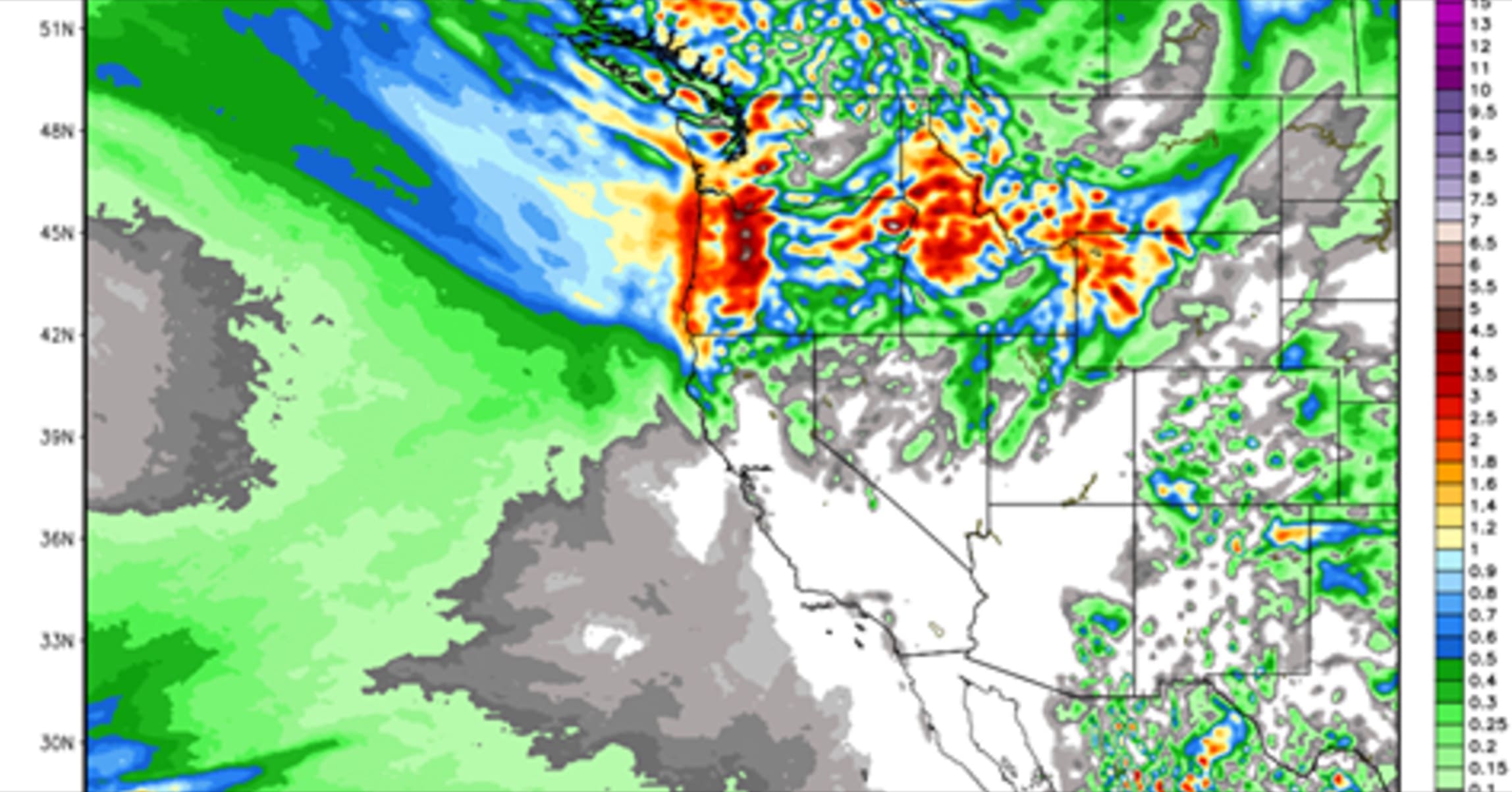
Below: Large area of 6-11 inches in the Rockies with higher amounts in northern Wyoming and southern Montana through Friday! Map: Weather Bell through Friday AM.

The bottom line is that 3 systems next week each progressively colder will set up for some decent amounts of snow for many areas of the northern Rockies. The PNW will gain the benefits of rain/snow squashing many of the wildfires beginning Sunday night and continuing in waves through Thursday.
It’s not even fall yet! That starts on Friday! The latest Climate Predictions show a weak La Nina to start the winter. Most of the Rockies are fairly neutral with this pattern (Sit in the middle of the 2 patterns) however if La Nina strengthens (Wildcard) it tends to focus slightly higher odds of northern areas seeing more snow (PNW, Northern or Central Rockies). I don’t put lots of confidence in forecasting snowfall amounts based on purely La Nina or El Nino since theres plenty of exceptions that occur. It’s worth talking about for the hype however so thats the only reason I mentioned it.
Follow Powderchasers on Facebook and Instagram. Sign up for custom powder alerts at www.powderchasers.com. Thanks to our 28,000 followers on FB and nearly 7,000 on Instagram.
Powderchaser Steve