

January-February-March 2026 Seasonal Temperature Outlook: NOAA’s latest forecast predicts a cold winter for the Pacific Northwest and the Northern Rockies
As the first hints of fall chill are settling in, we’re already eyeing the temperature forecast for this upcoming winter. The National Oceanic and Atmospheric Administration’s (NOAA) Climate Prediction Center dropped its latest outlook for the 2025 – 2026 winter season, and it’s got some frosty news for certain spots. While much of the U.S. braces for milder conditions, the Pacific Northwest and Northern Rockies are tipped for the coldest winters, with enhanced chances for snow to match.
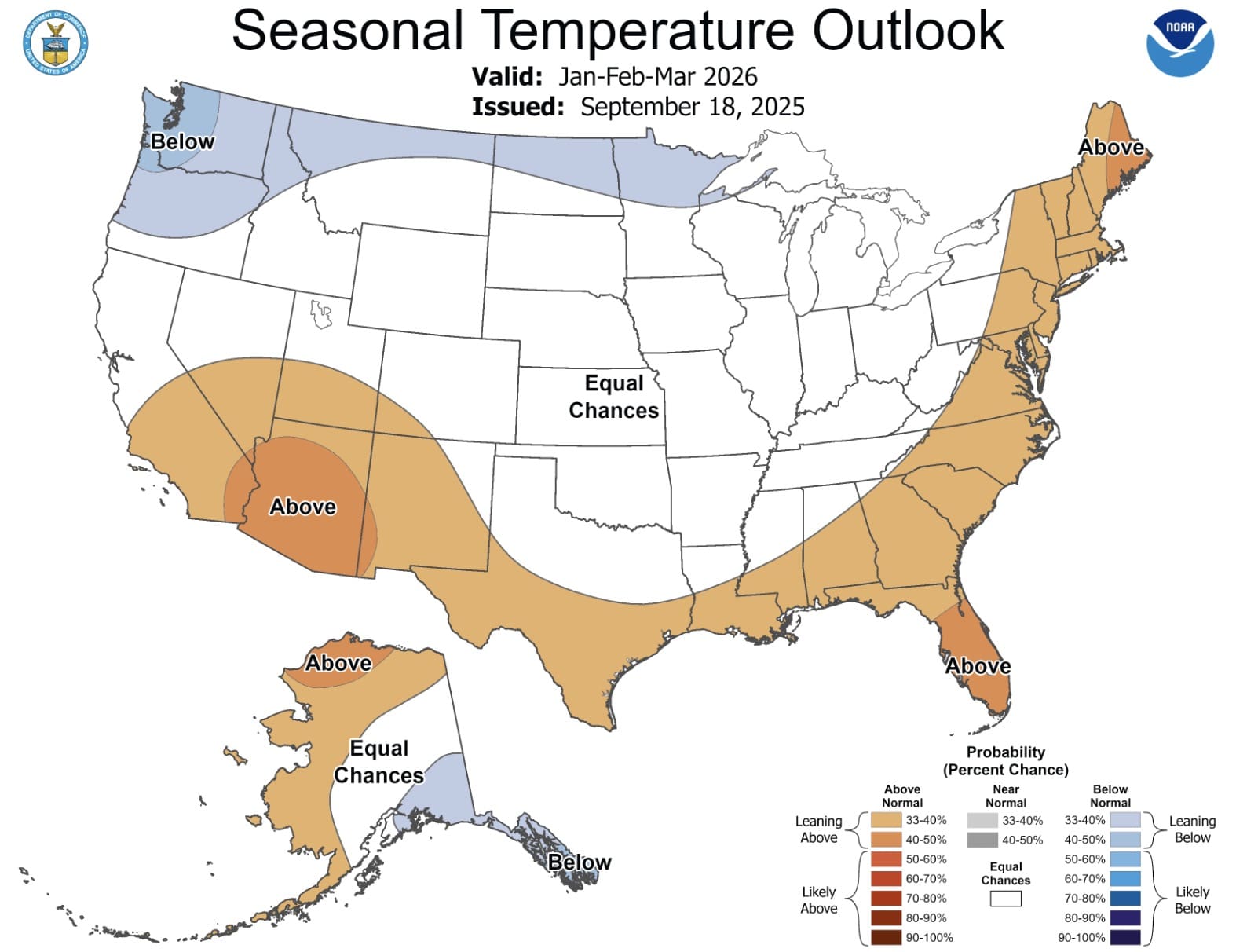
Seasonal Temperature Outlook (January – March 2026)
NOAA’s temperature forecast paints a divided picture across the U.S., with a clear tilt toward below-average chills in the northernmost reaches. These cooler pockets stand out against warmer trends elsewhere, boosting the odds for sustained cold snaps and wintery vibes. Here’s the breakdown for the regions poised for the deepest freezes:
- Pacific Northwest (Washington, Oregon, western Idaho, western Montana): Leaning below normal (33-60% probability). Expect a cooler winter with potential for increased frost or snow.
- Northern Rockies and Plains (Eastern Montana, North Dakota, Minnesota, northern Wisconsin): Leaning to likely below normal (40-70% probability). Colder temperatures are favored, raising the likelihood of frozen precipitation.
- Alaska (Southern and Western areas): Leaning below normal (33-40% probability). Cooler conditions may dominate these populated southern zones, adding to the chill factor.
For context, the rest of the map skews warmer: the Southwest, Southeast, and Northeast all lean or likely above normal (33-90% probabilities), while the Central U.S. sits at equal chances. This north-south split could make for some cold fronts barreling down from Canada.
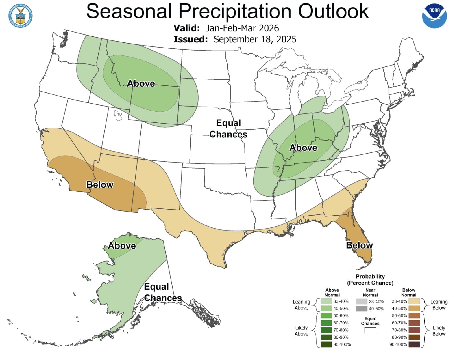
Seasonal Precipitation Outlook (January – March 2026)
Pairing those subzero temps with moisture is key for snow lovers, and NOAA’s precipitation map aligns nicely in the cold zones. While the broader U.S. shows a patchwork of wetter and drier spots, the coldest regions get a favorable nudge toward above-average wetness—translating to deeper bases on the mountains.
- Pacific Northwest (Western Washington, Oregon, western Idaho, western Montana): Leaning above normal (33-50% probability). Wetter conditions are favored, potentially boosting snowpack.
- Northern Rockies and Plains (Eastern Montana, North Dakota, South Dakota, northern Wyoming): Leaning to likely above normal (40-70% probability). Increased precipitation, likely as snow, is expected.
In Alaska’s southern and western areas, odds are equal for precipitation, so the cold could still deliver without guaranteed flurries. Elsewhere, things dry out in the Southwest (likely below normal, 60-80%) but perk up in the Northeast (leaning above, 33-50%).
What This Means For Skiers & Snowboarders
If you’re chasing the coldest, snowiest winter, pack your bags for the Pacific Northwest and Northern Rockies. Don’t count on the same outlook in the warmer Southwest or Northeast, where drier, milder weather might lead to thinner cover and earlier thaws.