
La Niña Forecast for Fall and Winter 2025/26: What It Means for Americans
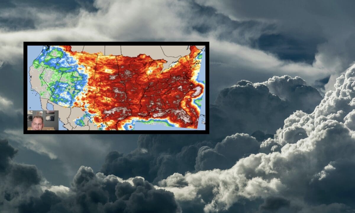
Today, we have the latest information on the emergence of a weak La Niña. We also have the La Niña weather forecast and what that means for upcoming weather in the United States. As we transition from summer to fall and winter 2025/26, the forecast indicates that weather patterns across the U.S. are set to shift. This is due to the emergence of a weak La Niña. According to a recent video from POW Ponder on Weather on YouTube, this climatic phenomenon will influence temperatures, precipitation, and severe weather events across the country. With this La Niña weather forecast, we’ll break down what La Niña means for Americans. We’ll discuss how it will impact different regions and what you can expect in the coming months.
What Is La Niña?
La Niña is a climate pattern characterized by cooler-than-average sea surface temperatures. This occurs in the central and eastern equatorial Pacific Ocean. It’s part of the El Niño-Southern Oscillation (ENSO) cycle, which also includes El Niño (warmer waters) and ENSO-neutral phases. According to the POW Ponder on Weather video, we’re moving from an ENSO-neutral phase into a weak La Niña. It is expected to take hold by October 2025 and persist through the winter.
La Niña typically influences weather patterns by altering the jet stream, leading to distinct regional impacts across the U.S. For Americans, this means changes in temperature, precipitation, and the likelihood of severe weather events like tornadoes and hurricanes. The La Niña weather forecast is particularly influential in preparing for these shifts.
Key Weather Impacts of La Niña for Fall and Winter 2025/26
1. Temperature Trends
La Niña often brings cooler and wetter conditions to the northern U.S. Meanwhile, the southern states experience warmer and drier weather. The POW Ponder on Weather video highlights that the weak La Niña will likely result in:
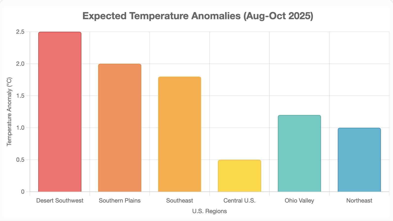
- Above-average temperatures are expected across the southern U.S., including the Desert Southwest, Southern Plains, and Southeast. These temperatures are particularly expected in August, September, and October.
- Slightly above-average to normal temperatures in the central U.S., with the Ohio Valley, Mid-Atlantic, and Northeast seeing warmer conditions.
- Cooler shots from the Northwest diving into the Southeast by late fall and early winter, especially in November and December.
To illustrate, here’s a chart showing the expected temperature anomalies for August through October 2025. This is in relation to the La Niña weather forecast:
2. Precipitation Patterns
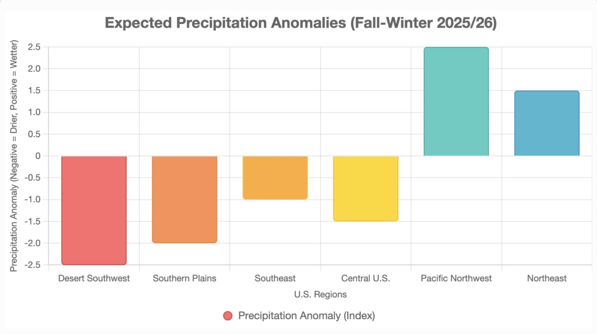
La Niña tends to reduce the activity of the subtropical jet stream, leading to drier conditions in the southern U.S. The video notes:
- Drier periods in the Desert Southwest, Southern California, Oklahoma, Texas, the Southeast, and Florida. These conditions will arrive as we head into late fall and winter.
- Increased rains in the Pacific Northwest starting in November and December. An active polar jet will bring more precipitation to northern areas.
- Heavier rains along the eastern seaboard and the Gulf Coast due to tropical systems.
These patterns could exacerbate droughts in the south while providing relief in the north. This is emphasized by the La Niña weather forecast.
La Niña’s Impact on Skiing and Snowboarding in the US
For skiers and snowboarders, a weak La Niña winter 2025/26 could mean exciting opportunities in some regions. However, it may pose challenges in others, based on historical patterns and current forecasts. With about a 50% chance of La Niña developing between October 2025 and January 2026, the jet stream shifts are expected. These shifts favor northern and northwestern U.S. resorts with above-average snowfall. However, southern areas may see reduced snowpack as indicated in the La Niña weather forecast.
Related Post: NOAA Issues Official Winter Weather 2025 / 2026 Prediction
Regional Breakdown for Skiers and Snowboarders
- Pacific Northwest: Expect above-average snowfall, making resorts like Mt. Baker and Crystal Mountain top destinations. The southward shift of the polar jet stream should boost snow totals, ideal for powder days.
- Northern Rockies: Prime for heavy snow, with spots like Whitefish, Big Sky, Jackson Hole, and Grand Targhee likely to see increased precipitation. This could lead to excellent conditions for backcountry skiing and resort runs.
- Utah and Central Rockies: Utah sits in a transition zone, where storm tracks from the Northwest could dip south, potentially bringing banner snow years similar to 2022-23 (over 900 inches at Alta). However, southern Utah and Colorado might have average to below-average snow, so monitor resorts like Park City and Snowbird closely.
- Southern Rockies and Southwest: Warmer and drier conditions could challenge resorts in Arizona, New Mexico, southern Colorado, and Tahoe, with lower snowfall and greater reliance on snowmaking.
- Northeast and Great Lakes: Increased lake-effect snow and colder air could enhance conditions in upper New England (e.g., Vermont, New Hampshire) and Midwest resorts like Boyne Mountain and Crystal Mountain. This might mean more stormy days but solid base depths.
If La Niña doesn’t fully materialize and we stay neutral, patterns could be similar but with more variability, still favoring the Northern Rockies and New England for troughing and cold air pockets. Skiers should prepare for potential early-season starts in the north and keep an eye on updates from NOAA and meteorologists.
Here’s a quick comparison table of expected snowfall for key ski regions:
| Region | Expected Snowfall | Top Resorts to Watch | Notes |
|---|---|---|---|
| Pacific Northwest | Above Average | Mt. Baker, Crystal Mountain | Boost from polar jet stream; great for powder hounds. |
| Northern Rockies | Above Average | Jackson Hole, Big Sky | Heavy dumps possible; ideal for advanced terrain. |
| Utah/Central Rockies | Average to Above | Park City, Alta | Transition zone benefits; historical big years under La Niña. |
| Southern Rockies | Below Average | Taos, Aspen (southern areas) | Drier; rely on snowmaking for base. |
| Northeast | Above Average | Killington, Stowe | Lake-effect boosts; more storms but colder temps. |
| Great Lakes/Midwest | Above Average | Boyne Mountain | Increased precipitation for family-friendly slopes. |
For more details on the forecast, check out this insightful video from POW Ponder on Weather: Watch the Video.