
Lake Tahoe, California – A major winter storm is lining up across the West, and it’s looking like the kind of system that could deliver some of the best powder days of the season—especially for the Sierra Nevada. Forecasts indicate a powerful multi-day setup, with heavy snow, strong winds, and significant travel impacts likely as the storm moves in. This isn’t shaping up to be a quick hitter either. It’s a sustained pattern that could keep delivering snow through multiple rounds, and skiers and riders should be paying close attention.
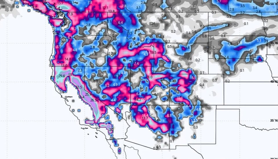
The biggest headline right now is the Sierra Nevada, where Powderchasers has issued what they’re calling a “Snorkel Watch,” meaning snowfall totals could reach truly ridiculous levels. Their forecast suggests the Sierra could see 4 to 6 feet of snow at higher elevations, with the potential for even more if the storm track stays favorable. Such accumulation over a short period could completely transform conditions at resorts such as Palisades Tahoe, Kirkwood, Heavenly, and Mammoth. If the storm delivers anywhere close to what models are showing, we could be talking about waist-deep days.
This system isn’t just targeting California either. As the moisture pushes inland, areas like Utah and the Rockies are expected to benefit as well. Powderchasers notes that places like the Wasatch could see solid snowfall totals, especially at higher elevations, with Park City potentially picking up around 9 to 15 inches above 8,000 feet. Colorado and other parts of the Rockies could also see meaningful snow, though the biggest jackpot still appears to be aimed at the Sierra. Even if the totals aren’t as extreme farther east, it’s still enough to freshen things up and improve conditions across a wide swath of mountain terrain.
Of course, with heavy snow comes big consequences. Heavy snowfall combined with wind can lead to whiteout conditions, lift closures, and significant delays entering mountain towns. Anyone planning to travel through the Sierra should be prepared for chain controls, road closures, and slow-moving traffic, especially over major passes. If you’re chasing powder, now is the time to check road conditions, pack emergency gear, and plan ahead. Resorts may also see terrain closures as patrol works through avalanche mitigation, which will be especially important if snowfall totals accumulate quickly.
Avalanche danger will be a major factor in the backcountry as well. Any storm that drops multiple feet of snow in a short period will significantly increase instability, and conditions can shift rapidly. If you’re heading beyond resort boundaries, this is one of those periods where checking the avalanche forecast isn’t optional.
Bottom line: this storm has the potential to be a big one. The Sierra is in the crosshairs for what could be multiple feet of snowfall, and surrounding mountain regions should see fresh snow as the pattern unfolds. If you’ve been waiting for winter to finally show up in full force, this might be the week. Stay safe, drive smart, and if you’re lucky enough to score the goods, send us your storm shots.