
Winter Weather Forecast / Prediction / Outlook 2025-2026: Updated Snowfall Outlook Across the U.S. Direct Weather releases their updated winter forecast as meteorological winter hits its stride.
Attention all skiers and snowboarders, now that we’re officially into meteorological winter, Direct Weather has released an updated snowfall forecast for the 2025-2026 season. The forecast confirms early-season trends that have already delivered significant snow and frigid temperatures across several portions of the United States since Thanksgiving.
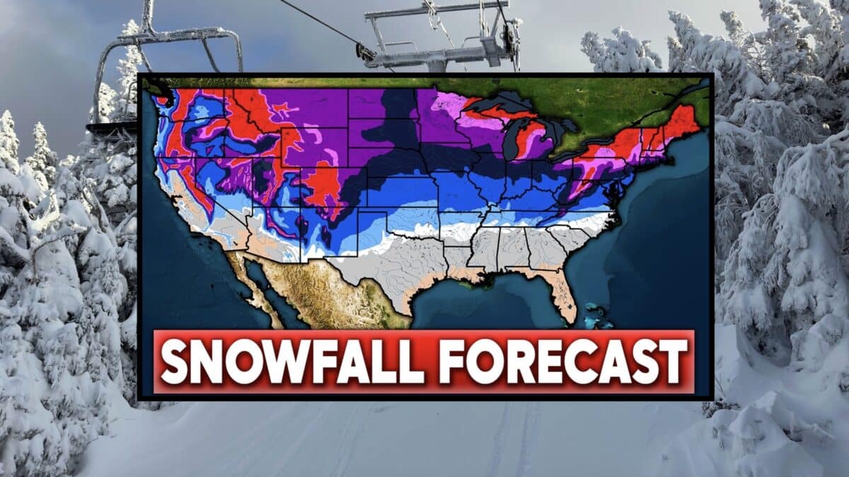
Winter Snowfall So Far
The early winter pattern has largely validated Direct Weather’s initial predictions. A hyperactive clipper track has dominated the northern plains, upper Midwest, and Great Lakes, with systems arriving every two to three days. These Alberta clippers have occasionally dipped further south, bringing multiple snowfall events to areas typically on the fringe of winter weather.
The temperature forecast has also stood truel, with a western ridge (positive PNA pattern) redirecting Arctic air into the central and eastern states. Recent polar vortex disruptions have unleashed exceptional cold, with temperatures running well below normal from the Plains through the East Coast.
The Precipitation Pattern
Direct Weather anticipates continued action along the Northwest coast, though most Pacific moisture will remain confined to that region. The clippers will continue, maintaining an active pattern across the northern tier. However, the southern jet stream has proven more vigorous than expected for a weak La Niña winter, potentially due to a gradual transition toward neutral conditions or even El Niño later in the season.
This enhanced southern jet increases the probability of nor’easter activity along the East Coast and raises the possibility of rare snowfall across Deep South locations. The forecast suggests this southern track could become increasingly important as winter progresses, particularly for coastal Mid-Atlantic and Northeast regions.
Snowfall Chances: Above or Below Average?
Below Average: The Southwest faces reduced snowfall chances due to warmer temperatures and decreased precipitation. Even the Sierra Nevada, where precipitation typically falls as snow, will see less accumulation simply due to fewer storms. Confidence in below-average snowfall increases as you move deeper into the Southwest.
Above Average: The Northwest benefits from above-average precipitation, landing in the above-average snowfall zone. However, the biggest winners are the northern Plains, Midwest, Great Lakes, and virtually the entire East Coast.
The Mid-Atlantic and Northeast face a double threat, with clippers tracking offshore and intensifying into Miller B nor’easters, plus the possibility of classic Miller A nor’easters tracking from the Gulf region. As the winter potentially trends toward neutral ENSO or even weak El Niño conditions, these Gulf-origin storms could become more frequent, bringing major snowstorms up the entire Eastern Seaboard.
What to Expect
Most regions won’t see massive individual storms but rather continuous small to medium snowfall events. The exception lies along the East Coast, where major storms remain possible especially later in winter. Regardless, expect active, cold conditions with snow systems consistently moving through, potentially intensifying as the season progresses. Moral of the story, these types of long range winter forecasts are great for skiers and snowboarders hoping to plan far ahead, but are subject to change with dynamic weather patterns. Make sure to check local forecasts for more accurate weather predictions.