
Winter Weather forecast/outlook/prediction for winter 2025 / 2026
Today, we have the last and final winter weather prediction from Direct Weather. The major change to the forecast is that we are now expecting a weak La Niña to transition to ENSO-neutral, which will affect temperatures and snowfall across North America. This is a change from the enso-neutral conditions that NOAA was forecasting just a few months ago.
“La Niña conditions are present and favored to persist through December 2025 – February 2026, with a transition to ENSO-neutral likely in January-March 2026 (55% chance). NOAA
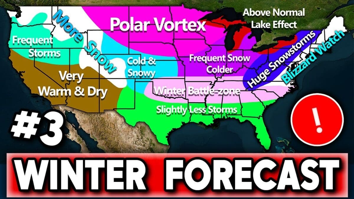
Winter 2025-2026 Forecast Breakdown by Region
This breakdown is based on the third update to the winter forecast, incorporating emerging weak La Niña influences (opposite of El Niño, leading to cooler Pacific waters and shifts in storm tracks). The forecast emphasizes changes from prior updates, with a focus on temperatures (compared to historical averages), precipitation, snowfall potential, and overall conditions. Key themes include a warmer West, colder East/Central areas, a northward-shifted jet stream favoring northern storms, and a potential Southeast ridge that could reduce southern activity. Confidence is higher where patterns align with fall trends and analogs (e.g., 2013-2014 winters).
Northwest (Washington, Northern Idaho, Montana)
- Temperatures: Below average, cooler than previously expected due to increased storminess and cloud cover from La Niña effects. Northern areas may see more persistent chill.
- Precipitation: Above average, with periods of frequent storms— a big shift from drier prior forecasts. Not constant, but wetter overall.
- Snowfall: Above average chance, especially in higher elevations like the Cascades. Storms will drive accumulation.
- Overall: Frequent storms, cooler and wetter than average. Good setup for winter activities, but watch for flooding/avalanche risks. Polar vortex disruptions could amplify cold snaps.
Southwest/West Coast (Southern Oregon, California, Nevada, Arizona, Southern Utah)
- Temperatures: Above average, with the highest warmth tucked into coastal California and adjacent areas. Drier conditions will enhance the heat.
- Precipitation: Below average, classic La Niña signal—drier than El Niño winters. Southwest deserts and coasts hit hardest.
- Snowfall: Below-average chance, limited by low precipitation. Even in cold Sierra Nevada spots, totals may be reduced without storms.
- Overall: Very warm and dry—ideal for mild outdoor pursuits but risky for droughts/wildfires carrying into winter. Minimal storminess; expect sunny, arid days.
Rockies (Northern: Wyoming, Idaho, Montana; Southern: Colorado, Utah, New Mexico, Arizona)
- Temperatures: Northern Rockies lean below average; southern areas warmer and drier.
- Precipitation: Northern: Above average with frequent storms. Southern: Below average, extending dryness into the Four Corners.
- Snowfall: Shifts to above-average overall, strongest in the northern Rockies/Cascades. Southern areas (e.g., Colorado’s southern slopes) may see average to below-average precipitation due to precipitation deficits.
- Overall: Northern Rockies: Snowier and stormier—great for skiing, potential for heavy powder. Southern: Milder, less reliable snowpack. Jet stream shifts could bring occasional cold plunges.
Central Plains (Including Northern Plains)
- Temperatures: Below average, with a central U.S. trough pulling cold air eastward. Fourth shade in the northern Plains for the deepest chills.
- Precipitation: Above average, dipping south but rising eastward. Storms follow the northward jet.
- Snowfall: Above average chance, driven by cold + precip combo. Northern areas could see “rich” events even if temps are borderline.
- Overall: Cold and snowy at times, more frequent than normal east of the Rockies. Recipe for blizzards; polar vortex likely to deliver potent outbreaks similar to recent winters.
Midwest/Ohio Valley
- Temperatures: Below average, centered in the trough with an eastward upswing. Cooler than fall norms, but southern edges less extreme.
- Precipitation: Above average, a welcome change from fall dryness. Storms track through here.
- Snowfall: High chance of above average—”no-brainer” setup with cold, wet conditions. Potential for big totals if ingredients align.
- Overall: Frequent cold, snow, and storms—exciting for snow lovers after recent mild winters. Watch for travel disruptions; analogs suggest heavy lake-effect spillover.
Great Lakes/Upper Midwest
- Temperatures: Below average, coldest in the North with record-warm lake waters enhancing contrasts.
- Precipitation: Above average, stormiest, and wettest zone.
- Snowfall: Strong above-average potential, especially lake-effect (could be “one of those years” like 2013-2014). Cold air over warm lakes = intense bands.
- Overall: Classic brutal winter: Frequent arctic blasts, heavy snow (lake-effect and synoptic storms). High confidence in above-normal impacts—prepare for shoveling and power outages.
Northeast/Mid-Atlantic (Including Appalachians)
- Temperatures: Below average, with a northern bias but extending south. Jet stream dips could amplify chills.
- Precipitation: Above average, favoring northern storms over southern tracks.
- Snowfall: Above-average chance, heavy in the mountains. East Coast primed for nor’easters/blizzards despite La Niña norms—cold air trumps typical warmth issues.
- Overall: Snowy and cold, with “big-time” potential for East Coast action (e.g., Virginia northward). Appalachians: Epic snowstorms possible. Battle zone for mixed precipitation in the southern fringes, but the north leans white.
Southeast/Gulf Coast
- Temperatures: First shade below average in parts, but second shade largely excluded—Southeast ridge may keep it milder, especially fall-like warmth persisting.
- Precipitation: Below average, with the jet stream too far north, missing nor’easters. Less stormy than neutral winters.
- Snowfall: Above average chance despite dry trends—cold is the limiter here, not precip. Rare events (e.g., like last year’s New Orleans foot) are more likely than usual, but still have low odds.
- Overall: Slightly less active, drier, and potentially milder due to the ridge. Wintry mixes/ice possible in “battle zone,” but fewer storms. Gulf: Questionable if fully dry—monitor updates. Good for mild escapes, but drought concerns.
Key Forecast Notes
- Storm Track: Northward bias (up through East), boosting northern snow/rain but drying the South. Variable, but averages favor this.
- La Niña Influence: Weak but growing—wetter Northwest, drier Southwest/Southeast, colder East. Not “pure” La Niña, so expect breaks.
- Uncertainties: Snow totals hard to pinpoint months out (needs perfect timing); Southeast precip confidence is lower. One more update likely.
- Comparisons: Warmer West steers cold East; fall patterns (e.g., northern chills) reinforce this.