
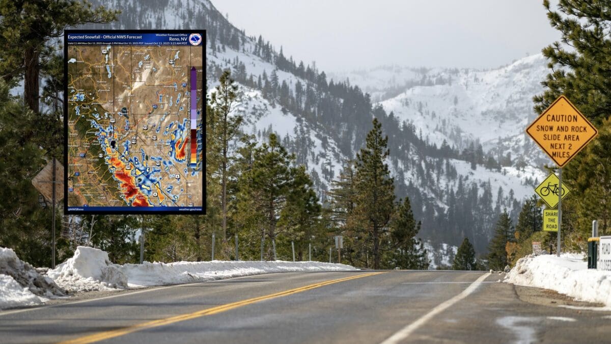
The National Weather Service has issued a Winter Storm Warning and Winter Weather Advisory for multiple regions across the Sierra Nevada, indicating significant early-season snow. Heavy snowfall is anticipated above 6,500 feet, with accumulations ranging from 6 to 36 inches in some areas, particularly along the highest peaks. This storm will create hazardous travel conditions, especially impacting Monday evening and Tuesday morning commutes.
Winter Storm Warning Details
In Western Plumas County and Lassen Park, including the cities of Quincy and Chester, a Winter Storm Warning remains in effect until 5am PDT on Wednesday, October 15th, 2025. Snow is expected above 6,500 feet, with total accumulations of 12 to 18 inches and up to 2 feet at the highest peaks. Travelers should prepare for slippery roads, as hazardous conditions are likely to affect Monday and Tuesday commutes. Snow levels will range from 5,500 to 6,500 feet, dropping to 5,000 to 6,000 feet after Monday night, with the heaviest snowfall anticipated from Monday afternoon through late evening, particularly in the Lassen Park area.
For the West Slope Northern Sierra Nevada, including Blue Canyon, a Winter Storm Warning is also in effect until 5am PDT on Wednesday, October 15th, 2025. Snow is expected above 6,500 feet, with accumulations of 12 to 20 inches and up to 3 feet at higher elevations, especially south of Highway 50. Winds may gust up to 35 mph, contributing to hazardous road conditions that could impact Monday and Tuesday commutes. Snow levels will follow a similar pattern, ranging from 5,500 to 6,500 feet and dropping to 5,000 to 6,000 feet after Monday night, with the heaviest snow expected Monday afternoon to evening.

In Yosemite National Park outside the valley, the Upper San Joaquin River, Kings Canyon NP, Sequoia NP, and surrounding areas including Devils Postpile, Tuolumne Meadows, and Grant Grove, a Winter Storm Warning is in effect from 11am Monday, October 13th, to 5pm PDT Wednesday, October 15th, 2025. Heavy snow is expected with snow levels between 6,000 and 7,000 feet, bringing total accumulations of 1 to 2 feet, with up to 3 feet over the highest peaks. Visibilities may drop below a quarter mile due to falling and blowing snow, making travel very difficult to impossible, particularly during Monday evening and Tuesday morning commutes.
On the Eastern Sierra Slopes, including Aspendell and Whitney Portal, a Winter Storm Warning is in effect from 5pm Monday, October 13th, to 5am PDT Wednesday, October 15th, 2025. Heavy snow is expected, with 8 to 16 inches of accumulation between 7,000 and 9,000 feet and 1 to 2 feet above 9,000 feet. Winds could gust as high as 40 mph, leading to slick and hazardous roads, particularly on Highway 168 west of Bishop. Conditions at Whitney Portal will deteriorate sharply, posing extreme danger to hikers and campers unprepared for winter weather.
In Mono County, encompassing Lee Vining, Coleville, Mammoth Lakes, and Bridgeport, a Winter Storm Warning is in effect from 11am Monday, October 13th, to 11am PDT Wednesday, October 15th, 2025. Heavy snow is expected above 7,000 feet, with 8 to 16 inches of accumulation and up to 3 feet along the Sierra crest. Communities along Highway 395 may see 1 to 4 inches of snow. Ridge winds could gust up to 70 mph, potentially bringing down tree branches and making travel very difficult, especially through mountain passes like Sonora and Tioga. The heaviest snowfall is expected Monday night through Tuesday morning, with snowfall rates of 1 to 2 inches per hour.
Winter Weather Advisory Details
For the Greater Lake Tahoe Area, including South Lake Tahoe, Markleeville, Stateline, Truckee, Glenbrook, Tahoe City, and Incline Village, a Winter Weather Advisory is in effect from 11am Monday, October 13th, to 11am PDT Wednesday, October 15th, 2025. Heavy snow is expected above 7,000 feet, with accumulations of 6 to 12 inches and up to 2 feet along the Sierra crest. At lake level, 1 to 3 inches of snow may accumulate. Ridge winds could gust up to 60 mph, potentially downing tree branches and making travel difficult, especially through mountain passes like Donner, Carson, and Ebbetts. Hazardous conditions are expected to impact Monday evening and Tuesday morning commutes.
Safety and Preparedness Tips
Travelers should monitor road conditions through quickmap.dot.ca.gov or by dialing 511 for the latest updates. If travel is necessary, prepare a winter storm kit with essentials like tire chains, booster cables, a flashlight, shovel, blankets, extra clothing, food, and water. Delaying travel, if possible, is advised due to dangerous conditions expected Monday night through Tuesday morning. Ensure vehicles are winterized with proper tires and a full tank of gas. For those in the backcountry, particularly near Whitney Portal, prepare for extreme winter conditions and consider postponing trips to avoid risks.