
By Unofficial Networks | Location Denver, Colorado | September 26, 2025
Colorado’s Fall Foliage is Peaking Early: Grab Your Weekend Views Before It’s Too Late!
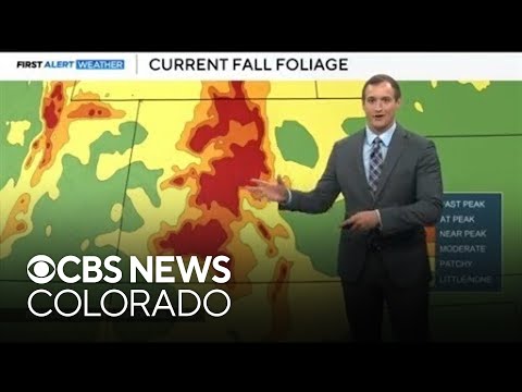
If you’re a Colorado leaf-peeper, you’ll want to pay attention to this weather update from a recent forecast video that’s got everyone buzzing about the early peak. The clip, shared on YouTube (check it out here), features a local meteorologist breaking down the current conditions and what’s coming next. Here are the highlights and why this weekend might be your best shot at catching the show.
The Foliage Scoop: Peak Colors Ahead of Schedule
According to the forecast, we’re already seeing those deep, dark reds and fiery oranges hitting peak or near-peak levels across the high country. And get this—it’s running about 5 to 10 days ahead of the usual schedule! If you’ve been procrastinating on that scenic drive or hike, this weekend is probably the last reliable window to soak it all in before the leaves start dropping en masse. The meteorologist sounds pretty confident: clear skies and intact foliage make for a spectacular display right now.
Pro tip: Head to spots like Rocky Mountain National Park or the San Juan Mountains for prime viewing.
Today’s Weather: Picture-Perfect Fall Vibes
As of today (September 26, 2025), things are looking calm and classic for late September. We’re sitting at a comfortable 75 degrees at the airport—right on par for this time of year. High pressure is calling the shots, keeping everything dry, sunny, and mild. It’s basically “copy and paste” weather through Saturday: shorts and T-shirt territory during the day, with temps creeping up a bit. No rain in sight, so outdoor plans are a go!
Weekend Forecast: Warm and Dry, But Change is Brewing
- Friday: Expect highs around 82 degrees in the metro areas like Denver. Mornings will be crisp in the upper 40s to low 50s—grab a light sweater for the bus stop or early commute—but by afternoon, it’s all sunshine and no extra layers needed.
- Saturday: Similar vibes, with temps dipping slightly to about 79 degrees. Still plenty warm for the eastern plains (70-80 degrees) and the high country (60-70 degrees at peak heating).
This high-pressure “shield” is fending off any moisture for now, keeping things bone-dry. But keep an eye on that cutoff low-pressure system lurking to the southwest—it’s slowly inching our way.
Heads Up: Storms Return Sunday and Monday
By Sunday, the pattern shifts as high pressure slides east, opening the door for statewide storm chances. Pack the rain jacket, umbrella, and maybe an extra layer, because it’ll feel more like true fall. Temps stay at or above average, but the dry streak ends with potential showers lingering into Monday. After that, high pressure rebounds, restoring stability.
Overall, the extended forecast keeps us right where we should be temperature-wise—no wild swings. Eastern plains hover in the 70s-80s, while the mountains stay comfy in the 60s-70s.
Looking Ahead: First Freeze and Snow on the Horizon?
The forecaster throws in a fun (or foreboding, depending on your vibe) reminder: October is approaching, and historically, our first freeze typically occurs around October 7th. Measurable snow? Typically, October 18th. If you’re like the meteorologist (who admits to having a winter countdown going), this is exciting news. Time to start prepping those gardens or dusting off the skis! Personally, I’m all for the sweater weather, but I’ll savor these warm days while they last.