[Post Courtesy of NOAA/NWS]
Key Points
- The past several weeks have been very warm west of the Rockies, due to a persistent western North American ridge
- The ridge will retrograde westward in 7-10 days, with the coldest air of the season likely west of the Rockies
- Aside from Montana (upslope precipitation), this will continue a dry pattern for the western U.S.
- Skillful use of the ensembles is the best way to obtain confidence at 7-10 day lead times
- Deterministic solutions are still valuable because they highlight the potential for individual shortwaves that are not apparent in the ensemble mean
Current Pattern:
The western U.S. has been under the influence of a strongly positive phase of the Pacific/North American (PNA) Pattern for some time. This pattern has been characterized by an impressive 500mb ridge over most of the western U.S. and Canada, and equally impressive troughs situated along both sides. An anomalous ridge over the North Pole is making it difficult to establish circumpolar flow, leading to a highly amplified pattern. Here is the current analysis from this morning, 12 UTC (5 AM MST) 13 Dec:

Start of Pattern Shift:
These large scale patterns are controlled by processes called Rossby Wave Dynamics. Highly amplified flow (like we are currently seeing) is often associated with lower Rossby wave phase speed. In other words, this type of pattern has a tendency to remain nearly stationary, or even retrograde to the west. Over the past week, we’ve seen it remain nearly stationary. Over the next 7-10 days, the global ensemble predictions systems are suggesting we will see a slight, but significant shift westward, bringing colder air from Canada into the West.
One major step in this process occurs early this weekend (graphic below valid for 12 UTC (5 AM MST) 16 Dec), as a shortwave trough slides down the eastern side of the Canadian Rockies (shown below) and then cuts off westward off the U.S. Rockies (not shown), putting a major dent into the 500mb ridge over western North America.
Potential Large Pattern Shift:
The next step occurs as the ridge rebuilds, but is forced to do so further west — from just off the West Coast northward into Alaska. This is where the deterministic models are not in agreement, and one needs to look to ensembles for guidance… Below are the 12 UTC (5 AM MST) 13 Dec runs valid 00 UTC (5 PM MST) 22 Dec of just two of these models (GEFS and GFS). GEFS is on the left, and the deterministic GFS is on the right. Note there are similarities, but also differences in the magnitude and location of the high pressure ridge. Also note these are just two of many different models, this does not include other solutions such as the European.
The Result:
The pattern hinted by these models, with a 500mb ridge over Alaska, allows for a lobe of Arctic air from Canada to move southward along the eastern side of the ridge and come southward west of the Rockies. The individual shortwave troughs associated with these Arctic surges are almost never apparent in the ensemble solutions at these lead times, due to averaging over all of the ensemble members, so we have to look at large-scale clues like the Alaskan ridge to infer them. Furthermore, the most recent run of the ECMWF (not shown) marks a divergence from the past few runs, which showed something more similar to its own ensemble and the GEFS/GFS solutions.
Looking at the 500 mb height model ensemble mean loop from days 2 through days 14 it shows quite nicely the potential pattern change. This loop (image below on left) shows how our current ridge breaks down, then reestablishes itself further west. This could allow cold arctic air to filter in, which is show quite nicely by the GEFS 500 mb temperature means.
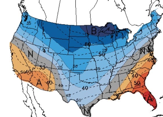
Putting all the pieces together, it is likely that areas west of the Rockies will see their first shot of Arctic air this winter beginning sometime in the December 21-24 time frame. It is unclear what exactly the southward extent of this colder air might be, or how long it will remain in place. Check out the CPC 6 to 10 Day and 8 to 14 Day outlooks to see more how this pattern may affect the weather patterns to end the year.
6-10 Day Temp + Precip Outlooks

8-14 Day Temp + Precip Outlooks

Write up by Jonathan Rutz. Still have questions on what this means for your location? Contact your local NWS Office for specific location details.


