

Report: Powderchasers.com
THE ATMOSPHERIC RIVER RETURNS TO CALIFORNIA LATE THIS WEEK INTO THE WEEKEND! 2-4 FEET OF SNOW ARE LIKELY AT THE SUMMITS OF MOST TAHOE RESORTS THROUGH SATURDAY WITH UP TO 5 FEET POSSIBLE AT THE SUMMIT OF MAMMOTH
For those of you that may have forgotten what the February burial looked like in the Sierra you may get another chance to see deep snow late this week into the weekend. It wont be as deep as some of the AR events we saw this past winter but decent dumps are likely for a wide area of the Sierra Range. Models are showing up to 2-4 feet for many upper locations with 9-15 inches at the bases. This storm has the potential to bring epic amounts of snow to many areas through late Saturday (Not an April Fools Joke).
Strong winds and warmer temperatures will slam into the Sierra Range Friday. Heavy precipitation will be falling Friday morning above 7500 feet. Upper elevations should grab a foot or more during the day. Wind holds and upper mountain terrain closures are likely!
Snow continues into Saturday with a cold front due early. Colder air will usher in heavy snowfall to the bases and high quality POW for mid and upper elevations. Snow will be falling at lake level on Saturday! Strong winds may keep upper mountains on hold at many ski areas prone to wind impacts in the morning. Winds may ease by afternoon Saturday (Its still too far out to get specifics).
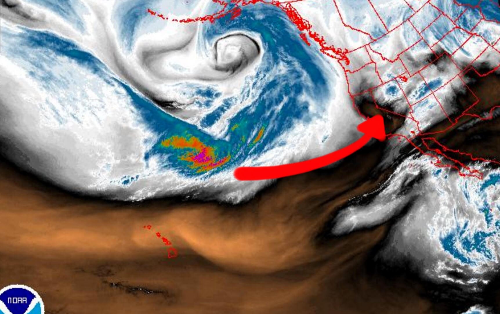
Below: Initial surge of moisture and West/Southwest winds Friday

Snow intensity may decrease somewhat Saturday mid morning or afternoon in the northern Sierra. The Southern Sierra near Mammoth may still see moderate intensities continue.
Sunday could be a transition day with decreasing winds and snow showers. Another system will move into the Sierra Sunday afternoon through Monday with a good chance of moderate snowfall.
Best day to chase powder according to Powderchaser Steve at Powderchasers.com and Opensnow.com
“I like Saturday morning especially for resorts less prone to wind issues. Saturday afternoon might bring a break with a glimmer of hope for mid elevation openings. Sunday should deliver upper mountain openings at many resorts if we are lucky.”
Who is going to win with the highest snow totals?
“The models are still 5 days out so it’s a tough call. Currently my speculation is Mammoth will come out ahead of the others with a slight emphasis on southern resorts. Higher elevations may also sneak out as much as 3-4 feet at the summit! Don’t expect the summit to open until perhaps Sunday at the earliest.”
Confidence?
“Current models decreased total moisture slightly but also brings in colder air. This season has seen some models start out very bullish only to fizzle somewhat as we got 2-3 days out. That can definitely happen! I have moderate confidence for 2-4 feet at the summits but better confidence on 1-3 feet to stay conservative. As an outlying possibility of models hold up on the high end 30-50 inches is possible in some isolated locations above 10,000 feet. Its a gamble forecasting snow totals 5 days out so lets hope the models hold up.”
Caveats?
“Winds have been an issue all season for the Sierra! It’s going to be a game of finding resorts that open decent terrain that fall under the high wind criteria. It’s definitely a big issue especially Friday and perhaps Saturday!” The sleeper storm Sunday night that lands light or moderate snow for Monday morning could be the most dependable chase.
Below: Total moisture for northern California through Sunday AM
