
 Image: accuweather.com
2.jpg)
WINTER OUTLOOK 2014/2015 – LAST POST FOR 2013/14 – ANNUAL FUND DRIVE
From Powderchasers.com
Last post for 2013/14 season– Annual Fund Drive
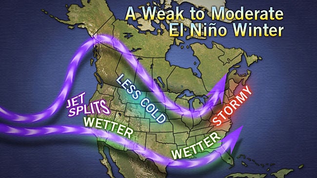
Long range predictions instill decent confidence in the 60-90 days model outlooks. Current trends are for warming waters over the Pacific and weak El Nino developing during the summer months. The early summer trend should be for below average temperatures for the Northern Rockies, and Midwest and above average temperatures for the Southwest. Moisture should be slightly above average for the northern tier States, drier in the Southwest and near normal over the Rockies in the next 60 days.
While it is too early to make any accurate predictions for next season, our best guess is a moderate El Nino winter. If that happens drought stricken California will see some relief, with perhaps less moisture for the Pacific Northwest. The Rockies currently stand in the middle with an equal chance of above or below moisture (Neutral). If EL Nino kicks in strong it will favor the southern mountains. The Wasatch in Utah reaps rewards of both El Nino and La Nina years. East Coast resorts can benefit from EL Nino also!
Was 2013/14 really a bust? Keep reading!
This year Squaw Valley USA Logged a meager 75 inches year to date in late January. February and March trended with higher snowfall (Several double digit days) bringing them up to 259 inches by late March. Average snowfall is around 450 inches. Squaw finished at 297 inches this season versus 326 in the previous year. Most of the snow from last season fell early where this season it fell late. The Wasatch benefited this year at higher elevations with some of the best late April conditions I can remember at Snowbird. The Northwest had significant rain and snow events this season. Fortunately, over 100 inches fell in some areas over a 7 day period in February. Stevens Pass finished the season at 472 inches which is 22 inches above normal! Colorado had a banner season. Breckenridge nabbed 439 inches which is well above normal! Most of central and northern Colorado set record snowfall amounts and edging out Utah in most cases! Consistent storms over the Tetons brought record amounts to both Grand Targhee andJackson Hole. Jackson finished the season at 397 inches at mid mountain and 500 towards the summit! They had a period where it snowed nearly 2-3 weeks without breaks. Stowe closed with 266 inches of natural snowfall just shy of normal.

*This is our last post for the season* Please consider supporting Powderchasers with a donation. Thank you for all that have already donated!
10% of all donations goes to avalanche forecast centers in the West (UT, CO, NW).
Enjoy the summer! Posts will resume in September or October with future weather predictions and hopefully some early powder alerts.
Powderchaser Steve