


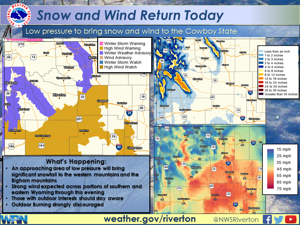
Jackson Hole is under a Winter Weather Advisory tonight into tomorrow. NOAA is forecasting up to 12+ inches of snow for the Tetons with snow levels as low as 7,500-feet.
Today at Jackson Hole.
Weather Message From NOAA:
“A strong cold front will make its way across the Cowboy State today, bringing rain, thunderstorms, wind and snow to the forecast area. Scattered showers and isolated thunderstorms will continue northward this morning over central and western portions. Snow will occur in the mountains, with levels dropping to near 7,000 ft by this evening and continue overnight tonight. The shower activity will become more widespread through the morning hours, as the front enters western portions. Strong winds will develop by early afternoon, from southern Lincoln County to Natrona County. Windy conditions will occur across much of the area today, as well. Snow will develop late this afternoon in the Bighorns and continue through midday Tuesday. Precipitation will linger over northern and western portions tonight.”

WINTER WEATHER ADVISORY for WYOMING:
URGENT - WINTER WEATHER MESSAGE
NATIONAL WEATHER SERVICE RIVERTON WY
258 PM MDT MON OCT 3 2016

...SIGNIFICANT MOUNTAIN SNOW EXPECTED OVER THE WESTERN MOUNTAINS
AND BIGHORN MOUNTAINS THROUGH TUESDAY MORNING...

.A STRONG AUTUMN PACIFIC STORM WILL CONTINUE TO BRING POTENTIALLY
HEAVY SNOW TO THE WESTERN MOUNTAINS WITH STRONG WINDS TONIGHT.
SNOWFALL WILL MOVE EAST OF THE DIVIDE THIS EVENING...WITH
SIGNIFICANT SNOWFALL POSSIBLE OVER THE BIGHORN MOUNTAINS THROUGH
TUESDAY MORNING. IN ADDITION TO SNOWFALL... STRONG WINDS OF 30 MPH
WITH GUSTS TO 45 MPH WILL BE POSSIBLE ON THE PASSES AND EXPOSED
RIDGES.

TETON AND GROS VENTRE MOUNTAINS-SALT RIVER AND WYOMING RANGES-

...WINTER WEATHER ADVISORY REMAINS IN EFFECT UNTIL 6 AM MDT
TUESDAY...

* TIMING...SNOW WILL CONTINUE TODAY WITH SNOW LEVELS DECREASING
  TO 7500 FEET.

* SNOWFALL...6 TO 12 INCHES WITH LOCALLY HIGHER AMOUNTS ABOVE
  9000 FEET.

* WIND AND VISIBILITY...WEST TO SOUTHWEST WINDS OF 30 MPH WITH
  GUSTS TO 45 MPH ON THE MOUNTAIN PASSES AND EXPOSED RIDGES
  CAUSING BLOWING AND DRIFTING SNOW WITH VISIBILITY BELOW A
  QUARTER MILE.

* IMPACTS...HUNTERS AND CAMPERS SHOULD BE PREPARED FOR ADVERSE
  WINTER WEATHER. IT WILL BE IMPORTANT TO KEEP DRY AND HAVE
  ADEQUATE WINTER CLOTHING TO AVOID HYPOTHERMIA. TRAVEL
  DISORIENTATION MAY ALSO DEVELOP DUE TO DETERIORATING
  CONDITIONS.